
Oamaru
| Oamaru | ||
| Geographical location | ||
|
||
| Coordinates | 45 ° 6 ′ S , 170 ° 58 ′ E | |
| Region ISO | NZ-OTA | |
| Country |
|
|
| region | Otago | |
| District | Waitaki District | |
| Ward | Oamaru Ward | |
| Administrative headquarters | Seat of Administration for the Waitaki District | |
| Local foundation | 1853 | |
| Residents | 13 050 (2013) | |
| height | Height of sea level | |
| Post Code | 9400 | |
| Telephone code | +64 (0) 3 | |
| UN / LOCODE | NZ OAM | |
| website | www.waitakinz.com/visit-waitaki/explore-waitaki/oamaru/ | |
| Photography of the place | ||
 View of Oamaru from the south |
||

Oamaru ( ) is a town in the Waitaki District in the Otago regionon the South Island of New Zealand . The city is the administrative seat of the district administration.
Origin of name
The name Oamaru comes from the Māori language and means place of the Maru . The exact identity of the " Maru " is not known, which is why only guesses can be made. The place name is a Shibboleth : the local southern dialect of the Māori ignores the first A in the name (AUH-muh-ROO). Māori with the northern dialect tend to describe this (correct) pronunciation as incorrect. You stretch the A (o-UH-muh-ROO). The pronunciation can be used to determine whether a speaker comes from the north or the south.
geography
The city is 80 km south of Timaru and 120 km north of Dunedin on the Pacific coast . Oamaru is the eastern gateway to the Mackenzie Basin across the Waitaki River valley .
Most of the city's streets are named after English rivers. The main street is Thames Street and other major streets are Severn Street and Tyne Street .
history
The historic city center of Oamarus

Detail of a classical building made from typical regional limestone

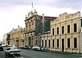
Waitaki District Council Building (former main post office)

Beware of penguins!

Steampunk - work of art in public space

Oamaru Steam and Railway


Significant archaeological finds in the Oamaru area , especially at the mouth of the Waitaki River , where archaic moa hunters left traces around 1100, indicate that the area was already inhabited at that time.
According to James Cook's logbook, on February 20, 1770, he was with the Endeavor three kilometers from the coast, very close to the mouth of the Waitaki . He noted that the land was very flat and that the hilly hinterland only began four to five miles inland. The region seemed very desolate to him and showed no sign of residents. He anchored there for four days.
In fact, there lived in the Māori region and from 1814 onwards there were isolated seal hunters who hunted the New Zealand fur seals . After a Pā at Kaiapoi near Christchurch was sacked in 1831 under the leadership of the Māori tribal leader Te Rauparaha , the refugees moved south and settled near Kakanui and in the area between Pukeuri and Waianakarua , including the area of today's city of Oamaru .
Edward Shortland visitedthe region by landfrom Waikouaiti in 1844. He made a map and alsomapped Oamaru . He was one of several Europeans to explore the region on foot in the 1840s. James Saunders became the district's first European government representative before 1850 when he settledin the area to tradewith the Māori at the Waitaki Estuary.
In the 1850s, more and more European settlers came to the area, including Hogh Robison , who built a hut out of turf on the Oamaru River in 1853 . The site was declared a city in 1859. Oamaru grew to become the center for the agricultural hinterland between the Kakanui Mountains and the Waitaki River . In addition, the port in Cape Wanbrow gained increasing importance as a trading and fishing port.
The development of the frozen meat industry, which arose in nearby Totara , also led to the boom in Oamaru . Institutions such as the Athenaeum , Waitaki Boys High School and Waitaki Girls High School were established. The Ototara Limestone , a local limestone, is ideal for processing and so the artistic use of the limestone by the craftsmen shaped the cityscape. The Forrester & Lemon architectural association built many of the public buildings and structures for companies in today's historic city center. In the time of the 1880s Depression, Oamaru was one of the most beautiful and financially strongest cities in Australasia and about the same size as Los Angeles at the time . After economic development slowed, the population continued to grow until the 1970s. The closure of the port and the stoppage of New Zealand industry hit Oamaru very hard. In response, Oamaru was one of the first New Zealand cities to reflect on its architectural heritage and its commercial and tourist use.
Since 2000, the city has given its name to Oamaru Peak , a peak on Ross Island in Antarctica .
Infrastructure
administration
The city is the administrative seat of the Waitaki District . The historical status of being the second most important center in the Otago region after Dunedin is, however, in jeopardy, as the importance of the city of Queenstown in central Otago is growing steadily due to its position in tourism.
Transport links
The city is on New Zealand State Highway 1 .
Oamaru is connected to the South Island's main railway line, the Main South Line . Freight traffic runs here regularly. Passenger traffic was discontinued in 2002 with the abandonment of the " Southerner " train .
media
The city's only daily newspaper is the Oamaru Mail . Oamaru Heritage Radio broadcasts on FM and on web radio.
Attractions
Historical old city
Many 19th-century public buildings were constructed from the light-colored limestone found in the region, which was quarried particularly near Winston . The historic city center - there are only a few streets - has an almost closed development from the Victorian era and is considered one of the most impressive historical complexes in New Zealand. This part of the city and the port area are under monument protection .
A public gallery, the Forrester Gallery, opened in 1983 in the former neoclassical building of the Bank of New South Wales . Other buildings have also been restored. A trust fund was opened and restoration work on the historic port district was pushed ahead. At the beginning of the 21st century, cultural heritage became an important economic factor. It was supplemented by historical facilities, such as the museum railway of the Oamaru Steam and Railway Society , which uses the tracks of the former port. Artists have settled.
Due to the high historical preservation of the buildings, the city is applying as the steampunk capital, adding elements of movement to the Victorian ambience and attracting fans every year.
Penguin colony
The Oamaru Blue Penguin Colony , a colony of little penguins, lives in the area of the harbor . There is a colony of yellow-eyed penguins just south of town . To this day, penguins live occasionally under some of the sheds near the beach. After dark they can be seen on the way to their nests.
Personalities
- Heath Blackgrove (born 1980), cyclist
- Richie McCaw (born 1980), rugby player
See also
Web links
- Homepage . Waitaki District Council,accessed December 28, 2015.
- Homepage . Tourism Waitaki,accessed September 2, 2014.
Individual evidence
- ↑ Waitaki population rises slightly . Oamaru Mail , August 9, 2014, accessed July 24, 2016 .
- ^ Charles Rawlings-Way et al. a .: New Zealand . Lonely Planet 2010, p. 597.
- ^ Homepage of the Oamaru Steam and Railway Society
- ^ Eleanor Ainge Roy : How an ordinary New Zealand town became steampunk capital of the world . In: The Guardian . August 30, 2016, accessed September 14, 2016 .
- ↑ Oamaru - The City of Steampunk . KiwiQuest Ltd , accessed May 5, 2019 .