Timaru
| Timaru | ||
| Geographical location | ||
|
|
||
| Coordinates | 44 ° 24 ′ S , 171 ° 15 ′ E | |
| Region ISO | NZ-CAN | |
| Country |
|
|
| region | Canterbury | |
| District | Timaru District | |
| Ward | Timaru Ward | |
| Administrative headquarters | Seat of the administration for the Timaru District | |
| Residents | 25th 887 (2013) | |
| height | 6 m | |
| Post Code | 7910 | |
| Telephone code | +64 (0) 3 | |
| UN / LOCODE | NZ TIU | |
| Photography of the place | ||
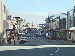
 The Stafford Street in the center of Timaru |
||
Timaru is a port city in the Timaru District of Canterbury on the South Island of New Zealand . The city is the seat of the Timaru District Council .
Origin of name
The origin of the name Timaru is not clear. According to one assumption, the name is said to have been derived from a transformation of the term "Te Maru" . In the Māori language this means something like "the protected place" . Another assumption derives the name from “ti” for Cabbage Tree , a 15 m high species of club lily found only in New Zealand , and “maru” for shady.
geography
The city is located around 147 km southwest of Christchurch and around 174 km north-northeast of Dunedin on the east coast of the South Island. To the northwest of the port of the city extends the Caroline Bay and a little further north the Washdyke Lagoon , whereas south of the port to Patiti Point the coast is interspersed with rock formations. The urban area is crossed by numerous small streams (brooks), slightly larger rivers flow into the Pacific Ocean around 12 km south with the Pareora River and around 15 km northeast with the Opihi River .
geology
Timaru was built on a lava scree field of the Mount Horrible volcano , which was active around 2 million years ago and is now considered extinct. Similar to the volcanoes of the Auckland Volcanic Field , the volcano is said to have had only one major eruption phase or several eruptions in a very short time. Investigations have shown that the volcano spread its ash over 130 km² and was able to create layers of ash over 5 m thick. This explains the fact that the urban area is not level, although the entire hinterland of the Canterbury Plains is relatively flat to the north. The rock from the volcano was used to build the local "bluestone" houses. Blaustein ( bluestone ) is a blue-appearing in wet form form of dolerite -Gestein.
history
Early Māori settlement
Māori seem to have used the area around Timaru many years before the arrival of the first Europeans in the 19th century as a resting place during canoe trips along the east coast. In the area, traces of Māori stone art have been found in more than 500 places , especially under rock overhangs and the caves of the Opuha and Opihi river valleys, west of today's Timaru . Archaeologists assume that Māori tribes ( Iwi ) had settled in the area permanently before 1400. During the 17th century, the Ngāti Mamoe who settled here were pushed south into the area of today's Fiordland National Park by the invasion of the Ngāi Tahu from the northern area of the southern peninsula .
Settlers from Europe in the 19th century
The settlement by Europeans began with the establishment of a whaling station in 1838/1839 by the Weller brothers at Patiti Point , near today's city center. The supply ship The Caroline provided the name for the bay on the city's coast. The Levels sheep farm was later built on land acquired from the Rhodes brothers . In 1859, when only a few settlers lived in Timaru , the Strathallan from England reached the city with 120 immigrants on board. Constant quarrels between the brothers and the city administration over land initially led to the establishment of the two communities Government Town and Rhodestown in the port area, which were finally merged in 1868.
Due to the loss of several ships on the coast, the planning of an artificial port was started in 1877. This triggered the shift of sand along the Pacific coastline to the south, which accumulates opposite the northern breakwater. That was the beginning of a large-scale land reclamation around the Caroline Bay District , an area that subsequently saw population growth.
20th century
The growth of the city had stopped unabated during the 20th century, the majority were wooden houses in colonial style ( bungalows built) in various development areas. The cast iron lighthouse at Jack's Point was commissioned in 1903.
population
In the 2013 census, the town had 25,887 inhabitants, 0.57% more than in the 2006 census, although the individual districts have developed somewhat differently.
economy
Timaru is the administrative, commercial and industrial center of the Timaru District and the southern part of the Canterbury region . Fruit, vegetables and cereals are grown in the hinterland and some are processed in the city. Wool and meat from sheep and cattle breeding can be found in the city's markets and are largely shipped together with other goods via the city's port, which also serves as a base for the Timaru fishing fleet .
Infrastructure
Road traffic
The New Zealand State Highway 1 runs through Timaru and connects the city with all major cities and centers on the east coast of the South Island. A regular bus and minibus transportation to Christchurch , Dunedin , Invercargill , Queenstown and the Mackenzie District starts from the Visitor Information Center of the city.
Rail transport
Timaru is on the Main South Line , which runs along the coast through the city. In 2002, long-distance passenger transport was discontinued on the section originally used by the Southerner . Since then, the route has only been used by freight trains.
Shipping
The city is visited irregularly by cruise ships.
Air traffic
Timaru has a small airport, Richard Pearse Airport , through which Air New Zealand regularly handles short-haul domestic flights to and from Wellington . The airport is located around 13 km north of Timaru city center and has a 1,280 m long concrete runway from which medium-sized machines can take off and land.
Education
In addition to numerous kindergartens and elementary schools, Timaru has five secondary schools, such as Timaru Girls 'High School , Timaru Boys' High School , Mountainview High School , Roncalli College and Craighead Diocesan School . Further training takes place at the Aoraki Polytechnic .
media
The Timaru Herald , whose printing plant is in Ashburton , has been the local daily for the city and the district since the mid-19th century . The newspaper is also read in the Otago region and the South Canterbury region . The weekly community newspaper, The Timaru Courier, has a circulation of over 24,000 copies and is distributed free to all households on Thursdays. In the city, the two local VHF radio stations, Port FM and Classic, broadcast hits , and there are other VHF stations that belong to larger broadcasting networks.
Attractions
- The South Canterbury Museum is the region's premier museum. It shows exhibits related to geography and the environment, fossil finds, Māori stone art , evidence of the early settlement of the district and local seafaring history, ivory carvings, the natural history collection of EP Seally and information about Richard Pearse , the inventor and his attempts at manned flight in the early years of the 20th century.
- The Aigantighe (a Scottish Gaelic word , pronounced like “egg and tie” in English) Art Gallery on Wai-iti Road is the third largest art museum in the South Island and one of the best art galleries in the country. It shows a collection of New Zealand, Pacific, Asian and European works of art from the 16th century to the present, as well as a collection of sculptures. The gallery was founded in 1956 and is located in a residential building from 1908.
- There are a number of public gardens and parks in Timaru . The Trevor Griffiths Rose Garden at Caroline Bay Park is a new attraction that was created when the Timaru Plaza was remodeled .
- The DB Mainland Brewery on Sheffield Street can be visited and its products can be tasted.
- In the south of the city you will find the large-scale botanical garden, which was laid out in 1864 with a collection of roses and ferns.
- To the west is the well-tended Centennial Park Reserve , which was created in 1940 with a 3.5 km hiking trail through the forested valley of Otipua Creek .
Events
- The annual Summer Carnival takes place in the parkland of the Bay Area during the Christmas holidays through to New Year's Day.
- The Royal Theater on Stafford Street hosts most of the entertainment.
- The No Indications winners of the Timaru Rock Festival 2006 come from South Canterbury , after all they were able to occupy a Top12 place.
Sports
There are several municipal sports facilities in Timaru that meet international requirements. There are sports facilities for rugby , tennis, sailing, swimming, netball , cricket , golf, hockey , croquet and bowling. There is also the South Canterbury Speed Skating Club , which is one of the largest inline speed skating clubs in New Zealand and has an asphalt track suitable for competitions. There are also two swimming pools in the city and rugby games can be held in the Alpine Energy Stadium . Timaru has several golf courses. These include the Highfield, Gleniti , Timaru and those around Pleasant Point , St. Andrews and Maungati .
Personalities
Sons and daughters of the town:
- Sir Robert Reynolds Macintosh (1897–1989), anesthetist (Macintosh spatula)
- Allen Curnow (1911–2001), writer and journalist
- Charles Elworthy, Baron Elworthy , KG, GCB, CBE, DSO, LVO, DFC, AFC (1911–1993), highly decorated officer in the Royal Air Force
- Reginald John Delargey (1914–1979), Archbishop of Wellington
- Ronald Rutherford "Ron" Elvidge (1923–2019), national rugby union player
- Lawrence Leys "Laurie" D'Arcy (* 1947), Australian sprinter
- Penny Hunt , b. Penelope Christine Haworth (* 1948), sprinter
- Richard John "Dick" Tayler (* 1948), long-distance runner
- John Hattie (born 1950), educator
- Les O'Connell (* 1958), rower who became Olympic champion in 1984 in the four-man category
- Danyon Loader (* 1975), swimmer, gold medalist over 200 and 400 meters freestyle at the 1996 Olympic Games, silver medalist over 200 meters butterfly at the 1992 Olympic Games
- Simon Glass (* 1982), ice hockey player
- Marc Ryan (* 1982), track and road cyclist
- Shane Archbold (* 1989), cyclist
- Tomas Walsh (* 1992), shot putter
- Emily Fanning (* 1995), tennis player
Other personalities related to the city:
- Robert James "Bob" Fitzsimmons (1863–1917), boxer, lived and worked as a blacksmith in Timaru. There's a life-size statue of him in the city center.
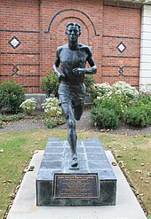
- John Edward "Jack" Lovelock (1910–1949), gold medalist in the 1500 meter run at the 1936 Olympic Games in Berlin, attended the Timaru Boys' High School and gave the school the oak wreath, which has been preserved to this day, for the award ceremony. There has been a statue of him on the school grounds since 2002, created by the same sculptor who created Bob Fitzsimmons' at Strathallan Corner. There is also the Lovelock Oak, the Olympic oak he received along with the medal .
- Michael John "Mike" Minogue QSO (1923–2008), politician; attended Timaru Boys' High School
- Richard Pearse (1877–1953), aviation pioneer; lived in Waitohi, 15 kilometers north of Timaru
- Kevin Smith (1963–2002), actor known from the television series Xena - The Warrior Princess, grew up in Timaru
Trivia
- At the Olympic Games in Berlin in 1936 , John Edward “Jack” Lovelock won the 1,500-meter run, and at that time all gold medal winners were also awarded a so-called Olympic oak . Since he was not returning to New Zealand himself but moving to Great Britain, friends took the sapling with them, which was planted in front of Timaru Boys' High School in 1941 . The " Lovelock Oak" is still there today and has been declared a national cultural asset. Every year, students collect the acorns in order to grow new seedlings.
- The racehorse Phar Lap comes from the area north of Washdyke .
- During 1978 the passenger ship SS Australis (also known as SS American Star or SS America ) was anchored in the port of Timaru for several months before being sold to another shipping company .
- The Timaru crater on Mars is named after the city.
See also
literature
- Helga Neubauer: Timaru . In: The New Zealand Book . 1st edition. NZ Visitor Publications , Nelson 2003, ISBN 1-877339-00-8 , pp. 728-731 .
Web links
- Homepage . Timaru District Council,accessed October 19, 2017.
- Homepage . Caroline Bay Association,accessed on October 19, 2017(English, information on theCaroline Bay Carnival).
Individual evidence
- ↑ a b Timaru with its districts: Washdyke, Glenti, Macrchwiel , Waimataitai , Glenwood, Highfiled, Maori Park, Fraser Park, Seaview, Inlet-Port, Watlington, Parkside , Timaru Gardens, Redruth . Statistics New Zealand , accessed on October 19, 2017 (English, StatsMap: Meshblock analysis from the interactive map).
- ^ Neubauer: Timaru . In: The New Zealand Book . 2003, p. 729 .
- ↑ Topo250 maps . Land Information New Zealand , accessed October 19, 2017 .
- ↑ Megan Miller : It was Horrible, but now it's dead . In: The Timaru Herald . Fairfax Media , August 8, 2012, accessed October 19, 2017 .
- ^ Neubauer: Timaru . In: The New Zealand Book . 2003, p. 728 .
- ^ Richard Pearse Airport . Timaru District Council , accessed October 19, 2017 .
- ↑ Homepage . In: Timaru Herald . Fairfax Media , accessed October 19, 2017 .
- ↑ Homepage . South Canterbury Museum , accessed October 19, 2017 .
- ↑ Jerry Crowe : To protect and preserve a tree rooted in Games . Los Angeles Times , August 20, 2007, accessed October 19, 2017 .
- ↑ Kevin Berry : Seedlings for Sydney . (PDF 374 kB) Journal of Olympic History , January 2000, accessed on March 4, 2014 (English).


