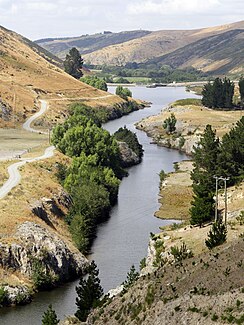
Opuha River
| Opuha River | ||
|
View of the river dammed up by a weir |
||
| Data | ||
| location | Canterbury , South Island , New Zealand | |
| River system | Opihi River | |
| Drain over | Opihi River → Pacific Ocean | |
| origin |
Lake Opuha 44 ° 0 ′ 4 " S , 170 ° 53 ′ 31" E |
|
| Source height | 350 m | |
| muzzle |
Opihi River Coordinates: 44 ° 10 ′ 30 " S , 170 ° 59 ′ 34" E 44 ° 10 ′ 30 " S , 170 ° 59 ′ 34" E |
|
| Mouth height | 130 m | |
| Height difference | 220 m | |
| Bottom slope | 8.8 ‰ | |
| length | 25 km | |
| Catchment area | 64.192 km² | |
The Opuha River is a 25 km long river in the Canterbury region of the South Island of New Zealand .
geography
The Opuha River is formed today with the outflow of the Lake Opuha reservoir and is located around 12 km north-northeast of the town of Fairlie . The reservoir is mainly fed by the two rivers North Opuha River and South Opuha River , which formed the Opuha River before the reservoir was created by their confluence . After about 25 km in a south-easterly direction, the river finally flows into the Opihi River as a left tributary .
The New Zealand State Highway 79 runs part of the southwest at a distance of 1 to 2 km parallel to the Opuha River until it crosses the river at Skipton Reserve and then turns east.
literature
- Edward Hearnshaw, Ross Cullen, Ken Hughey : Ecosystem services review of water projects . In: Australian Agricultural and Resource Economics Society Annual Conferenc . 2010 (English, online [PDF; 877 kB ; accessed on January 25, 2020]).
Individual evidence
- ↑ a b Opuha River . In: NZ Topo Map . Gavin Harriss , accessed January 25, 2020 .
- ↑ Coordinates and longitudes were determined using Goggle Earth Pro Version 7.3.2.5776 on January 25, 2020
- ^ Hearnshaw, Cullen, Hughey : Ecosystem services review of water projects . 2010, p. 6 .
- ↑ a b c Topo maps . Land Information New Zealand , accessed January 25, 2020 .
