Fiordland National Park
| Fiordland National Park | ||
|---|---|---|
| Milford Sound | ||
|
|
||
| Location: | Southland , New Zealand | |
| Next city: | Te Anau | |
| Surface: | 12,570 km² | |
| Founding: | 1952 | |
| Visitors: | approx. 500,000 (2005) | |
| Address: | Fiordland National Park Visitor Center Department of Conservation Lakefront Drive PO Box 29, Te Anau New Zealand |
|
The Fiordland National Park is the largest national park in New Zealand with an area of over 12,500 km² . It covers most of Fiordland , the mountainous south-western tip of the South Island , which is characterized on the west coast by fjords such as Milford Sound and Doubtful Sound , in the east by widely ramified lakes.
Together with the Westland , Mount Cook , Mount Aspiring National Park and smaller protected areas, the Fiordland National Park forms the so-called Te Wahipounamu World Heritage Area . It was established in 1952 and is still the most inaccessible part of New Zealand to this day. Since 1990, the area is part of the World Heritage of UNESCO . The fjords in particular are important destinations for New Zealand tourism.
The up to 2,746 meter high mountains of the park are covered by temperate rainforest up to the tree line , as the western side of the mountain range is one of the rainiest areas on earth. The flora, which consists mainly of pseudo-beeches , is mostly on a thin layer of soil, which is why tree and debris avalanches are frequent.
Many New Zealand bird species live in Fiordland. It serves as a retreat for the South Island Takahe, the last of the kakapos lived in the park until they were brought to an island off the coast for protection. Thick- billed penguins and New Zealand fur seals live in the fjords .
The lakes in the park are both the deepest in New Zealand and the largest in area in the South Island. A cavern power station is located on Lake Manapouri , the establishment of which led to New Zealand's first large organized environmental movement.
geography
geology
Fiordland National Park begins in the north at Martins Bay and extends to the Waitutu Forest in the south. In the west it is bounded by the Tasman Sea and in the east its border runs along a chain of large, glacial lakes. The park includes several islands, the larger of which are Breaksea Island , Outer Gilbert Island , and Entry Island . The better known Secretary Island and Resolution Island are also off the coast, but are not part of the national park.
Like all of New Zealand, Fiordland Park is located on the Pacific Ring of Fire , one of the most active tectonic areas on earth. The formation of today's Fiordland began 500 million years ago when pressure and heat formed shale and granite below the surface of the earth . The pressure between the Australian and Pacific plates pushed them above the surface of the earth. Due to the changing climate, which triggered changing water levels, they were sometimes above the water surface, sometimes below, where limestone deposits formed limestone mountains . The mountains are still pushed upwards by plate tectonics, while the rain that is prevalent in the area simultaneously causes unusually heavy erosion.
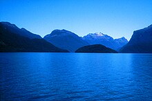
During the ice ages, massive glaciers formed, which cut deep into the mountains and abraded them. This created the 14 fjords that were later filled with seawater and extend up to 40 kilometers into the interior. These include Milford Sound , Doubtful Sound and Dusky Sound . The mountains directly surrounding them reach heights of up to 2000 meters.
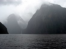
Milford Sound is the only fjord that can be reached via a good road connection. Miter Peak , a mountain with a height of 1692 meters, which lies directly at the deepest point of the fjord at 265 meters, is particularly well-known . The Doubtful Sound is also easily accessible, with 40 kilometers the longest and with 421 meters the deepest fjord. The Browne Falls waterfalls are also located here, with a drop of around 600 meters.
Mountain ranges that lie in Fiordland are the Darren Mountains , the Kepler Mountains, and the Murchison Mountains . The highest elevations in the park reach up to 2746 meters of the Tutoko . The mountains were also formed by glaciers. Often individual massive mountains stand almost 2000 meters above the adjacent valleys. In the southern Waitutu area there is a terraced landscape in which rock forms from 600,000 years ago are visible on a total of ten terraces.
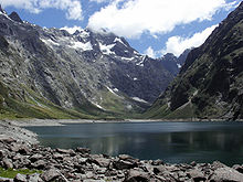
Inland there are numerous glacial lakes, including Lake Te Anau , Lake Manapouri , Lake Monowai , Lake Hauroko, and Lake Poteriteri . Lake Hauroko is the deepest with a depth of 462 meters and Lake Manapouri, enclosed by the Cathedral Mountains , is the second deepest lake in New Zealand with a depth of 444 meters. Lake Te Anau has the second largest surface area of the New Zealand lakes with 344 km². Large lakes like Lake Te Anau or Lake Manapouri are about 200 meters above sea level, so their bottom is about 200 meters below sea level.
The origins of Fiordland also ensured that numerous waterfalls were created, including Sutherland Falls and Browne Falls , both of which fall over 500 meters. During the rainfalls, waterfalls often spontaneously form on the many cliffs, which can reach heights of several hundred meters, but disappear again after the rain.
climate
Fiordland has a strongly oceanic, temperate climate. The average temperatures at sea level range from five degrees in June / July to 23 degrees in January. It rains more than 200 days a year. The rain is evenly distributed over the year. Strong foehn winds are common to the west of the mountains . The weather is strongly influenced by the westerly winds of the Roaring Forties . The winds of the west wind drift , which absorb water over the Tasman Sea and let it rain down over the mountain ranges of the New Zealand Alps ( incline rain ), result in the heaviest rainfall on earth on the west side of the mountains. Approximately 8000 mm of rain falls in Milford Sound each year. In Te Anau the amount of rain is still 1200 mm. For comparison: In Berlin there is an average of 600 mm, in London almost 800 mm precipitation per year.
Flora and fauna
Flora and fauna in Fiordland depend on the altitude and the amount of rain. The latter is larger to the west of the peaks than to the east of them. The entire land fauna and flora is shaped by the high mountains. There is a rich marine life in the fjords themselves.
Various neozoa are present in the park but are being fought persistently. Wapitis in particular are almost driven away by professional hunters with helicopters, but small mammals such as rats or kusus make it more difficult for hunters. Some islands off the coast are completely neozoa-free, which conservationists use to relocate endangered, native species there.
flora
Due to the immense rainfall, Fiordland has a rich evergreen flora, of which about 700 species worldwide occur exclusively in Fiordland; 24 of them are (alpine) plants adapted to the mountains. Often, however, this only stands on a thin, fertile layer of earth above the mountain slopes, so that tree and debris avalanches often fall. Because of these avalanches, the tree line is already 1000 meters above sea level.
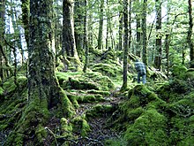
A temperate rainforest grows west of the mountain ranges with a rich undergrowth of mosses, ferns, lichens and shrubs. The most striking form of vegetation in it are pseudo-beeches, of which specimens can be found in the park with an age of up to 800 years. The silver beech is very common, especially at lower altitudes . The red beech is often found in the valleys, dominant in the Eglington Valley , while the black mountain-southern beech occurs at higher altitudes.
In the Waitutu Forest in the south of the park, pseudo-beech trees also grow, which are often surrounded by the stone vines Miro ( Prumnopitys ferruginea ), Rimu ( Dacrydium cupressinum ) and Totara ( Podocarpus totara ). There are a total of 14 different types of stone beef in the park.
Above the tree line up to dominate the snow line Snow grasses along with montane species of Daisy , the Buttercup , especially Ranunculus lyallii , the world's largest Crowfoot Art, and other herbs.
The park includes several swamps and bogs with appropriate vegetation. Scree fields created by glaciers are often overgrown with mosses of the Grimmiaceae family.
fauna

Native land fauna
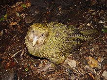
Like all of New Zealand, Fiordland has no native land mammals; Birds often take their place in the ecosystem. Endemic is the South Island Takahe, which was considered extinct from 1898 until it was rediscovered in Fiordland in 1948. The Takahes live in the Murchinson Mountains . After the population dropped from 250 to 500 specimens in the 1950s to around 120 in 1981, it now seems to level off at a population of 160 to 170 Takahes. The only flightless parrot in the world, the kakapo , had its last refuge in Fiordland, but has since been relocated to islands off the coast to protect it from introduced cats, rats, etc. It is probably extinct in the park area itself. The only alpine parrot , the kea, lives in Fiordland as in all of the New Zealand Alps . The Mohua , which is also threatened with extinction, lives mainly in the Fiordland.

The area has the largest collection of forest birds in New Zealand, including the haastkiwi and the striped kiwi , the rock slip and the green slip from the Maori family . In the dense forests of live yellow-crowned parakeet . Birds that only occur in New Zealand and also live in Fiordland include the northern-tailed duck , the crooked beak and the wekaralle , as well as the southern lobster and yellow-headed flycatcher . Auckland beaked and frilled billed ducks benefit from the region's abundant lakes and rivers.
Fiordland is home to around 3,000 species of insects, an estimated 10 percent of which are only found in the park. Often these remain hidden, only predatory flies catch the eye quickly and immediately. The Te-Ana-au-caves are particularly known for their large population of so-called glowworms ( Arachnocampa luminosa , not to be confused with the German glowworms ). The park is home to around 700 species of moth, 35 of which are endemic. About 25 species of the genus Powelliphanta are known in the park. The only known reptile is the Fiordland skink ( Oligosoma acrinasum ).
Neozoa
At the beginning of the 20th century, settlers released European red deer and elk , primarily in order to be able to hunt them. The animals spread and had grown into larger populations by the 1930s. Until the 1960s they had significantly changed the fauna of the Fiordland grasslands, so that they became a threat to the habitat of flightless birds. Since the early 1970s, however, they have been hunted intensively by professional hunters from helicopters, who sold a large part of the meat that was hunted to Germany. The population of the animals decreased by about 80 percent. Since the mid-1980s, the animals can be kept at a low population level. Since the missing animals led to a decline in commercial hunting, the populations have increased somewhat in recent years. The Department of Conservation encourages recreational hunters. Rats, fox cusus and ermines still live in the park and are hunted with traps. About 30 percent of the park is still kusu-free, making these parts of the national park the only regions in New Zealand that do not contain kusus. However, environmentalists fear that over time they will spread across the entire park. The same impassable landscape that protected pristine nature from humans also protects predators from conservationists.
Native eels as well as later introduced trout , rainbow trout and Atlantic salmon live in the lakes and rivers .
In the fjords
Seals and penguins live in the fjords . The thick-billed penguin is endemic to New Zealand's south coast, where around 1,000 to 2,000 breeding pairs live. The largest mating grounds for New Zealand fur seals are off Fiordland. After they were almost wiped out by professional hunting in the 19th century, their number in southwest New Zealand is around 50,000 today. A colony of bottlenose dolphins lives in Doubtful Sound .
Due to the excessive rainfall, the warmer rainwater forms a freshwater layer up to 40 meters high on the surface of the fjords due to its lower density . Since fresh water and salt water have different refractive indices , a large part of the incident light is reflected at their interface, so that in the fjords up to 450 meters deep, deep-sea fish that sometimes love darkness live and other fish species are much closer to the water surface than in other parts of the world. Since the precipitation water is significantly warmer than the lake water, fish species and other living beings can be found here that cannot live elsewhere in this geographical latitude.
Only subtropical sponges , mussels and corals are mentioned , including the world's largest colony of black corals . Common in the fjords are the armpods (Brachiopoda), an animal tribe that has existed for 570 million years and that had its greatest biodiversity in the Devonian .
Park and people
Almost the entire area of the park is state property of New Zealand; the national park is administered by the New Zealand Department of Conservation . The representative of the Māori belonging to the Ngāi Tahu , the Ngai Tahu Maori Trust Board , claims the land before the Waitangi Tribunal .
Fiordland is located in the most sparsely populated region of New Zealand. One of the largest cities is Te Anau with about 2000 inhabitants. With around 4,000 beds, it is the center of tourism and has restaurants and shops equipped for tourists. In addition to tourism, individual farms, small mines and individual fishing boats in Milford and Doubtful Sound are among the noteworthy economic activities. For the most part, however, the area is barely developed wilderness.
The 1,240 sq km Glaisnock in the northern part of the park is a wilderness area designated and may not be entered. Large parts of the southwest park are officially open to people, but so difficult to access that they are in fact wilderness areas. Until the 1970s, individual valleys were still considered completely unexplored.
history
Fiordland once belonged to the territory of the Ngai Tahu, an Iwi of the Māori, like most of the South Island . They used Fiordland for hunting, fishing and collecting jade. According to the current state of research, it is uncertain whether they also established settlements here. When the Europeans discovered the area, there were no Māori settlements in the Fiordland.
The first European to see the country in December 1642 was the Dutch explorer Abel Tasman . The first to thoroughly explore the area were the expedition members, who spent a month in Dusky Sound under James Cook . More researchers followed; the Spaniard Alessandro Malaspina was the first to make drawings that brought the landscape and nature of Fiordland closer to the public.
Malaspina's drawings attracted whalers and seal hunters, who built the first settlements. The commercial seal hunt began in 1792 and by 1820 the number of seals had dropped to a level that made further hunting no longer economically viable. The Fiordland landscape offered the last seals sufficient protection to make hunting too expensive and risky. The seal hunters themselves moved on to the sub-Antarctic islands, where they could hunt larger populations more easily. Whalers who only used Fiordland as a base for further trips stayed longer.
It was not until the middle of the 19th century that exploration of the inland was continued. At the beginning of the 1860s, a small boom broke out in the area after gold discoveries. The resulting settlements in Fiordland did not last long. Further attempts to earn money in or with the Fiordland and to settle there permanently failed because of the hostile nature. In 1875 the British government placed the last of the seal populations under protection. In 1904 an additional 9,000 km² of the area were placed under protection. In 1910 ten moose were released in the park, but they died out again. Since 1990 the park has been part of the UNESCO World Heritage as Te Wahipounamu, along with three others . In 1992 the New Zealand government struck him large parts of the Waitutu area. Since 2004, two smaller areas off the coast have also been protected as Marine Conservatories.
traffic
The only road access into the national park is via State Highway 94 , which runs past Te Anau from Invercargill and crosses the park boundary directly behind it. The 120-kilometer road, Milford Sound Road, from Te Anau leads into the park at the source of the Eglinton River , to end at Milford Sound. The road is famous for its spectacular alpine views and offers numerous opportunities to rest or hike. The street was built between 1930 and 1952 as part of a government project aimed at bringing unemployed people to work. It was marked by numerous accidents in the dangerous wilderness.
Part of the road is the 1270-meter-long Homer Tunnel , which overcomes an incline of 11 percent at an altitude of 945 meters and was the world's longest tunnel with a gravel surface until its last expansion. During the season, around 800 vehicles are on the road a day, 100 of which are tourist buses.
Milford Sound Road is very vulnerable to avalanches in winter. It was closed in the winter months until the 1970s, but then lobbying the tourism industry was able to push through a year-round opening. The last fatality was a road worker who was buried in an avalanche in 1983. A traffic light in front of the Homer Tunnel is intended to regulate traffic from both directions, is only in operation in the high season. The risk of falling victim to an avalanche while waiting in front of the tunnel is considered to be greater than that of getting into oncoming traffic in the narrow tunnel with the traffic lights off. Another important road branches off from Milford Road after Te Anau and leads to Doubtful Sound via Manapouri .
Another road connects Doubtful Sound with Lake Manapouri. There are regular water taxis on the big lakes. There are also larger numbers of private sailing and motor boats. The fjords are often easier to reach via the Tasman Sea than by land. Numerous yachts and around 40 cruise ships sail into the fjords every year, but only a small number of them dock. The park has five landing areas for small land-based aircraft, the most important of which is Milford Sound, with around 8,500 aircraft movements per year. Seaplanes can land on the numerous lakes and fjords.
tourism
About half a million people visit Fiordland Park every year. The main season runs from October to April, but most visitors come in January and February. The main area for tourism is the northwest of the park between Te Anau and Milford Sound. The largest group of visitors are day trippers from Queenstown ; the proportion of foreign tourists is high and has been increasing in recent years.
A smaller road leads south of Te Anau to Manapouri . You can hike inside the park or use commercial helicopter and boat services. Canoeing and kayaking is common in the more developed areas. Fishing is possible all year round on Lake Te Anau and Lake Manapouri, and at least in summer on some rivers. The wild trout stocks in particular play an important role. Various diving providers have established themselves in the fjords and at Milford Sound there is also an underwater observation station with dry access and a civilian submarine with viewing options.
The park has a total of 648 kilometers of hiking trails. There are numerous short distances, for example, from the road to Te Anau to Milford Sound. However, some tracks are also intended for tours over several days. Especially the Great Walks , the Milford Track from Lake Te Anau to Milford Sound, the Routeburn Track and the Kepler Track are internationally known. The Hollyford Track along the Hollyford River is not one of the great walks, but it is also a major tourist destination. At least longer hikes over several days are demanding. During the season the trails are well developed, but require registration, outside the season they are freely accessible, but bridges, footbridges etc. are often dismantled to protect them from winter. The terrain is extremely steep, hardly developed and the immense rain often makes paths impassable for days. Mountaineering is possible in the Darran Mountains. However, there is a risk here that the rain will turn the steep walls, which are often several hundred meters high, into waterfalls. The challenging trails in particular attract an international audience; surveys by the Department of Conservation have shown that around two thirds of the hikers on the Great Walks come from abroad.
The landscape of the park can be seen in the Lord of the Rings films. The scene at the end of the first film , in which the retinue split up, was filmed by the team near Milford Sound; while Frodo, Sam and Gollum roam the swamps in the second part , the landscape around Te Anau can be seen.
Industry
One of the biggest nature conservation debates took place in Fiordland in the 1960s when Consolidated Zinc (later Comalco ) wanted to build a hydroelectric power station and raise the water level in Lake Manapouri by 24 meters, thus merging Lake Manapouri and Lake Te Anau. The countermovement spread across New Zealand, and a list of signatures from the Royal Forest and Bird Protection Society against the project was ultimately signed by 264,907 New Zealanders, roughly one in ten residents of the country. The Labor Party won the 1970 election, among other things, because it spoke out against the project during the election campaign. The underground power station Manapouri Power Station was built; the water level of the lake was not raised. The Meridian Energy Unlimited power plant, which is built 200 meters deep into the mountain, is New Zealand's most powerful hydropower plant . It directs water from Lake Manapouri underground into the Doubtful Sound at sea level and uses the resulting energy. Most of this is needed to operate an aluminum plant at Bluff about 160 kilometers southeast of the lake.
literature
- Charles Begg and Neil Begg: Dusky Bay . Barnes and Noble, Inc. 1966.
- James Cook: Captain Cook in New Zealand: The Journals of James Cook . AH and AW Reed, 1969, 2nd edition.
- John Hall-Jones: Fiordland Explored: An Illustrated History. AH and AW Reed, 1976.
- Barrie Heather and Hugh Robertson: Field Guide to the Birds of New Zealand . Oxford University Press, 1997.
- AW Reed: Myths and Legends of Maoriland . AH and AW Reed, 1967, 3rd edition.
- Kennedy Warne (Ed.): New Zealand Geographic , published bimonthly since 1989.
Web links
- Information from the New Zealand government ( Memento of October 11, 2011 in the Internet Archive )
- UNESCO information ( Memento of May 11, 2008 in the Internet Archive ) (English)
- Entry on the UNESCO World Heritage Center website ( English and French ).
- New Zealand's South Island: fur seal watching in the fjord , article by Oliver Gerhard in Spiegel Online , January 18, 2012


