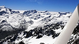
Murchison Glacier
| Murchison Glacier | ||
|---|---|---|
|
Murchison Glacier with Broderick Peak (2669 m) |
||
| location | New Zealand , South Island | |
| Mountains | New Zealand Alps | |
| Type | Valley glacier | |
| length | 15 km | |
| Altitude range | 2400 m - 1090 m | |
| width | ⌀ 0.7 km; Max. 1.5 km | |
| Coordinates | 43 ° 31 ′ S , 170 ° 24 ′ E | |
|
|
||
| drainage | Murchison River , Tasman Lake | |
The Murchison -Gletscher is a 15 km long glacier in Aoraki / Mount Cook National Park on the South Island of New Zealand .
geography
The Murchison Glacier has its origin in the approximately 7 km arching mountain range between Mount Abel ( 2688 m ) and Mount Mannering ( 2669 m ) in the New Zealand Alps and runs down the valley between the Malte Brun Range and the Liebig Range in a south-westerly direction. The glacier drains at the end of its glacier tongue in a constantly changing small glacial lake, from which the Murchison River is fed.
The Tasman Glacier runs west of the Murchison Glacier . Both have part of their origin on the Tasman Saddle, which is 2,435 m high .
Web links
- Murchison Glacier . GNS Science,accessed on October 3, 2014(English, photo of the Murchison glacier, which clearly shows the erosion taking place in the mountains).
- Murchison and Tasman Glaciers . Toni Baldwin (blog),accessed October 3, 2014(English, some photos of the Murchison glacier).

