Misso
| Misso | |||
|
|||
| State : |
|
||
| Circle : |
|
||
| Coordinates : | 57 ° 36 ' N , 27 ° 14' E | ||
| Area : | 189.9 km² | ||
| Residents : | 615 (2017) | ||
| Population density : | 3 inhabitants per km² | ||
| Time zone : | EET (UTC + 2) | ||
| Community type: | former rural community | ||
| Website : | |||

|
|||
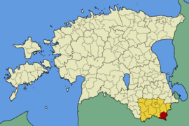
Misso (German: Illingen ) is a former rural community in the Estonian district of Võru with an area of 189.9 km². It had 615 inhabitants (January 1, 2017). Misso is located 38 km south-southeast of Võru .
During the 2017 municipal reform, the municipality was dissolved and divided between the rural municipalities of Rõuge and Setomaa . The largest part with the former capital Misso and the villages Häärmäni, Hino, Horosuu, Hürsi, Käbli, Kärinä, Kaubi, Kimalasõ, Kiviora, Korgõssaarõ, Kundsa, Kurõ, Laisi, Mauri, Missokülä, Möldre, Mursi, Pältre, Parmu, Pedejaski , Põnni, Sweater, Pupli, Rammuka, Rebäse, Ritsiko, Saagrimäe, Saika, Sakudi, Sandi, Sapi, Savimäe, Savioja, Siksälä, Suurõsuu, Tika, Tsiistre and Väiko-Tiilige came to Rõuge. The villages of Hindsa, Koorla, Kossa, Kriiva, Leimani, Lütä, Määsi, Mokra, Napi, Põrstõ, Pruntova, Saagri, Tiastõ, Tiilige, Toodsi and Tserebi came to Setomaa.
The lake-rich landscape is ideal for canoeing and hiking.

