
Natter starting points in Kirchheim / Teck

The Natter launch sites in Kirchheim / Teck are three launch ramps for the Bachem Ba 349 (“Natter”) rocket aircraft in the Hasenholz forest near Kirchheim unter Teck, which was never fully developed . Emergency fighters of the Natter type were to take off from these launch sites in 1945 as part of an “Operation Krokus” to repel enemy bomber groups.
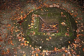
The three starting points are arranged roughly in the shape of an isosceles right-angled triangle, the cathets of which point towards the east and south. The mutual distance between the starting points is approx. 120 meters. You are at the coordinates 48 ° 37 ′ 42 ″ N , 9 ° 29 ′ 57 ″ E , 48 ° 37 ′ 42 ″ N , 9 ° 29 ′ 54 ″ E and 48 ° 37 ′ 40 ″ N , 9 ° 29 ′ 54 " O . The circular concrete slab on which the adder and the launch tower were supposed to stand is still preserved from all three launch sites. In the middle of each of these three concrete slabs has a square, approx. 50 centimeter deep hole to accommodate the launch tower. Next to this hole protrudes a pipe cut just above the ground, which was probably a cable duct.
The Natter launch sites in Kirchheim / Teck are likely to be the only remnants of rocket launch ramps from the Second World War that are publicly accessible in Baden-Württemberg. The former test site of the adder on the Ochsenkopf is located on the area of the Heuberg military training area and is therefore not accessible to the public.
Two of the starting points were removed in the course of the construction work for the new Wendlingen – Ulm line.
- Recordings of the starting points
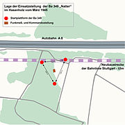
Site plan of the launch platform of the Ba 349 "Natter" in Hasenholz
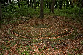
Starting point at the southern end of the triangle

Pick-up of the launch vehicle at the first launch site

Ba 349 "Snake" position in rabbit wood 3

Starting point at the northwest end of the triangle

The launch of the launch vehicle at the second launch site

Ba 349 "Snake" position in rabbit wood 2

Starting point at the eastern end of the triangle
The launch of the third launch site

Ba 349 "Snake" position in rabbit wood 1


Individual evidence
- ^ Monument dispute over three missile bases. ( Memento from September 10, 2012 in the web archive archive.today ) In: Filder-Zeitung , November 24, 2009.
Coordinates: 48 ° 37 ′ 41 ″ N , 9 ° 29 ′ 55 ″ E