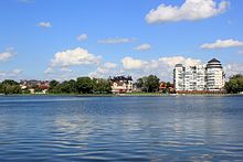
Oberteich (Kaliningrad)
The Oberteich ( Russian пруд Верхний / prud Verkhnij ) in Kaliningrad is 22 m above the Pregel and is about 41.1 hectares in size.
history
It was created in 1270 by knights of the Teutonic Order in Königsberg as a second reservoir and fish pond above the castle pond . Later, the surrounding green spaces were connected to the rose garden in the Maraunenhof villa district . The dam became Wrangelstrasse. On April 1, 1882, Oberteich was incorporated from the Königsberg district into the municipality and the Königsberg district.
Four “Fließe” (brooks) drained the Oberteich, three to the west and one to the east of the castle pond , and moved to the Pregel . They fed many public wells and pumps. The student flow and the mill flow were partly set in oak tubes and were extended to loach ponds for the ducal table in 1527 . They were boggy and had significant names for their stench, e.g. B. Lazy Pond and Black Sea . The Mühlenfließe was bought and filled in by the city in 1872. In 1903 the Katzbach was channeled and its old bed was filled up.
There were two bathing establishments at Oberteich: a military bathing establishment and the "civil bathing establishment". The Königsberg fraternity Gothia (located in Göttingen since 1949) had its corporation house on Oberteich.
The Oberteich today
Today the settlement “Jasnaja Poljana” is being built on the northern Oberteich. The lake is home to perch, roach, carp, tench, pike and eel.
During renovation work that has already been going on for five years, the seal sculptures created by Hermann Thiele and erected in 1913 were poorly repaired. A total of three billion rubles was spent on the beautification.
literature
- Erich Knoll: The reservoir group of the city of Königsberg, emerged from the mill water pipes of the Commandery of the Teutonic Knight Order. Deutsche Wasserwirtschaft 24 (1929), ISSN 0936-417X .
- Herbert Meinhard Mühlpfordt : Königsberg from A to Z. A city dictionary. Aufstieg-Verlag, Munich 1972.
Web links
- City of Königsberg (territorial.de)
- Kaliningrad: Own settlement for the elite at the Oberteich (Russland-Aktuell, 2008)
Individual evidence
- ^ Johannes Bobrowski : Der Mahner . In: Atlas. Compiled by German authors . Wagenbach, Berlin 1965, pp. 11–17, here p. 13.
- ↑ Preussische Allgemeine Zeitung / episode 15-12 of April 14, 2012
Coordinates: 54 ° 43 ′ 26 ″ N , 20 ° 31 ′ 9 ″ E


