Panama Canal Zone
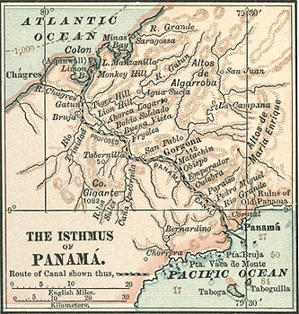
The Panama Canal Zone ( Spanish Zona del Canal de Panamá ; English Panama Canal Zone ) was a 1432 km² territory within Panama . It consisted of the Panama Canal and a strip of 5 miles (8.1 km) on each side of the canal route (except Panama City and Colón , which otherwise would have been partially in the area), as well as the total area of Lake Gatun . It was founded on November 18, 1903 with the signing of the Hay-Bunau-Varilla Treaty and placed the zone under the control of the United States (see relations between the countries ). When Madden Lake was created later to ensure the water supply to the locks, it was integrated into the zone. At the end of 1999 the zone returned to Panama.
From 1903 to 1979 the area was controlled by the United States , which built and financed the canal, and ruled by governors . In 1964, during the flag dispute between the USA and Panama , clashes between the US military and Panamanian protesters resulted in several people being killed.
In 1977, the canal's neutrality was agreed in the Torrijos-Carter treaties . From 1979 to 1999 the canal itself was under joint US-Panamanian control. On December 31, 1999, the sovereignty of the Canal Zone was completely transferred to Panama. The Panama Canal Authority (Autoridad del Canal de Panamá - ACP) has been responsible for the operation, administration and modernization of the canal .
Except in times of crisis or political tensions, Panamanians could freely enter the zone. Still, the 1903 treaty restricted their right to shop in the zone's stores to protect Panamanian retailers.
During US control of the Canal Zone, the area (except for the Canal itself) was primarily used for military purposes. Nevertheless, there were approximately 3,000 permanent civilians ( Zonians ). Military use by the United States ended when the zone returned to Panama. It has now become part of Panama's economic system and has become a tourist attraction, especially for watching cruise ships .
literature
- Gustavo A. Mellander, Nelly Maldonado Mellander, Charles Edward Magoon: The Panama Years. Editorial Plaza Mayor, Río Piedras, Puerto Rico 1999, ISBN 1-56328-155-4 , OCLC 42970390.
- Gustavo A. Mellander: The United States in Panamanian Politics: The Intriguing Formative Years. Interstate Publishers, Danville, Ill. 1971, OCLC 138568.
Web links
Coordinates: 9 ° 7 ′ N , 79 ° 43 ′ W


