Pedro Reinel
Pedro Reinel (* around 1464; † after 1542) was a Portuguese cartographer .
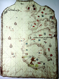
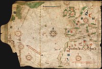
He produced the oldest signed nautical chart around 1485. This portolan shows parts of Western Europe, parts of Northwest Africa and also shows the discoveries of Diogo Cão from 1482 to 1485. Together with his son Jorge Reinel and the cartographer Lopo Homen , he contributed to the creation of the well-known Miller Atlas (1519). His Atlantic map is the first nautical chart with a scale and a wind rose .
Web links
| personal data | |
|---|---|
| SURNAME | Reinel, Pedro |
| BRIEF DESCRIPTION | Portuguese cartographer |
| DATE OF BIRTH | around 1464 |
| DATE OF DEATH | after 1542 |


