Polar Bear Provincial Park
|
Polar Bear Provincial Park
|
||
| location | Ontario (Canada) | |
| surface | 23552 km² | |
| WDPA ID | 4162 | |
| Geographical location | 55 ° 0 ′ N , 84 ° 0 ′ W | |
|
|
||
| Setup date | 1970 | |
| administration | Ontario parks | |
The Polar Bear Provincial Park , with an area of 23,552 square kilometers the largest park in the Canadian province of Ontario and also the northernmost.
Location and purpose
It is located on the west bank of Hudson Bay , where James Bay begins. It was founded in 1970 and is administered by Ontario Parks . Its main purpose is to protect the polar bear population that lives there , which includes around 200 animals. There are also Canadian forest caribou , moose , beavers , foxes , black bears and martens , as well as numerous species of birds such as Canada geese and other migratory birds . Seals , walruses and belugas live in and around Hudson Bay . Around 75% of the park is covered by wetlands, lakes or rivers. The largest lake measures 13 by 5 km and is a maximum of 3 m deep.
Except for by canoe, access is only possible by plane; a special permit is required to enter the remote park. Four landing strips serve the aircraft. During the Cold War, one of these landing sites was home to a radar station, which has numerous artifacts. Two camps of the local Indians, who are the only ones allowed to fish and hunt, are also open to visitors.
flora
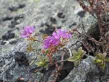
Since the last ice age, the land has increased by 1.2 cm per year due to the liberation from the enormous ice load. Until about 2000 BC The area was part of the Tyrrell Sea, a post-glacial lake whose retreat is today's Hudson Bay. The flat area has only a few hills that are remnants of former coastlines. Some of the flat, coastal areas are inundated every year when the ice melts. Mosses cover the barren, subpolar landscape, which only has trees in the west. There is also Rhododendron lapponicum . Crowberries and lingonberries also grow here. In the spring, numerous flowering plants color the landscape, to which thousands of small pools contribute, which change color depending on the minerals and microorganisms that are in them.
history
The park was created in 1967, initially on an area of 9400 km². The core area was the Cape Henrietta-Maria Wilderness Area. René Brunelle, the responsible Minister for Land and Forests, insisted that the indigenous people there were allowed to continue hunting and fishing. He provided background information in the Cree language and discussed with representatives of the Attawapiskat First Nation. Since there were no other employment opportunities in the region, only members of the local tribes were allowed to apply as guides in the park. Even the Federation of Ontario Naturalists, which opposed hunting in provincial parks, supported this principle. In the course of the 1970s, however, the attitude of the Cree and Anishinabe to the establishment of protected areas changed. They were in conflict with their ideas of independence, autonomy and self-sufficiency. The need for independence increased significantly, the understanding of a nation changed. The Nishnawbe-Aski First Nation found that their traditional concept of life in the land contradicted the concept of a remotely determined protection.
In 1992 it was discussed whether the park should be expanded. This affected the surrounding First Nations . The Indians fear that if raw materials are extracted, roads will be built first. They are followed by the establishment of townships and the measurement of the land, then the loss of freedom of movement, as every square meter is given an owner. This has to do with the fact that Ontario, like most provinces of Canada, gives the extraction of natural resources absolute priority, both over property rights and over indigenous rights protected by supreme courts. In this context, there have been violent disputes several times. In the case of the Polar Bear Provincial Park, however, Weenusk First Nation and the First Nations of Attawapiskat, Fort Severn and Peawanuck agreed that an expansion of the park would benefit them, as it seemed to them a suitable means of keeping out raw material exploration and protecting the area permanently .
literature
- Gerald Killan: Protected places: a history of Ontario's provincial parks system , Louiseville, Québec: Gagné Printing Ltd 1993.
Web links
- Polar Bear (Ontario Parks website)
Remarks
- ^ Lauchlan H. Fraser, Paul A. Keddy: The World's Largest Wetlands. Ecology and Conservation , Cambridge University Press 2005, pp. 133-136.
- ^ For example, Louis Bird, Jennifer SH Brown, Anne Lindsay, Paul Warren DePasquale: Telling our stories: Omushkego legends and histories from Hudson Bay , Broadview Press 2005, p. 229.
- ^ John Marsh, Bruce W. Hodgins: Changing Parks: the History, Future and Cultural Context of Parks and Heritage Landscapes , Winnipeg 1998, p. 68.

