
Punta del Diablo
| Punta del Diablo | ||
|---|---|---|
|
Coordinates: 34 ° 3 ′ S , 53 ° 32 ′ W Punta del Diablo on the map of Uruguay
|
||
| Basic data | ||
| Country |
|
|
| Department | Rocha | |
| Residents | 823 (2011) | |
| City insignia | ||
 |
 |
|
| Detailed data | ||
| Post Code | 27204 | |
| Website | ||
 |
||
.jpg) |
||

Punta del Diablo (translated Cape of the Devil ) is a seaside resort in the Rocha department in southeast Uruguay .
It is located 298 km from the capital Montevideo on the Atlantic coast. The Brazilian-Uruguayan border is around 40 kilometers northeast of the city of Chuy . The original fishing village, whose 389 inhabitants (as of 2004) mainly work as fishermen and artisans , is one of the most important tourist destinations on the coast of Uruguay. Due to its originality and its not very modern and sophisticated appearance, it represents the complete alternative to the chic Punta del Este , about 200 km away . Punta del Diablo can probably be described as a so-called dropout village . Nevertheless, it is very attractive to tourists from Argentina, Brazil and Europe and is a popular holiday destination among other things for surfers.
In the waters off Punta del Diablo there are also sea turtles, whose population is endangered.
Residents
In 2011 Punta del Diablo had 823 inhabitants, of which 448 were men and 375 were women.
Results of the census:
| year | Residents |
|---|---|
| 1963 | - |
| 1975 | - |
| 1985 | 199 |
| 1996 | 318 |
| 2004 | 389 |
| 2011 | 823 |
Source: Instituto Nacional de Estadística de Uruguay

Sunset in Punta del Diablo

Tortuga Verde at Punta del Diablo
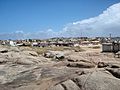
View of Punta del Diablo
.jpg)


Web links
- Official site of the city (Spanish)
- www.puntadeldiablo.com.uy (Spanish)
- City map of Punta del Diablo (PDF; 103 kB)