
Ramal de Balneario Ostend
| Ramal de Balneario Ostend (Argentina) Decauville de Ostend |
|||||||||
|---|---|---|---|---|---|---|---|---|---|
.jpg) O&K locomotive of the steam tram , March 1913
| |||||||||
 Route of the nearby railways
| |||||||||
| Route length: | 3 km | ||||||||
| Gauge : | 600 mm ( narrow gauge ) | ||||||||
|
|||||||||
The Ramal de Balneario Ostend or colloquially Decauville de Ostend was a 3 km long narrow-gauge railway through the dunes to the seaside resort of Ostend near Pinamar in Argentina , which was officially put into operation in 1913.
Location and history
The Ferrocarril del Sud has a 1908 stop named Estación Juancho taken on the property of José Guerrero, about 30 km from the sea in operation. The pioneers Ferdinand Robette from Belgium and Agustín Poli from Italy then acquired a 14 km² plot of land in the dune area between General Madariaga and Ostend, which was known as the Montes Grandes de Juancho . From 1909 a Belgian company headed by Ferdinand Robette worked on the ambitious project to develop the area in terms of town planning and to make it usable for tourism based on the example of European health resorts, for which Japanese workers who lived 1 km away were employed.
The Belgians called the place Ostend because it reminded them of the seaside resort on the North Sea. The elegant but not luxurious urbanization comprised a 50 m wide avenue, a hotel and a Kursaal as well as a promenade with columns and balustrades that was not finished and whose battlements can still be seen in the sand today.
In order to develop the area, they laid a flying track, a narrow-gauge railway that was ceremoniously put into operation in 1913 and operated with an O&K steam locomotive.

Start of the route in Colonia Tokyo
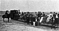
March 1913

April 1913

October 1914
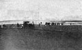
End of the line on the beach, March 1913
.jpg)

.jpg)
.jpg)
Individual evidence
- ↑ El 'Balneario Ostend' no es una promesa. Es una hermosa realidad - Los hechos lo confirman.
- ^ Gustavo Lopez: En tren, llega la modernidad.
- ^ Viejo Hotel Ostend, 100 Years of History.
Coordinates: 37 ° 7 ′ 30.7 ″ S , 56 ° 53 ′ 0.6 ″ W.