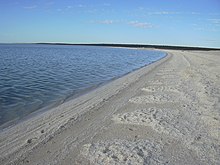
Shell Beach
The Shell Beach is a 40 km long coastline on the Western Australian Shark Bay , consisting of an up to 10 meter thick layer of billions of cockles the type Fragum erugatum there. It borders L'Haridon Bight on the northeast of the area's two large peninsulas, also known as the Peron Peninsula .
With the coasts of the Hamelin Pool Marine Nature Reserve south of the bay, which also has large areas of mussel beach, the length of Shell Beach is over 100 km.
Emergence
Fragum erugatum is so strongly represented in the waters of Shark Bay that wind and waves have washed up extraordinary amounts of shells in about 6000 years. Only on the first 3–4 m beach, which is closest to the sea, are the shells loosely piled up.
On the stretches of beach inland, which are no longer washed around by the water, the rain has loosened calcium carbonate from the shells and caused the mussels to "cement" firmly. The resulting biogenic sedimentary rock - called Coquina - was used as a building material until the 1950s. For this purpose it has mussel Quarries ( shell quarries ), in particular the establishment of the church and other buildings in Denham given. In 1990 the Shark Bay Marine Park (7,487 km²) and the adjoining Hamelin Pool Marine Nature Reserve (1,320 km²) were established and the mussel beaches were declared protected areas. A show quarry has been reconstructed at the Hamilton Pool; the removal of the rock is prohibited.
Access
Large sections of Shell Beach, which circles the 20 km long peninsula between L'Haridon Bight and Hamelin Pool with Cape Petit Point , are inaccessible through dense acacia bushes from Denham-Hamelin Road , the only connection road from the mainland through the peninsula Denham and Monkey Mia , separated.
There are only two access roads from this through route:
- At Nanga (gas station and supply station) at the narrowest point on the peninsula (picnic area, hiking trail, information board) and
- at the Hamelin Telegraph Station ( Coquina documentation trail to a colony of stromatolites , which are among the oldest forms of life on earth).
literature
- Günther, Janine / Mohr, Jens: Westaustralien und das Top End, Verlag 360 °, 1st edition 2005
Web links
- Shell Beach in Australia's Coral Coast Portal
- Shell Beach at Australias.Guide
Coordinates: 26 ° 12 ′ 38.9 ″ S , 113 ° 45 ′ 51.4 ″ E


