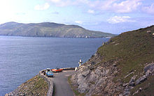
Slea Head

Slea Head ( Irish : Ceann Sléibhe , dt. 'Mountain peak') is a headland in the westernmost Gaeltacht part of the Dingle Peninsula in the southwest of County Kerry in Ireland . The prominent point belongs to the province of Munster and is located on Slea Head Drive ( R559 ), an approx. 47 km long circular route on the peninsula. The nearest villages are Baile Ícín (Ballyickeen) and Com Dhíneol (Coumeenoole).
A white crucifix depicting Jesus Christ and Mother Mary marks a vantage point that offers a wide view of Dingle Bay and the Blasket Islands .
On March 11, 1982, the recently completed Spanish container ship Ranga was destroyed in a storm on its maiden voyage from Santander to Reykjavík and went down at nearby Dunmore Head .
Individual evidence
- ↑ Travelogue "Dingle and Slea Head" , derostours.com, accessed on May 13, 2014
- ↑ Rick Steves. Dingle Peninsular Loop Trip. From: smithsonianmag.com, April 2009, accessed April 11, 2016
- ^ Slea Head and Dunmore Head , Heiko Streich, accessed May 13, 2014
- ↑ Data of the shipwreck , naufragio.eu, MV Ranga +1982, accessed 13 Main 2014
Coordinates: 52 ° 5 ′ 52.8 " N , 10 ° 27 ′ 18" W.

