Storegga

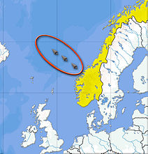
As Storegga (Norwegian: large edge ), the continental slope in the European North Sea off the Norwegian coast on the southern Vøring Plateau referred below which has formed far-reaching into the North Atlantic rubble and mud heap extended by repeated landslides over the millennia a .
Dating
The Storegga slide , also known as the Storegga event , took place in several phases about 8200 years ago (7250 ± 250 14 C yrs BP ) according to radiocarbon dating , with the majority of the slide mass being mobilized during the first slide event.
event
The landslides are associated with the progressive destabilization of gas hydrates , especially methane hydrate . A major slide event with the shelf edge breaking off can lead to a tsunami . As a result of the Storegga landslide, tsunam-inherent deposits can still be found on the Atlantic coasts in Northern Europe: On the Norwegian coast, the tidal wave was at least 10-12 meters above sea level. Also on the Shetland Islands , a tidal wave more than 20 meters high was detected on the basis of deposits. The sinking of the Dogger Bank , the last island left from Doggerland , was completed in the process. Depending on the region in which such large submarine slides occur, the resulting tidal waves can cause considerable damage to coasts.
With a length of over 800 km and a volume of around 5600 km³, it is one of the largest landslides known worldwide .
literature
- BJ Coles: Doggerland's Loss and the Neolithic . In: B. Coles, J. Coles, M. Schou Jorgensen (Eds.): Bog Bodies, Sacred Sites and Wetland Archeology, 12th Department of Archeology, University of Exeter: WARP (Wetland Archeology Research Project) Occasional Paper 1999, p 51-57.
- Bernhard Weninger, Rick Schulting, Marcel Bradtmöller, Lee Clare, Mark Collard, Kevan Edinborough, Johanna Hilpert, Olaf Jöris, Marcel Niekus, Eelco J. Rohling, Bernd Wagner: The catastrophic final flooding of Doggerland by the Storegga Slide tsunami. In: Documenta Praehistorica. Vol. 35, 2008, doi: 10.4312 / dp.35.1 .
Individual evidence
- ^ H. Haflidason, R. Lien, HP Sejrup, CF Forsberg, P. Bryn: The dating and morphometry of the Storegga Slide. In: Marine and Petroleum Geology. B. 22, No. 1-2, 2005, pp. 123-136, doi: 10.1016 / j.marpetgeo.2004.10.008 (alternative full text access : ResearchGate ).
- ↑ Jürgen Mienert, Maarten Vanneste, Stefan Bünz, Karin Andreassen, Haflidi Haflidason, Hans Petter Sejrup: Ocean warming and gas hydrate stability on the mid-Norwegian margin at the Storegga Slide. In: Marine and Petroleum Geology. Vol. 22, No. 1–2, 2005, pp. 233–244, doi: 10.1016 / j.marpetgeo.2004.10.018 .
- ↑ Bernhard Weninger, Rick Schulting, Marcel Bradtmöller, Lee Clare, Mark Collard, Kevan Edinborough, Johanna Hilpert, Olaf Jöris, Marcel Niekus, Eelco J. Rohling, Bernd Wagner: The catastrophic final flooding of Doggerland by the Storegga Slide tsunami. In: Documenta Praehistorica. Vol. 35, 2008, doi: 10.4312 / dp.35.1 .
- ↑ a b M. Latif: Climate Change and Climate Dynamics . Ulmer Verlag, 2009, p. 180 f.
Coordinates: 64 ° N , 0 ° E


