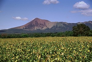
Telica
| Telica | ||
|---|---|---|
|
Telica (1998) |
||
| height | 1061 m | |
| location | Department of León , Nicaragua | |
| Coordinates | 12 ° 36 '7 " N , 86 ° 50' 42" W | |
|
|
||
| Type | Stratovolcano | |
| Last eruption | 2011 | |
Telica is a 1061 m high active volcano in Nicaragua .
Location and surroundings
The Telica is 15 kilometers east of León . To the southeast are the El Liston volcano and the Hervideros de San Jacinto geothermal area .
The volcanic complex consists of several interconnected cones, most of which are arranged in a north-west-south-east direction. In the steep main cone there is a double crater with a diameter of 700 meters and a depth of around 120 meters.
Volcanism
The Telica is considered one of the most active volcanoes in Nicaragua. Numerous eruptions have been recorded since the time of the Spanish conquest. Reports of an eruption of the Santa Clara Crater in the southwest of the volcanic complex from the 16th century also in reality refer to the Telica from today's perspective.
In May 2011 the volcano erupted for the first time since 1948. The eruption was accompanied by an earthquake and a 1.2-kilometer-high ash cloud, around 60 villages in the area had to be evacuated.
Web links
- Telica in the Global Volcanism Program of the Smithsonian Institution (English)
Individual evidence
- ↑ a b c Telica in the Global Volcanism Program of the Smithsonian Institution , accessed February 14, 2012
- ↑ Strong explosions in the Telica volcano , Abendblatt.de of May 19, 2011, accessed on February 14, 2012


