Thematic mapper
The Thematic Mapper ( TM ) is an opto-mechanical system supported by the Landsat-4 and -5 satellites for the acquisition of remote sensing data in the research area of remote sensing , the Enhanced Thematic Mapper (ETM +) is the extension of Landsat-7 .
Spatial resolution
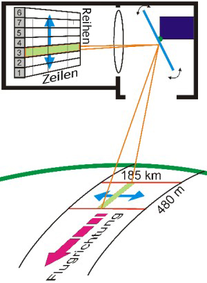
The system is based on an arrangement of 100 spectral detectors that use an oscillating mirror to record the signals reflected from the earth's surface. For the spectral channels 1 to 5 and 7, 16 spectral detectors per channel form a scanning row. For channel 6 there are 4 detectors per row. Approximately 6300 measurements are carried out per mirror rotation. One line corresponds to 185 kilometers on the earth's surface (185 km / approx. 6300 measurements = 30 meters per pixel in the line).
A scan row consists of 16 detectors and maps 480 meters, which results in 30 meters per pixel in the row. One pixel of channels 1-5 and 7 depicts the radiation intensity of an area of 30 meters × 30 meters. One pixel of the TIR channel 6 maps the radiation intensity over an area of 120 meters × 120 meters.
Spectral resolution
| channel | Type of radiation | Wavelength (µm) | application |
|---|---|---|---|
| 1 | blue | 0.45-0.52 | Differentiation of soil, water and vegetation |
| 2 | blue-green + green-yellow | 0.53-0.61 | Vegetation on land and in the water |
| 3 | orange + red | 0.63-0.69 | Differentiation of plant species, separation of soil types, minerals |
| 4th | Near infrared | 0.78-0.90 | Biomass, coastlines, urbanization |
| 5 | Short wave infrared | 1.57 - 1.78 | penetrates haze, differentiation of plant species and rock types |
| 6th | Thermal infrared | 10.42-11.66 | Thermal radiation, measuring more of heat differences than exact temperatures |
| 7th | Short wave infrared | 2.10-2.35 | Water content of plants, soils |
Enhanced Thematic Mapper (ETM)
Landsat-6 was equipped with an ETM that was not used because the satellite was lost. The ETM + system from Landsat-7 has only been delivering high-resolution data within a strip of 25 km width since 2003 due to a mechanical problem. In addition to TM, ETM had a panchromatic band of 0.5–0.9 µm with 15 m spatial resolution (band 8), ETM + had a spatial resolution of 60 m in the thermal band. The following channels are available for ETM + (wavelengths in µm): 0.45–0.52, 0.52–0.60, 0.63–0.69, 0.76–0.90, 1.55– 1.75, 2.08-2.35 with 30 m resolution, 10.4-12.5 ( thermal band ) and a panchromatic band 0.5-0.9 with 15 m spatial resolution (band 8).
Radiometric resolution
The TM detectors have a resolution of 8 bits for displaying 256 gray levels.
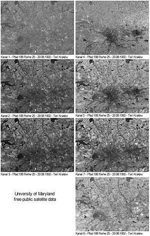
The sequence of images on the right shows data excerpts from the seven channels of remote sensing data from the Thematic Mapper of the Landsat 4 and Landsat 5 satellites. The image section shows the Polish city of Krakow and its surroundings. The original data sets of the seven channels of the Thematic Mapper have a data volume of around 450 megabytes.

