Tortuga (Mexico)
| Isla Tortuga | ||
|---|---|---|
| The Isla Tortuga | ||
| Waters | Gulf of California | |
| Geographical location | 27 ° 26 '35 " N , 111 ° 52' 48" W | |
|
|
||
| length | 4.7 km | |
| width | 3.3 km | |
| surface | 11.374 km² | |
| Highest elevation | 210 m | |
| Residents | uninhabited | |
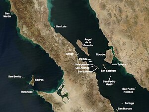
| Gulf of California island map | ||
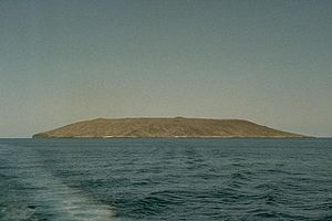
The Isla Tortuga is a small Mexican island of volcanic origin in the Gulf of California 40km off the coast of Baja California .
The island is a 210 m high shield volcano with a 1 km wide and 100 m deep caldera that was formed geologically recently in the Holocene on the East Pacific Ridge . The time of the last outbreak is unknown. The island is 4.7 km long and a maximum of 3.3 km wide, with an area of 11.374 km².
Since 2005, the island has been a UNESCO World Heritage Site along with 243 others in the Gulf of California . The next place on the coast is the old mining town of Santa Rosalía , administrative seat of the Municipios Mulegé .
Web links
- Tortuga (Mexico) in the Global Volcanism Program of the Smithsonian Institution (English)
- Isla Tortuga Volcano
- San Carlos TV: Video
Individual evidence
- ↑ Hubert Fabriol, Luis A. Delgado Argote, Juan José Dañobeitia, Diego Cordoba, Antonio González, Juan Garcıa-Abdeslem, Rafael Bartolome, Beatriz Martin-Atienza, Victor Frias Camacho: Backscattering and geophysical features of volcanic ridges offshore Santa Rosalia, Baja California Sur, Gulf of California, Mexico . In: Journal of Volcanology and Geothermal Research . tape 93 , no. 1-2 , 1999, pp. 75-92 , doi : 10.1016 / S0377-0273 (99) 00084-0 .
- ↑ Iles et aires protégées du Golfe de Californie


