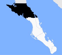
Municipio Mulegé
| Mulegé | ||
|---|---|---|

|
||
| Symbols | ||
|
||
| Basic data | ||
| Country | Mexico | |
| State | Baja California Sur | |
| Seat | Santa Rosalía | |
| surface | 32,111.9 km² | |
| Residents | 59,114 (2010) | |
| density | 1.84 inhabitants per km² | |
| Website | ayuntamientomulege.gob.mx | |
| INEGI no. | 03002 | |
| politics | ||
| Presidente municipal | José Felipe Prado Bautista | |
Coordinates: 27 ° 0 ′ N , 112 ° 30 ′ W
Mulegé is a municipality in the Mexican state of Baja California Sur . The municipality has 59,114 inhabitants (2010 census), its area amounts to 32,112 km². The administrative seat is Santa Rosalía , namesake is the place Heroica Mulegé , while the most populous place of the municipality is Guerrero Negro .
geography
The municipality of Mulegé is located in the north of the state of Baja California Sur at an altitude of up to 1900 m . It extends from the border between Baja California and Baja Californis Sur near Guerrero Negro in the north to just before the city limits of Loreto in the south. It belongs entirely to the physiographic province of the Baja California peninsula . The geology of the municipality consists of around 35% extrusive rock , around 28% sedimentary rock , 21% aeolian sediment and 8% alluvion . The predominant soil types are the Regosol (38%) and Leptosol (27%). More than 90% of the community area is covered by scrub landscape.
The municipality is bounded by the municipality of Loreto and Comondú , the state of Baja California , the Gulf of California and the Pacific . The municipality also includes the islands of San Marcos and Tortuga in the Gulf of California and Isla Natividad in the Pacific.
population
According to the 2010 census, the municipality has 59,114 inhabitants in around 16,500 residential units. Of these, 3,037 persons were identified as speakers of indigenous languages recorded, including 780 speakers of Nahuatl and 589 speakers of Mixtec . About 5.8% of the population were illiterate. 26,117 inhabitants were registered as economically active, of which approx. 69% were men or 2.1% were unemployed. 5.6% of the population lived in extreme poverty.
Places and structure
The municipality of Mulegé comprises 459 inhabited localidades , of which the INEGI, in addition to the main town, also classifies Guerrero Negro, Villa Alberto Andrés Alvarado Arámburo, Heroica Mulegé and Bahía Tortugas as urban. In the 2010 census, three places had a population of over 5,000, 13 other places had at least 500, and more than 400 places had fewer than 100 inhabitants. The biggest places are:
| place | population |
| Guerrero Negro | 13,054 |
| Santa Rosalía | 11,765 |
| Villa Alberto Andrés Alvarado Arámburo | 6,902 |
| Heroica Mulegé | 3,821 |
| Bahía Tortugas | 2,671 |
| San Francisco | 2.152 |
| Las margaritas | 1,595 |
| Bahía Asunción | 1,484 |
| El Silencio | 1,190 |
| Gustavo Díaz Ordaz | 969 |
| Estero de la Bocana | 967 |
| Punta Abreojos | 788 |
| San Ignacio | 667 |
| Los Martires | 651 |
| San Bruno | 623 |
| Ejido San Lucas | 606 |
The administrative district is further subdivided into seven delegaciones .
Web links
- Enciclopedia de los Municipios y Delegaciones de México: Municipio Mulegé (Spanish)
- INEGI : Datos Geográficos: Municipio Mulegé (Spanish; PDF)


