Mulegé
| Heroica Mulegé | ||
|---|---|---|
|
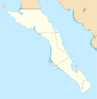
Coordinates: 26 ° 54 ' N , 111 ° 59' W Heroica Mulegé on the map of Baja California Sur
|
||
| Basic data | ||
| Country | Mexico | |
| State | Baja California Sur | |
| Municipio | Mulegé | |
| Residents | 3821 (2010) | |
| Detailed data | ||
| height | 16 m | |
| Street in Mulegé | ||
| Mission Santa Rosalía | ||
| Oasis near Mulegé | ||
Mulegé ([ mu.le.ˈhe ], officially Heroica Mulegé ) is a city in the Mexican state of Baja California Sur with 3821 inhabitants (2010 census) . It is located about 60 km south of Santa Rosalía .
history
The river valley of today's Mulegé was discovered in 1702 by the Jesuit Father Juan María de Salvatierra as a place for a mission, and thus for a settlement.
As everywhere in Central and South America , it was the Spanish conquistadores and, associated with them, the church order bearers who set up missions and settlements. The valley of the river, which was still unnamed at the time, was predestined for a settlement because of the water available. Mulegé is just 2 km from the ocean.
In 1754, Father Francisco Escalante began building the Mission Church, now known simply as "Mission". Later on, numerous Spanish missionaries came to what is now Mulegé to convert the hinterland to Catholicism.
Officially, Mulegé is allowed to call himself Heroica Mulegé . This title goes back to the American-Mexican War of 1846–1848. General Santa Ana besieged the famous Alamo fortress in San Antonio (Texas) and took it. In return, the troops of the United States tried to conquer the entire Baja California peninsula for the United States. They besieged Mulegé. The residents of Mulegé and the surrounding villages routed the US Army. Mulegé was not conquered. As a reward for this defense, Mulegé received the official title of Heroica Mulegé .
Attractions
- Sights include the Mission Santa Rosalía de Mulegé, founded in 1705.
- The cave paintings of the Sierra de Guadalupe near Mulegé are also among the sights. The images in the caves are very rich and can also be found in the Sierre de San Borjita and La Trinidad.
- A special feature in Mulegé is the old prison. Built in 1907, it was created without any lattice. The prisoners were able to move around freely and only had to appear again in the evening. Escape attempts were rare, the MEX 1 state road did not yet exist. In addition, all prisoners had undertaken to track down and bring back refugees. The prison is now a museum.
economy
Mulegé is known for its rich fishing grounds in the Mar de Cortés ( Gulf of California ), named after the Spanish conqueror Hernán Cortés . On the coast off Mulegé in the Gulf of California, a cold current from the north and a warm current from the south (Pacific) come together and create an almost incomparable abundance of fish. The fishing industry of the locals and deep sea angling of the tourists is one of the economic bases in Mulegé. Of course there is considerable tourism associated with deep-sea fishing.
It was not until 1976 that the MEX 1 state road reached Mulegé. Until then, only a dirt road led from the US state border in the north to the southern tip of the peninsula. A truck trip from Tijuana (border town on the border with the USA) to Mulegé, which today takes around 12 hours, took up to 4 days before 1976. Mulegé was mainly reached by sea. Until 1976, the population around Mulegé was mainly from their own crops and the fishing industry.
Climate and Cultivation
Although Baja California is one of the areas with the lowest rainfall in the world over its entire length of over 1,600 kilometers, Mulegé is an exception. Mulegé is located on the Río de Santa Rosalía , which supplies the region around Mulegé with water. The region owes its abundance of plant growth to the water resources with all kinds of palms and bananas , lemons , limes and oranges , mangoes and all kinds of vegetables known from Europe. Cauliflower, spinach and carrots, to name just a few, thrive in the Mulege region. The soil in this region is very fertile.
particularities
- The administrative district of Mulegé extends from the city limits of Guerrero Negro about 250 km north of Mulegé to about 60 km south of Mulegé. The district government is based in Santa Rosalía .
- The mission in Mulegé is called Misión Santa Rosalía . The mission in Santa Rosalía, however, is called Santa Bárbara .
- The river through Mulegé is officially called Río Santa Rosalía (popularly also Río Mulegé ).
Individual evidence
- ^ Catálogo de Localidades. Retrieved December 25, 2016 .


