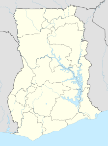
Yeji (Ghana)
Coordinates: 8 ° 14 ′ N , 0 ° 39 ′ W
Yeji is a village in the Bono East region in Ghana with almost 19,000 inhabitants (as of 2000).
Originally the old settlement was further to the west, but had to be relocated due to the rising water as a result of the Volta Lake dammed by the Akosombo Dam . Today Yeji is one of the inland sea ports on Lake Volta and a port of call for trading goods.
Meanwhile, some tourists use Yeji as a stopover after Tamale or linger in Yeji, where there are few water sports and because of the abundance of fish there are good prospects when fishing.
Population development
The following overview shows the population by area since the 1970 census.
| year | Residents |
|---|---|
| 1970 | 5,485 |
| 1984 | 11,144 |
| 2000 | 18,593 |
Transport links
The ferries from Akosombo in the south and Buipe in the east stop in Yeji . There is also an expressway going south to Ejura and Kwadjokrom . There are daily bus connections and individual Tro-Tro connections to Kumasi . A passenger boat or car ferry takes you to the opposite bank of Lake Volta, to Makongo , from where the journey to northern Ghana (e.g. to Tamale ) can be continued.
literature
- Jojo Cobbinah: Ghana. Practical travel guide for the 'Gold Coast' of West Africa . PMV Peter Meyer Verlag, ISBN 3-89859-115-8 .
Individual evidence
- ↑ Ghana: Regions & Cities - Population Statistics, Maps, Charts, Weather and Web Information. Retrieved June 28, 2019 .

