
Zurmaien
Zurmaien (formerly also: Zurmayen and Zur Mayen, and before that: ad Remigium) was an estate and living space that is now part of the Trier district of Trier-Nord .
history
Presumably from the second half of the 6th century at the latest, the chapel of St. Remigius was located here . There was a settlement of fishermen and boatmen on the banks of the Moselle near the chapel, and a settlement on Remigium is also mentioned. On September 25, 1552, the chapel, along with other buildings such as that of its owner, the St. Maximin Abbey, was destroyed by the troops of Margrave Albrecht Alcibiades of Brandenburg-Kulmbach . The chapel was also called "Sent Remey". The place names “Zur Remey” and “Zur Meien” later became the name “Zurmaien”.
Since the Middle Ages, Zurmaien has been an estate of the St. Maximin Abbey . Until an administrative reform in 1801, Trier was divided into sovereign territories. Zurmaien belonged here as an exclave to the Maximinischen sovereignty and was then assigned to the new district Zurlauben. The use of the abbey as an estate ended in the course of secularization in 1802. In 1805, the later government councilor Jacob Christian Schmeltzer bought the property and managed it himself. He carried out a renovation in the first half of the 19th century. The estate remained in the family until 1897, when it was sold to the United Hospitien . Zurmaien was in their possession until 1905 (some parcels belonging to it even longer). In 1905 the Trier rowing company bought the property. At the time of purchase, the property consisted of the main house, farm buildings (stables and coach houses), a park and an orchard. The rowing society used the building as a clubhouse or boathouse and converted the interior of the building for this purpose.

In 1913 part of the property was sold to the "Baugesellschaft Zurmayen", which had apartments built in the form of four semi-detached houses and two single houses. The buildings stretched along the corner of Zurmaiener Strasse and Maarstrasse (today: at the youth hostel). Two pavilions that stood at the entrance to the original property were demolished due to the construction project. A passage was integrated into the building at Zurmaiener Straße 30/32. The settlement was referred to as "settlement Zurmayen".
The construction of Neue Zurmaiener Straße (today: Ascoli Piceno Straße) in the mid-1960s cut through the site and a semi-detached house and the buildings of the former estate were demolished. Three of the semi-detached houses and one single house on Zurmaiener Straße and a single house on today's “An der Jugendherbege” street are still preserved today. The rowing company with a new boathouse that was inaugurated in 1964 is still based on the remaining property. An old plane tree on this property has been preserved and is listed as a natural monument.
Development of the area
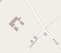
Situation in 1900
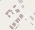
Situation in 1939
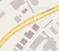
Situation in 2016


literature
- Carl Bittmann: Jacob Christian Schmeltzer and the Achard'sche Departements-Zuckerfabrik in St. Agnetenkloster in Trier, Anno 1811-14, in: Trierisches Archiv, supplement II, Trier 1901.
- Heinz Cüppers: The northern burial ground and its buildings in Roman times, in: Römisch-Germanisches Zentralmuseum Mainz (ed.): Guide to prehistoric and early historical monuments, Volume 32 Trier, Mainz 1977.
- Heinz Cüppers et al .: The United Hospices in Trier, Trier 1980.
- Wolfgang Jungandreas: Zurlauben and Zurmaien, in: Trierische Landeszeitung, edition April 16, 1960.
- Wolfgang Jungandreas: Historical lexicon of settlement and field names in the Moselle region, Trier 1962.
- Gottfried Kentenich: History of the City of Trier, Trier 1915.
- Hans-Hermann Reck: The city expansion of Trier, Trier 1990.
- Rowing Society Trier 1883 e. V. (RGT) (Ed.): 100 years of RGT, Trier 1983.
Individual evidence
- ↑ Jungandreas 1961, p. 1161
- ↑ Cüppers 1977, p. 82
- ↑ Kentenich, p. 360
- ↑ Jungandreas 1960, o. P.
- ^ Reck, p. 445
- ^ Reck, p. 265
- ↑ Bittmann, p. 77
- ^ Reck, p. 224
- ↑ Bittmann, p. 77
- ↑ Zenz in Cüppers et al., P. 92
- ↑ Zenz in Cüppers et al., P. 97
- ↑ RGT, p. 19 f.
- ↑ RGT, p. 20 f.
- ^ Reck, p. 446
- ^ Reck, p. 274
- ^ Reck, p. 339
- ↑ RGT, p. 74
- ↑ Landscape information system of the Rhineland-Palatinate Nature Conservation Administration: The natural monuments in Rhineland-Palatinate, archived copy ( memento of the original from November 24, 2015 in the Internet Archive ) Info: The archive link has been inserted automatically and has not yet been checked. Please check the original and archive link according to the instructions and then remove this notice. (Number: ND-7211-490)
Coordinates: 49 ° 46 ′ 0.6 ″ N , 6 ° 38 ′ 22.4 ″ E