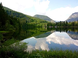
Ödensee
| Ödensee | ||
|---|---|---|

|
||
| Ödensee in July 2019 | ||
| Geographical location | Styria , Austria | |
| Tributaries | underground, intermittent flumes | |
| Drain | Ödensee-Traun (Seisenbach) | |
| Data | ||
| Coordinates | 47 ° 33 '40 " N , 13 ° 49' 15" E | |
|
|
||
| Altitude above sea level | 779 m above sea level A. | |
| surface | 19.92 ha | |
| length | 660 m | |
| width | 250 m | |
| Maximum depth | 19 m | |
|
particularities |
European (FFH) and nature reserve , swimming lake |
|
The Ödensee is a natural lake in the Salzkammergut . It is located in Pichl-Kainisch , in the municipality of Bad Mitterndorf , in Styria at 776 m.
Hydrography and Nature
What is striking about this lake is the largely underground inflow and some intermittent channels. The Ödenseetraun (Seisenbach) drain flows into the Traun in Bad Aussee .
The Ödensee has a maximum depth of about 19 m. Although it is one of the smaller lakes in the Salzkammergut with an area of almost 20 hectares, it is also one of the colder ones. This can be explained by the meltwater from the Kemet Mountains (part of the Dachstein Mountains ). Nevertheless, it is a regionally popular swimming lake in summer.
The Waldmoorsee with its environment in the basin as a European nature reserve ( FFH , AT2206000 , 203.5 ha) as well as a nature reserve ( NSa 5 , 203.5 ha) Ödensee reported. It is also located in the Salzkammergut-West landscape conservation area ( LS 14b ). The UNESCO World Heritage Site Hallstatt-Dachstein / Salzkammergut begins about one kilometer to the west.
The lake is populated by: rainbow trout , lake trout , brown trout , char , pike , whitefish and carp .
Web links
- Ödensee nature experience (naturerlebnis-oedensee.at)
- Ödensee , Styrian Tourism › Bathing lakes
- Entry on Ödensee in the Austria Forum , author / editing: Hilde and Willi Senft, knowledge collection: A selection from the most beautiful lakes in Austria

