
Bad
| Bad | ||
 |
||
| Data | ||
| Water code | DE : 2152 (with Oberer Argen) | |
| location |
Baden-Württemberg
|
|
| River system | Rhine | |
| Drain over | Lake Constance → Rhine → North Sea | |
| confluence | the right Lower and the left Upper Argen between Neukirch and Wangen-Neuravensburg 47 ° 39 '17 " N , 9 ° 44' 40" E |
|
| Source height | 489 m above sea level NHN | |
| muzzle | between Kressbronn and Langenargen in Lake Constance Coordinates: 47 ° 35 ′ 14 ″ N , 9 ° 33 ′ 19 ″ E 47 ° 35 ′ 14 ″ N , 9 ° 33 ′ 19 ″ E |
|
| Mouth height | 395 m above sea level NHN | |
| Height difference | 94 m | |
| Bottom slope | 4 ‰ | |
| length | 23.4 km (with Unterer Argen approx. 93 km) | |
| Catchment area | 655.1 km² | |
| Discharge at the Gießen A Eo gauge : 639 km² Location: 5.8 km above the mouth |
NNQ (09/28/1949) MNQ 1933/2009 MQ 1933/2009 Mq 1933/2009 MHQ 1933/2009 HHQ (01/03/1948) |
1.93 m³ / s 4.58 m³ / s 19.4 m³ / s 30.4 l / (s km²) 233 m³ / s 474 m³ / s |
| Discharge at the mouth (natural discharge) A Eo : 655.1 km² |
MNQ MQ Mq MHQ |
4.28 m³ / s 19.54 m³ / s 29.8 l / (s km²) 231.8 m³ / s |
| Left tributaries | Obere Argen (main source river), Wielandsbach, Dorfbach (Betznau) | |
| Right tributaries | Lower Argen , Bollenbach | |
 |
||
The Argen is a river in Württemberg Baden- Bodenseekreis between the municipalities Kressbronn and Langenargen from the northeast in the Lake Constance opens. As a tributary of the Rhine , it is the third largest tributary of Lake Constance with an average water flow of around 20 m³ / s.
It arises from the source rivers Obere Argen (from the left; 7 m³ / s; 50 km long) and Untere Argen (from the right; 11 m³ / s; 69 km long) rivers in Bavaria . The Lower Argen is the much richer of the two source rivers and thus hydrographically the main upper reaches of the Argen. However, contrary to the convention, it shares its official water body identification number (GKZ) 2152 with the smaller Upper Argen, while the Lower Argen, qua its GKZ 21522, is understood as a tributary upper course. Calculated from the confluence at Neuravensburg in the Ravensburg district, the Argen itself is still 23.4 kilometers long.
In March 2014, the Argen was named “ River Landscape of the Years 2014/15 ”.
geography
Source rivers
Lower evil
The Untere Argen arises from the confluence of the Börlasbach and the Stixnerbach at about 850 m above sea level. NHN at the western entrance to Missen in the Bavarian Allgäu, from where it initially flows in a northerly direction to Isny in the Allgäu . There she experiences a change of direction to the northwest and at Waltershofen to the southwest. Behind Primisweiler it unites with the Upper Argen . The most important tributaries are the Wengener Argen , which is added to the right in its upper reaches, and the Haslach, which comes from the north and also meets the Argen shortly after Primisweiler . It is crossed several times by the A 96 .
Upper evil
The Obere Argen rises in a swampy area northwest of Oberstaufen in the Allgäu. It then flows through the gorge-like Eistobel near Grünenbach , where it forms several small waterfalls and cataracts . From the Argentobel Bridge the valley widens again. The Obere Argen flows through the large district town of Wangen im Allgäu and meets the Untere Argen below the Neuravensburg district . Their valley previously formed the northern edge of Wangen's development.
Course as bad

The valley of the Argen is initially deeply cut into the terrain, which is reflected in place names such as Gitzensteig . In the further course the valley floor becomes wider and offers the places Laimnau , Apflau and Badhütten space.
In the lower part of the lower reaches the Argen was severely straightened. Backwaters no longer exist due to the intensive agricultural use of the valley. As part of renaturation measures , several concrete barrages were replaced by slides . The deposited gravel near the mouth of Kressbronn is extracted in large quantities. This creates new bodies of water in the form of quarry ponds. The lower reaches of the Argen are provided with dams on both sides to protect against flooding. It is possible to use kayaks , bathing facilities are available.
The confluence with Lake Constance is flanked on both sides by harbors for sports boats, there are also campsites and other excursion and leisure facilities.
Tributaries and branches
Tributaries of the Argen from their confluence downwards. Length and catchment area where indicated according to the official waterway map.
- Lower Argen , right upper course
- Upper Argen , left upper course
- (Bach coming from Neukirch), from the right at Neukirch - Goppertsweiler , 2.9 km
- (Inflow at Blumegg), from the right to Neukirch-Blumegg, 2.0 km
- Regnitzgraben , from the left at Achberg -Regnitz, 0.4 km
- Tobelbach , from the left at Achberg-Frauenreute, 1.3 km
- (Brook from near Oberlangensee), from the right at Neukirch-Summerau, 1.8 km
- (Stream from the Langmoosweiher wetland), from left to Tettnang - Heggelbach , 2.1 km
- Steinenbach , from the right at Tettnang- Steinenbach , 1.1 km and km²
- Oberlangnauer Bach or Tobelbach, from the left at Tettnang- Oberlangnau , 2.2 km
- Rappenweiler Bach , from the right across from Tettnang- Unterlangnau , 2.8 km
- Langenesch , from the left, 1.0 km
- Sägebach or Eggesch, from the left, 1.1 km
- Bollenbach , from the right at Tettnang- Laimnau , 9.2 km and 31.2 km²
- Wielandsbach , from the left near Kressbronn am Bodensee - Gießen , 5.7 km and 4.3 km²
- → (exit of the Mühlbach), to the right before Langenargen - Oberdorf , 3.3 km
before Langenargen flows into the Mühlkanal Langenargen a little after its exit - → (exit of the Mühlkanal Langenargen), to the right, 2.9 km and 5.1 km², flows
into Lake Constance in Langenargen about one kilometer northwest of the Argen itself
Geological history of the Argen
Originally to the Danube


When Eishöchststand the Würm glaciation eastern meltwater flowed the Argen-tongue of the Rhine glacier of the Danube to. Soon, however, the water could no longer take its path via Friesenhofen , which was blocked by alluvial fans , and had to look for a new course westwards in front of the Menelzhofer Berg. This early Untere Argen still flowed - now via the Kißlegg reservoir on a detour - via today's Aitrach valley into the Iller to the Danube. An early Obere Argen made its way over the Rutzental near Gestratz and merged with the Untere Argen at Menelzhofer Berg. At some point, however, the runoff over the Rutzental (700 m) had become too high. The meltwater looked for further routes to the valley of the Lower Argen via Eisenharz .
Later to the Rhine
As the ice continued to melt due to the increasing temperatures, the edge of the ice receded deeper and deeper into the Lake Constance depression. With that, the approximately 16,000 years of all discharges to the Danube had become too high. For the first time, the Argen was able to reach its current receiving river Rhine through further ice-edge reservoirs and western channels . The valley of the Lower Argen shows the alternation between rapid and slow flow rates quite clearly. The meltwater had a slight gradient over the reservoir near Kißlegg and the high discharge to the Danube. Therefore the Argen deposited flat gravel layers in a meandering manner. With a new breakthrough to the west, especially then to the Rhine, which allowed the water to drain away more quickly, the river dug more deeply. This change resulted in the distinctive gravel terraces , which can still be clearly seen in the form of stairs on the valley edges down to the current river.
About 16,000 years ago the bottom of the Argental was about 10 m above the current river bed. At that time, the meltwater still took its way over the Schussen Reservoir and the Urnauer Rinne west to the emerging Lake Constance, which was still filled with ice.
A further deepening through the ground moraine and the harder layers of the Tertiary beneath it was still quite laborious. A former ice flow valley could not always be used in a south-westerly direction as at Wangen . The sharp cuts of the ravine in the landscape can be explained by the great gradient of the brooks down to the Argen. They have only a very young history behind them and have often remained charming natural oases. Only about 14,000 years ago did the foothills of the Alps become free of ice and the glaciers had retreated into the Alpine valleys.
Valley of the Argen
Due to the deep erosion base of Lake Constance, the river has dug itself deep into the landscape, creating an alternating (up to 1 km) wide valley. The valley flanks rise steeply up to 100 meters and are locally prone to slipping.
On the lower reaches of the Argen there are several ruins, castles and palaces: the ruins of Altsummerau and Neusummerau , the high medieval castle of Gießen near Kressbronn, Achberg Castle and the Neuravensburg castle ruins . In addition, there are remains of a former early hill fort in the woods above the river.
level

About 200 meters below the Kressbronner local part casting bridge at river kilometer 5.8 is on Kressbronner side of the level casting / Argentine the flood forecasting center Baden-Württemberg and the State Institute for Environment, Measurements and natural Baden-Württemberg (LUBW); The operator is the Tübingen regional council . The level zero point is 420.1 m above sea level. NHN , the catchment area here covers 639 km².
- Statistical values
| Stand / drain | m | m³ / s |
| Average water level | 0.41 | |
| Lowest water level in 1980–2003 on August 22, 2003 | 0.08 | |
| 50-year high water level / runoff | 3.54 | 424 |
| 100-year high water level / runoff | 3.68 | 457 |
| Lowest discharge from 1985–2003 on August 28, 2003 | 2.88 | |
| Average runoff | 20.2 |
natural reserve

On December 16, 1997, around 296 hectares (ha) along the Argen were declared a nature reserve by ordinance of the Tübingen regional council. It bears the official name "Nature Reserve Argen" and is listed under the protected area number 4.282 at the LUBW. The nature reserve essentially describes the area between the confluence of the Upper and Lower Argen and the mouth of the Argen into Lake Constance. It includes the course of the river including the steep slopes, alluvial and swamp forests, valleys and flood dams. 234.8 ha of the area are in the Lake Constance district , 61.54 ha in the Ravensburg district .
bridges
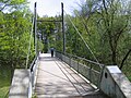
Numerous bridges and footbridges lead over the Argen and its source rivers . The largest bridge is the combined reinforced concrete and rope bridge with pylon near Neuravensburg , over which the Autobahn 96 leads. One of the oldest of its kind is the suspension bridge near the estuary. Numerous pedestrian bridges, especially in the lower area, are made using rope technology and are under historical protection.
Argensteg between Kressbronn and Langenargen
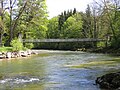
- From Lake Constance upriver is the new Argensteg, inaugurated on May 6th and 7th, 2000, about three hundred meters above the mouth . Two eight-meter-high pairs of pylons carry the 72-meter-long bridge. Its free span is 40 meters and the construction costs amounted to 600,000 Deutschmarks . The old Argensteg was destroyed by the floods in June 1999.
This is followed by the bridge of Landstrasse 334, the connecting road between federal roads 31 , 467 and Kressbronn with Langenargen.
Cable suspension bridge between Kressbronn and Langenargen
- The most important Argen Bridge for tourism is the very striking suspension bridge between Langenargen and Kressbronn, which was opened to traffic in 1898 as the second oldest suspension bridge in Germany. Since around 2010, the bridge has only been allowed to be used by pedestrians and cyclists.
Friedrichshafen – Lindau railway line
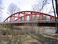
- About 100 meters above the suspension bridge, a 78-meter-long steel truss bridge built in 1898/99 by Maschinenfabrik Esslingen leads the single- track Friedrichshafen – Lindau railway over the Argen.
B 31
- In 1979 a new prestressed concrete bridge was built between Kressbronn and Langenargen, about 300 meters below the Kochermühle and Oberdorf, as part of the re-routing of federal highway 31 .
Bridge at the digester mill
- The makeshift repaired wooden bridge was replaced by an iron bridge by a resolution of October 4, 1876 - the cost was 45,642 marks. Due to the growing motor traffic, the Württemberg state decided in 1930 to build a new Argen bridge with a load capacity of 30 tons at its own expense. On October 4, 1934 this (building number 8323506) was opened to traffic. With a span of 54 meters, it served traffic for 45 years before it was relieved in 1979 by the bridge of the B 31.
B 467
- Another reinforced concrete bridge crosses the Argen between Kressbronn and Tettnang. The federal highway 467 coming from Ravensburg leads over it to Kressbronn. There is also the possibility for pedestrians to cross the Argen.
Giessen Bridge
- Until 1835, the bridge near Gießen at today's Gießenbrücke was the only way to cross the Argen between the southern villages of Langenargen and Gohren, Tunau , Reute or Schnaidt - now Kressbronn districts - on foot. Today's bridge was officially opened to traffic on August 5, 2000 (it had been possible to drive on since May 26) after a construction period of around 20 months (delayed by the two floods in February and May / June 1999). The construction costs amounted to 2.4 million D-Marks. The building number is 8323642.
Argensteg

Friedrichshafen – Lindau railway line
Kocher Bridge

Giessen Bridge

Footbridge at Badhütten
Footbridge at Heggelbach
Footbridge at Achberg Castle


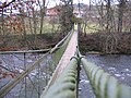
The next bridge offers traffic between the district road 7709 and Laimnau the opportunity to cross the Argen. This is followed by another suspension bridge between Badhütten and Unterlangnau, followed by a wooden walkway and the overpass of Landstrasse 331 between Oberlangnau and Steinenbach . The Jubiläumsweg Bodenseekreis crosses the Argen via the 39.10 meter wide hanging walkway near Heggelbach . Below Achberg Castle , the suspension bridge built in 1885 (span = 48.60 meters) connects the villages of Achberg with Flunau and Summerau . Upstream follow the Dametsweiler Steg and about 200 meters below the confluence of the Upper and Lower Argen the Pflegelberger Steg .
Others
- In September 2013, the Argen was named " River Landscape of the Years 2014/15 " by the Joint Water Council of Nature Friends of Germany (NFD) and the German Fishing Association (DAFV) . This will be proposed to the Federal Environment Minister for the list of official annual announcements of environmentally relevant actions and will be proclaimed on March 22, 2014, Water Day . The aim of the initiative is to sensitize the population to the natural and cultural beauties of selected rivers and at the same time to educate them about the threat to the respective rivers and their ecosystems.
- The riverside paths between Argensteg and Gießenbrücke are part of the Lake Constance marathon that starts in Kressbronn every September . The field of participants runs on the Kressbronn side towards Gießenbrücke and on the Langenargen side down towards Argensteg. From the Argen circular path, the runners have to go via Betznau to the finish at the Kressbronn festival hall.
- In Alemannia there was the Carolingian county Argungowe ( Argengau ) in the region from the end of the 8th century .
literature
- Norbert Kruse : The Argen and their names . In: In the Oberland . Volume 2, 2002, pp. 55-64 .
- Hermann Vogelmann: The bad ones. From the sources to the mouth . Eppe, Bergatreute 1988, ISBN 3-89089-009-1 .
- Andreas Schwab: When the Argen still flowed to the Danube ... In: In the Oberland. Issue 2, 2013, pp. 4–12.
- Wolfram Benz: Insights into the landscape history of the Western Allgäu . Immenstadt 2013, ISBN 978-3-931951-85-6 .
Web links
- Pictures around the argen
- Level of the Argen, below Gießenbrücke (list: Lake Constance and tributaries; level: Gießen, Argen)
- Vibration modes of the Achberger suspension bridge over the Argen
Individual evidence
- ↑ Measurement using a topographic map 1: 25,000
- ↑ a b WFD Documentation No. 10 on Argen
- ↑ a b c Geoportal Baden-Württemberg: LUBW service flowing waters - discharge parameters ( Memento from December 28, 2017 in the Internet Archive ) , as of December 1, 2016.
- ^ German Hydrological Yearbook Rhine Region, Part I 2009 State Institute for Environment, Measurements and Nature Conservation Baden-Württemberg, p. 72, accessed on January 22, 2016 (PDF, German, 1.85 MB).
- ↑ State Institute for the Environment Baden-Württemberg (LUBW) ( information )
- ↑ Information on the website of the Baden-Württemberg flood forecast center , accessed on August 27, 2015.
- ↑ lubw.baden-wuerttemberg.de
- ↑ The river landscape of the year is the Argen. In: Schwäbischer Zeitung. September 25, 2013. (tet07st4_25_Sep_SV)
