
Bayerisch Gmain
| coat of arms | Germany map | |
|---|---|---|

|
Coordinates: 47 ° 43 ' N , 12 ° 54' E |
|
| Basic data | ||
| State : | Bavaria | |
| Administrative region : | Upper Bavaria | |
| County : | Berchtesgadener Land | |
| Height : | 540 m above sea level NHN | |
| Area : | 12.34 km 2 | |
| Residents: | 3056 (Dec. 31, 2019) | |
| Population density : | 248 inhabitants per km 2 | |
| Postal code : | 83457 | |
| Area code : | 08651 | |
| License plate : | BGL, BGD, LF , REI | |
| Community key : | 09 1 72 115 | |
| LOCODE : | DE B2B | |
| Address of the municipal administration: |
Großgmainer Strasse 12 83457 Bayerisch Gmain |
|
| Website : | ||
| First Mayor : | Armin Wierer (FWG) | |
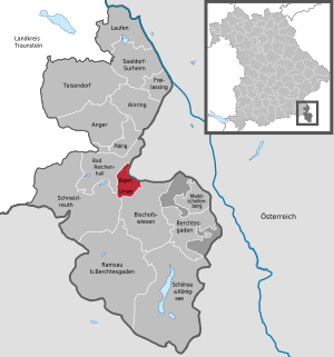
| Location of the municipality of Bayerisch Gmain in the Berchtesgadener Land district | ||
  |
||

Bayerisch Gmain is a municipality in the Upper Bavarian district of Berchtesgadener Land . It adjoins Bad Reichenhall . The Weißbach separates the community from the Austrian Großgmain .
Geographical location
The community is nestled between the Untersberg and Lattengebirge mountain ranges . In the north of the municipality is the Kirchholz (a training site with parts also in the city of Bad Reichenhall, until 1980 municipality-free ); The subsoil consists of Hasel Mountains , a mixture of salty clay and gypsum marl. In the district of Leopoldstal (incorporated in 1906 from the dissolved parish of St. Zeno ), plaster was previously extracted from it. The Weißbach represents a natural and political border to the Austrian Großgmain in the east .

View over the Gmain

View to Großgmain


history
"Auf der Gmain" is a name that has been used for centuries for the settlement area between Untersberg and Lattengebirge , Hallthurm and Kirchholz .
The people of the Bronze Age already knew the richness of the soil (salt in Reichenhall) and the favorable location of the area to appreciate and settled here firmly. In Roman times the area was called Mona , from which the name “Gmain” developed. The name of the place appears for the first time as part of a donation from the Bavarian Duke Theotpert (ruled approx. 711–716) to the Nonnberg Abbey in Salzburg in 712. Around 1100 appear the Counts of Plain , who made the area of the Gmain the center of the upper county in Salzburggau with the building of the Plainburg . Regardless of the sovereign border, which divided the widely scattered farms into a Bavarian and a Salzburg half after the decline of Plainian rule before 1300 (around 1295), the village community was always understood by the population as a unit.
The previously ducal Bavarian catchment area of the municipality is thus socio-culturally demarcated within the Berchtesgadener Land district from its southern Berchtesgadener Land region in the historical boundaries of the prince- provincial heartland and at the same time formed a link to the former archbishopric of Salzburg .
In the fulfillment of religious life, the canonical unit formed a community-building basis for all Gmainers. As far as the economic structure, cultural life in general and school education in particular are concerned, the state border along the Weißbach brook hardly played a role. The diverse family ties across the border naturally formed a strong link. The only thing separating was the Salzburg and Bavarian jurisdiction that ended at the Weißbach, which established the different sovereignty .
The state separation only gained real importance from 1816, when, after a short period of unification of the two districts under Bavarian administration, the political differences in the 19th century became more and more important. Despite the formation of two independent communities, the feeling of togetherness remained. The same economic interests, especially in tourism, contributed just as much as the usefulness of common technical facilities. The special attraction - and also an obligation - lies in the preservation of the common historical heritage with all the independence that has since developed.
On December 1, 1905, part of the dissolved municipality of Sankt Zeno was incorporated, namely the hamlet of Leopoldstal , a small exclave of Sankt Zeno east of Kirchholz am Weißbach .
On November 10, 1926, the municipality of Gmain was renamed to its current name.
In 1961 the community still had an area of 779 hectares. Its present size it reached in the context of administrative reform in Bavaria by the integration of the northern part of the former unincorporated area Forest St. Zeno (261,80 hectares) in the late 1970s that a rounding caused the municipal area, as well as another area of inclusion: On January 1, 1981, the municipality-free area in the north of Kirchholz was dissolved and almost two thirds of it (96.13 of 155.29 hectares) was incorporated into Bayerisch Gmain. Only Forst St. Zeno is a separate, second district within the municipality. The other incorporated areas (Leopoldstal, Kirchholz) belong to the Bayerisch Gmain district (972.55 hectares).
When the unincorporated area of Bischofswiesener Forst in the south was dissolved on January 1, 2010 , part of this area was added to the community and district of Bayerisch Gmain.
Population development
Between 1988 and 2018 the municipality grew from 2,563 to 3,100 by 537 inhabitants or 21%.
religion
The Catholic parish church is consecrated to St. Niklaus von Flüe .
The place belongs to the catchment area of the Evangelical Lutheran parish in Bad Reichenhall with its Evangelical town church .
politics
Municipal council
The municipal council election on March 15, 2020 resulted in the following distribution of seats:
- CSU: 5
- Free community of voters: 4
- GREEN: 3
- FDP: 3
- SPD: 1
- Total: 16
mayor
Armin Wierer (FWG) has been the mayor since March 5, 2019. The predecessor was Hans Hawlitschek (CSU) since May 1996.
badges and flags
Blazon : Divided; above roughened with silver and blue, below in red two horizontal silver fish one above the other.
The diamonds refer on the one hand to the former Wittelsbach sovereigns as well as to today's Bavaria . The lower part, on the other hand, refers to the so-called Gmain or Großgmain , which was subordinate to the Prince Archbishopric of Salzburg .
The official place name "Bayerisch Gmain", which has been valid since 1926, refers to a special territorial-historical situation which, when the coat of arms was adopted in 1963, led to a special permit that the community may use the diamonds in the community coat of arms. The lower red field with the two silver fish is taken from the coat of arms of the Augustinian provost of St. Zeno in Reichenhall, which was of great importance as a manor in the municipality.
Coat of arms since 1963 on the legal basis of a resolution of the municipal council and the award of the coat of arms by the State Ministry of the Interior after a ministerial resolution of September 16, 1963.
A white and blue flag with the municipality 's coat of arms is used as the unofficial municipal flag .
Architectural monuments
Economy and Infrastructure
The tourism is an important source of income for the community, a recognized holiday and spa resort is. The tourist offers within are advertised in close connection with the neighboring town of Bad Reichenhall in the association Bayerisches Staatsbad - Kur-GmbH Bad Reichenhall / Bayerisch Gmain , which in turn is a co-partner of the marketing company Berchtesgadener Land Tourismus , which promotes the entire district . In addition to its central location within the district, the municipality itself offers the Alpgarten toboggan run for winter sports .
In the village of Bayerisch Gmain there is the Bavarian Fire Brigade Recreation Home , now called the St. Florian Guesthouse & Restaurant.
traffic
The highest-ranking road connection in the municipality is the B 20 from Berchtesgaden and on to Bad Reichenhall.
Bayerisch Gmain has a train station on the Freilassing – Berchtesgaden line . Since 2006 it has been served hourly in both directions by the S4 ( Berchtesgadener Land Bahn ) line of the Salzburg S-Bahn . With the IC Königssee - which is, however, designated as a local train in this section of the route - from and to Hamburg there is also an intercity stop in the municipality.
Personalities
- Max Bernuth (1872–1960), painter, book illustrator.
- Dieter Dressler (1932–2011), painter and graphic artist.
- Hans Erlwein (1872–1914), architect, town planner in Bamberg and Dresden
- Leodegar Mayr (1928–2013), violin maker
- Ines Papert (* 1974), sport climber and ice climbing world champion
- Claire Waldoff (1884–1957), cabaret artist, singer, lived in Bayrisch Gmain from 1939 until her death
literature
- Johannes Lang , Max Schneider: On the Gmain - Chronicle of the communities Bayerisch Gmain and Großgmain. Self-published by the municipalities of Bayerisch Gmain and Großgmain 1995.
Web links
- Website of the municipality of Bayerisch-Gmain
- Entry on the coat of arms of Bayerisch Gmain in the database of the House of Bavarian History
Individual evidence
- ↑ "Data 2" sheet, Statistical Report A1200C 202041 Population of the municipalities, districts and administrative districts 1st quarter 2020 (population based on the 2011 census) ( help ).
- ↑ a b c Municipal Council - Bayerisch Gmain Municipal Council (overview) , without information on voter participation, online at bayerisch.gmain.de
- ↑ See Johannes Lang, Max Schneider: Auf der Gmain. Chronicle of the communities Bayerisch Gmain and Großgmain , pp. 31–32; Johannes Lang: History of Bad Reichenhall , Philipp Schmidt Verlag 2009, pp. 190–191, 859 ISBN 978-3-87707-759-7
- ↑ The cultural landscapes of Bavaria: Diversity - Home - Protected Property ( Memento from March 27, 2019 in the Internet Archive ), PDF file, online at www.heimat-bayern.de
- ↑ a b Wilhelm Volkert (Ed.): Handbook of the Bavarian offices, communities and courts 1799–1980 . CH Beck, Munich 1983, ISBN 3-406-09669-7 , p. 434 .
- ↑ Mayor , online at bayerisch.gmain.de , accessed on May 14, 2020
- ↑ a b c d Entry on the coat of arms of Bayerisch Gmain in the database of the House of Bavarian History
- ↑ Entry on Bayerisch Gmain on the Kommunalflaggen.eu page
- ↑ Bayerisch Gmain: The sun terrace of the Alpine city , online at bad-reichenhall.de
- ↑ Alpgarten toboggan run - sledding under floodlights , online at bad-reichenhall.de
- ↑ Archive link ( Memento of the original from January 26, 2013 in the Internet Archive ) Info: The archive link has been inserted automatically and has not yet been checked. Please check the original and archive link according to the instructions and then remove this notice.

Ainring | Anger | Bad Reichenhall | Bayerisch Gmain | Berchtesgaden | Bischofswiesen | Freilassing | Running | Marktschellenberg | Piding | Ramsau near Berchtesgaden | Saaldorf-Surheim | Schneizlreuth | Schönau am Koenigssee | Teisendorf
Unparished areas:
Eck |
Schellenberger Forest