Belsenplatz (Düsseldorf)
| Belsenplatz | |
|---|---|
| Place in Düsseldorf | |

|
|
| Basic data | |
| place | Dusseldorf |
| District | Oberkassel |
| Created | 1898 in today's form |
| Confluent streets | Luegallee, Hansaallee, Lanker Strasse, Quirinstrasse, Belsenstrasse, Greifweg, Sonderburgstrasse |
| Buildings | old trainstation |
| use | |
| User groups | Pedestrian traffic , bicycle traffic , car traffic , public transport |
| Space design | Tram stops, bus stops |
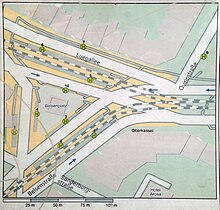
The Belsenplatz is the transportation hub in Düsseldorf district of Oberkassel , which at the western end of the highway Luegallee north of the gripper path and south, Hansaallee in District 4 is. At this neuralgic point with its 150 meters long and 100 meters wide, in the shape of a triangle, there are eight stops for trains and buses at a distance of up to 140 meters. Other radial streets of Belsenplatz are the associated Belsenstraße and Sonderburgstraße.
history
The Belsenplatz was a place where previously there was presumably a protection of trees, since the name of the place according to the address book of 1905 was derived from "Belse", more precisely from "In den Belsen", which in the Lower Rhine region means in the middle of Was called poplar or aspen trees. In Roman times, a large military road ran along the Rhine along the Lower Germanic Limes from Colonia (Cologne) to Batavodurum (Nijmegen). This road ran west of Heerdt, spared the peninsula and secured the Rhine as a border against the Teutons. The legionary camp Novaesium was located on this trade and military route in what is now Neuss-Gnadental , only about 10 kilometers from Belsenplatz. In the middle of the 14th century, the parish of Heerdt covered the entire curve of the Rhine, and in addition to the village of Heerdt, there were the modest rural settlements of Oberkassel, Niederkassel, Ober- and Niederlörick and the Rheinaue. A forest belt, the Heerdter Busch , closed off the peninsula to the west . The district belonged to the abbess of the noble women's monastery St. Quirin , who received the essential income from the parish and appointed the pastor of Heerdter, who then became the sole authority in the parish.
The expansion of Düsseldorf to the left bank of the Rhine did not begin until the 17th century. With the signing of the Vienna Congress Act on June 9, 1815 and the beginning of the allocation of the Rhineland to Prussia , the rural community of Heerdt was added to the Neuss district. In 1839, the first semi-permanent connection between Düsseldorf and Oberkassel was built with a pontoon bridge .
After the construction of the Oberkassel Bridge in 1898 which was Rheinstation the Rhine meadows, the local existing since 1854 Station of the Royal Directorate of the Aachen-Dusseldorf-Ruhrorter Railway , with which was founded in 1846 in Düsseldorf Aachen Neuss railway company which Oberkassel with Neuss union, the relocated to today's Belsenplatz. From there, the “State Railway of Neuss” (see map section 1905) ran from Düsseldorf-Oberkassel along the Greifweg in the direction of Neuss . With the construction of the Oberkassel Bridge, the technical prerequisites for the rail-bound crossing of the Rhine were created. On December 15, 1898, the Rheinische Bahngesellschaft AG , or Rheinbahn for short, founded in 1896 , put the electrical rail link into operation, which led from Düsseldorf via Belsenplatz to Moers and Krefeld. In 1901 the light rail line to Neuss was added as a branch from Belsenplatz .
From 1902, the old Oberkasseler Bahnhof , which was built in 1898 and is now a listed building, was only used for freight traffic . As early as 1901, the station is said to have been turned into an inn, which was run as a popular meeting place by the Vossen family from 1911 until the end of the 1980s. The Rheinische Bahngesellschaft built a new, strong dike and crossed Oberkassel with a network of roads. The development of land along the new railway line was intended to finance the construction of the railway. From 1906 to 1914 there was brisk construction activity. On average, a hundred new houses were built every year and the population rose from 4,400 in 1895 to 11,400 in 1907. Due to the expansion of the built-up urban space, industrialization in surrounding villages and the development of the same by railroad and roads, the incorporation of the Heerdt mayor's office after Düsseldorf needed and the station forecourt was renamed "Belsenplatz". The "Bahn Strasse" that ran from there was also given its new name "Belsenstrasse", because there was already a Bahnstrasse in the center of Düsseldorf . The station of the state railway , from 1924 of the Deutsche Reichsbahn-Gesellschaft at Belsenplatz had become an enormously important hub. All trams and long-distance trains coming from Düsseldorf went to Belsenplatz. There they parted in the directions Neuss, Krefeld, Moers.
Belsenplatz still separates the old and the other Oberkassel from one another. Behind the middle-class Oberkassel, the industrial Oberkassel began with the site of the former Oberkassel freight station, which had ceased rail operations in 1981. In 1899, the Rheinbahn had contractually secured the monopoly on supplying Heerdt and Oberkassel with gas and electricity. The railway area could be used excellently for this. Along the Hansaallee , named after the association of German merchants, a power station (power station) for the Rheinische Bahngesellschaft was built next to a tram depot. Even with a brick factory, the company secured a monopoly on the manufacture of building materials for a time. In 1971, after relocating in the 1920s, the Rheinbahn moved its headquarters back to Oberkassel. In 2017, the property on Hansaallee was sold for around 50 million euros and the headquarters moved to Lierenfeld .
In the post-war years of the Second World War , the Alte Oberkasseler Bahnhof was used again as a passenger station for a short time. In 1992 the listed station was revived as a landmark and the “Belsenbräu”, since 2011 the “Gulasch Alt”, was brewed in front of the guests.
Adjacent buildings

At Belsenplatz No. 2 is the old station Oberkassel , with colored facing made of red and yellow bricks, which is now used as a brewery for Altbier with gastronomy. In contrast, between 1898 and 1900, the perimeter blocks were built in the neo-renaissance style. The building at Belsenplatz No. 1 was carried out by the construction company “Weyland and Hoover”. The “Hülsmann” brasserie has been located here since 2009 . House no. 3 was built by the architect Fritz Hofmeister (1869–1941), who also built the Tietz department store on Schadowstrasse . This building also maintains two types of restaurants and a magazine / tobacco shop with a post office on the ground floor . In the middle of the square, on the traffic island, there is a Rheinbahn pavilion with access to public toilets under No. 5 . Behind the old train station, Belsenplatz no. 2a, is the "Château Rikx" in a former car repair shop for changing tires. The Rikx is at the same time a pub, café, district bar and club with demolished charm.
- Monuments and buildings in the vicinity of the square - see the list of architectural monuments in Oberkassel
traffic
The Belsenplatz is the left-bank traffic junction of the rail - lines U70, U74, U76 U77 and U75 , and the bus lines 828, 862 , 833, 834, 835, 836 and 805 (night traffic).
Today's meaning
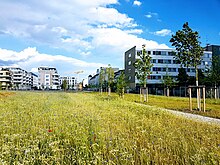
The “Belsenpark”, a park with the surrounding residential area (a so-called green axis), which is located on the site of the former Oberkassel freight station, connects via a pedestrian zone and “ Theo-Champion- Strasse”. The construction of the green area of the "Belsenpark", a 20,400 square meter park on the " Ria-Thiele- Strasse", along the "Greifweg" began in March 2016. The park is intended to serve as a local recreation area for the population.
Although the volume of traffic has increased due to additional construction work behind Belsenplatz, the infrastructure has not changed, the square is as ugly as ever and the design of Belsenplatz threatens to become a never-ending story. For years now, the district council on the left bank of the Rhine has been asking for an adapted traffic concept, especially for Belsenplatz, with every new property in the district's catchment area. The city planners put off the politicians from year to year. In 2014, for example, it was said that the voting process was still in progress. The city's specialist administration is of the opinion that the square cannot be designed because of its many traffic connections, proposals from the Transport and Improvement Association (VVV) on the left bank of the Rhine are not feasible and too expensive. In 2006, the group of architects from the VVV on the left bank of the Rhine presented a draft for the reconstruction and design of the square, the core and prerequisite of which is the merging of the three train stops into one elevated platform.
literature
- Hans-Joachim Neisser: 100 years of Düsseldorf on the left bank of the Rhine, or how Düsseldorf came across the Rhine . Grupello Verlag, 2009, ISBN 978-3-89978-099-4
Web links
- History workshop Düsseldorf: Belsenplatz and Belsenstraße , from geschichtswerkstatt-duesseldorf.de, accessed on August 12, 2017.
- Photo from the Düsseldorf City Archives: “Belsenplatz Transport Hub”, around 1910 , on express.de, accessed on August 12, 2017.
Individual evidence
- ↑ Maps Düsseldorf: Belsenplatz
- ^ Jörg Janssen: The new headquarters of the Rheinbahn. In two weeks the Rheinbahn is leaving its old company headquarters in Oberkassel. Yesterday she presented her new domicile in Lierenfeld. , Rheinische Post, dated April 8, 2017
- ↑ Virtual tour of the Brauhaus Alter Bahnhof , at brauhaus-alterbahnhof.de
- ↑ Because everyone has to! Pictures of the kiosk and toilet, Belsenplatz , on klofuehrer.com, accessed on August 12, 2017
- ↑ According to the Düsseldorf address book from 1905 , the name comes from the field name "Grippert". Could be derived from Agrippina . A large military road ran along the Rhine from the Lower Germanic center Colonia Claudia Ara Agrippinensium (Cologne) to Batavodurum (Nijmegen) and secured the Rhine as a border against the Teutons. This road ran west of Heerdt and spared the peninsula. Also close to the former Novaesium legionary camp in Neuss-Gnadental.
- ↑ Helga Meister: A traffic concept is in sight for Belsenplatz , Westdeutsche Zeitung , December 13, 2015
- ↑ What is happening at Belsenplatz. The VVV presents its plans! October 12, 2006 ( Memento of the original from August 20, 2017 in the Internet Archive ) Info: The archive link was inserted automatically and has not yet been checked. Please check the original and archive link according to the instructions and then remove this notice. , at vvv-linksrheinisch.de, accessed on August 13, 2017
Coordinates: 51 ° 13 ′ 53.3 " N , 6 ° 44 ′ 50.4" E


