
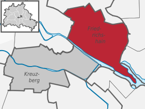
Berlin-Friedrichshain
|
Friedrichshain district of Berlin |
|
|---|---|
  |
|
| Coordinates | 52 ° 30 '57 " N , 13 ° 27' 15" E |
| height | 33- 78 m above sea level. NN |
| surface | 9.78 km² |
| Residents | 136,035 (Dec. 31, 2019) |
| Population density | 13,910 inhabitants / km² |
| Start-up | Oct. 1, 1920 |
| Postcodes | 10243, 10245, 10247, 10249, 10178, 10179, 10317 |
| District number | 0201 |
| structure | |
| Administrative district | Friedrichshain-Kreuzberg |
| Locations | |

Friedrichshain is a district in the Friedrichshain-Kreuzberg district of Berlin . Until the merger with the then neighboring Kreuzberg district during the administrative reform in 2001 , there was an independent Friedrichshain district , which is congruent with today's Friedrichshain district. The district takes its name from Volkspark Friedrichshain in the north and extends south to the banks of the Spree . The area around Simon-Dach-Strasse and Revaler Strasse is a trendy district with a lively nightlife and cultural life that is known beyond the city limits.
Location and development structure

Friedrichshain is bounded - starting in a clockwise direction west - as follows: Lichtenberger Straße , Mollstraße , Otto-Braun-Straße , Am Friedrichshain , Virchowstraße , Margarete-Sommer-Straße , Danziger Straße , Landsberger Allee , Hausburgstraße , Thaerstraße , Eldenaer Straße , S-Bahn Trasse , Kynaststrasse , Stralau Peninsula , Spree .
The district is a typical former workers' district and was considered a classic tenement area. However, today only the eastern area of the district is characterized by this building structure from the Wilhelminian era , in the far west, prefabricated structures dominate. In between there are areas in which architecture from the early days of the GDR dominates. In the south, former port, railway and industrial areas take up large parts of the district. A part of the railway facilities is used ( Ostbahnhof , Bahnhof Warschauer Straße , Ostkreuz ) and is part of the East-West railway line through the inner city of Berlin ( Stadtbahn ), which is important for traffic .
The Wilhelminian-style quarters in the east of the district are considered to be trendy and bar districts, especially the area south of Frankfurter Allee and east of Warschauer Strasse. The center of this bar area is Simon-Dach-Straße .
In the western part of the district, buildings from different phases of the post-war period dominate . The border to the Wilhelminian style development in the eastern part is roughly marked by Comeniusplatz and Kadiner Straße. To the west of it, Wilhelminian-style buildings are only available on islands. Grosse Frankfurter Strasse and Frankfurter Allee in the characteristic style of Stalinist neo-classicism , which were expanded in the 1950s to form the boulevard Stalinallee, form a dominant main thoroughfare . Buildings in this style also extend north and south of it. The area around Hildegard-Jadamowitz-Straße plays a special role . The Friedrichshain cell , which was built immediately after the Second World War and is reminiscent of classic modernist settlements from the 1920s, is located here. To the west of the Weberwiese underground station , there are still some buildings from the first post-war development in the tiled stove design , which were restored after 1990 and are now all listed. Otherwise, prefabricated buildings and urban development that are reminiscent of large housing estates predominate in the west of the district: relaxed and green construction with high-rise slabs, high-rise lines and point high-rise buildings .
Special areas in the district are the Volkspark Friedrichshain in the north, the banks of the Spree in the south, the area around the Mercedes-Benz Arena , the extensive railway areas or former railway areas in the south of the district and the Stralau peninsula in the southeast, where a rather high-priced A residential area near the water (Spree and Rummelsburger Bucht) with a suburban, partly sophisticated character was created. The railway areas, some of which are no longer used, include parts of the tram route, today's Ostbahnhof (formerly: Schlesischer Bahnhof), the former Ostgüterbahnhof (formerly: Schlesischer Güterbahnhof), the Postbahnhof, the old railway station of the Royal Eastern Railway, the former Wriezener Bahnhof and other freight yard areas former Reichsbahn repair shop (RAW site) and the route from Ost- and Schlesischer Bahn to Ostkreuz. The properties on the Friedrichshain Ufer der Spree belong to the Media-Spree project area , most of which was a border area during the GDR era .
In the 2000s, neighborhood structures were created through planning spaces: the district administration subdivided the area along Petersburger / Warschauer Straße into the forecast area Friedrichshain-West (04) and the forecast area Friedrichshain-Ost (05) . The further subdivision takes place in the district region and planning area, provided with numbers according to EDP:
- 04 Friedrichshain-West
- 0405 Karl-Marx-Allee North
- 040501 Barnimkiez, north of Mollstrasse / Landsberger Allee including the Volkspark Friedrichshain
- 040502 Friedenstrasse, south of Mollstrasse / Landsberger Allee and west of Auerstrasse
- 040503 Richard-Sorge-Strasse, between Auerstrasse and Petersburger Strasse
- 0407 Karl-Marx-Allee Süd
- 040701 Andreasviertel, west of Andreasstrasse
- 040702 Weberwiese, east of Andreasstrasse
- 040703 Wriezener Bahnhof, south area between Andreas- and Rüdersdorfer Straße
- 0405 Karl-Marx-Allee North
- 05 Friedrichshain-East
- 0506 Frankfurter Allee North
- 050601 Hausburgviertel, north of Bersarinplatz and Thaerstraße
- 050602 Samariterviertel, south of Bersarinplatz and Thaerstraße
- 0508 Frankfurter Allee Süd
- 050801 Traveplatz, to Boxhagener Straße
- 050802 Boxhagener Platz, between Boxhagener Straße and the railway site
- 050802 Stralauer Kiez, south of the railway area
- 050802 Stralauer peninsula, east of the railway area
- 0506 Frankfurter Allee North
history
overview
Friedrichshain divided historically in the territories east Stralauer suburbs , Boxhagen , Stralau , Samaritan district and the eastern royal city , to the former to Lichtenberg belonging colony Friedrichsberg . Before 1920, the city limits ran across the district. At least according to their name, the Frankfurter Tor and the Oberbaumbrücke as names of old customs stations bear witness to this . The Frankfurter Tor as a former city gate (see also: Berlin customs and excise wall ) was, however, at the level of the Weberwiese subway station and not at today's Frankfurter Tor intersection at Warschauer Strasse / Karl-Marx-Allee . It was only with the reorganization of the city of Berlin in the 1920s that today's district emerged as a district. It is divided into six areas , which are divided by the major streets of the district, plus Stralau and Stralauer Kiez in the south on the Spree .
Prehistory of the district

The oldest part of today's district of Friedrichshain is the medieval fishing village Stralau , located on the Stralau peninsula, which also gave the Stralau suburb its name.
Boxhagen and Friedrichsberg are also historical locations in the district. Boxhagen has been the name of a farm since the 16th century , and later also of a small settlement of colonists. Boxhagen was already in use as a field name before the 16th century. Friedrichsberg is also a colony (colonist settlement) that was established here in 1770.
By far the largest part of today's Friedrichshain district goes back to the former suburbs of Berlin, on the one hand to parts of the royal city, on the other hand to the majority of the Stralau suburb. This makes up the largest part of today's district.
The prehistory of Friedrichshain is therefore above all the history of the Stralauer Vorstadt (also: Stralauer Viertel). This area was a suburb of old Berlin , which emerged in the 17th century east of the old city limits (the city limits were then the course of today's S-Bahn line between Alexanderplatz and west of the Jannowitzbrücke ) towards the village of Stralau. The Stralau suburb gradually expanded further and further east.
Until the 19th century, horticulture was the main activity in the rather rural Stralau district.
With the construction of the Frankfurt train station in 1842, the district changed, tenements and factories were built. Textile industry (weaving, bleaching and dyeing mills), wood processing and a paper mill, food industry (breweries, dairies, meat factories, sugar factories, vinegar factories, mills) as well as iron foundries and machine factories (e.g. Julius Pintsch AG ) are examples of the beginning industrialization of the district.
The first waterworks in Berlin went into operation in 1856 at Stralauer Tor (e.g. on the site of the later incandescent lamp works ). Berlin's first municipal gas plant was built at Stralauer Platz from 1845 to 1847 .
With the railway station of the Royal Eastern Railway , the Wriezen railway station and freight yard areas, large-scale additional railway areas were gradually added until the First World War.

Until 1920, the Stralau suburb grew more and more to the east and then bordered directly on Boxhagen and Friedrichsberg (both of which are now part of Lichtenberg). The Samariterviertel and the slaughterhouse area (which today does not belong to Friedrichshain) also belonged to the Stralauer Vorstadt, as did the Rudolfkiez, but Stralau did not.
Development of the district since the formation of Greater Berlin
In 1920, what was then the Friedrichshain district was formed. It comprised most of the Stralau suburb, a small part of the royal city and Stralau. Boxhagen and Friedrichsberg were not yet included in 1920 and were initially assigned to the Lichtenberg district. By far the largest share of the district area created in 1920 was the former Stralauer Vorstadt. The name Friedrichshain was new as a city area name and is derived from the Volkspark on the edge of the former district, which owes its name to King Friedrich II .
Friedrichshain was a stronghold of the Social Democrats and Communists in the 1920s and 1930s and at the same time a main stage of the struggles that the workers' parties waged among themselves and against the National Socialists in Berlin. After the seizure of power by the Nazis in 1933, an extensive and diverse developed in the district of resistance against Nazism . On September 28, 1933, the new rulers named Friedrichshain after one of their idols, the Friedrichshain SA leader Horst Wessel , who was killed by communists in 1930 , as Horst-Wessel-Stadt (from 1936 to 1945: Horst-Wessel ).
With the Berlin territorial reform on April 1, 1938, the district area changed considerably when it incorporated the parts of the Lichtenberg district west of the Ringbahn , which make up most of the historic Friedrichsberg and Boxhagen area . The population of the district, which in October 1937 was around 289,000, rose to over 353,000 in October 1938.
During the Second World War , the Allied air raids and the urban warfare in the Battle of Berlin destroyed large parts of Friedrichshain.
After the war until the fall of the Berlin Wall
In June 1945 the Berlin magistrate ordered that the district be renamed "Friedrichshain".

Friedrichshain was in the Soviet sector and therefore in East Berlin since the Berlin administration was divided . The transition to the West Berlin district of Kreuzberg was the Oberbaumbrücke. The interior wall on Mühlenstrasse , which has been preserved on the banks of the Spree, is now a tourist attraction as the East Side Gallery .
In the course of the reconstruction after the Second World War, the Stalinallee was created . In the further course of the GDR era, prefabricated building areas were built in the west of the district.
.svg)
Since 1990
.svg)
The political change in 1989/1990 also marked a deep and momentous turning point in Friedrichshain .


During the fall of the Wall and afterwards, many squatters from the left-wing scene - especially from West Berlin - used the vacancies in the unrenovated old building areas in the eastern part of the district to squat . In 1990 this wave of squatters ended with street battles on Mainzer Straße . Many of the houses were cleared by the police (see: Clearance of Mainzer Straße ). Some of the former occupiers still live in “their” houses today. The squatter culture often gave rise to important and popular socio-cultural institutions in Friedrichshain: bars, event rooms, advice centers, video cinemas. This probably also contributed to the fact that Friedrichshain attracts more and more students and tourists who discover the “trendy district” for themselves.

At the end of the 1990s, the area around Simon-Dach-Straße developed into a pub district with many small shops that tend to attract young people from all over the city and tourists. In particular, the many pubs with their numerous seats on the wide sidewalks have not only met with approval from some residents: Recently, Friedrichshain - especially Simon-Dach-Straße - has often been part of the public discussion about noise pollution and the so-called " Ballermann " -Tourism "advised. Especially in the summer months, dispute between residents and restaurateurs regularly breaks out.
Today most of the old buildings have been refurbished and the district is in the progressive gentrification process because the increasing attractiveness of the restaurants, shops and studios makes the district interesting for investors and new residents. The district is characterized by an alternative student milieu and a stronghold of left-wing parties . The Greens and the Pirates achieved their highest election results here next to the neighboring Kreuzberg.
Individual areas of the district
Osthafen and incandescent lamp factory in Rudolfkiez
Before the Second World War and during the existence of the GDR, Friedrichshain was a working-class district with many industrial and commercial enterprises. The Osthafen , located in the south of Friedrichshain, was one of the most important transhipment points in East Berlin at that time, at the same time it was a border area to West Berlin and could only be used to a limited extent after the Wall was built in 1961. The warehouses and cold stores on the bank still bear witness to this time. The Osthafen underground station (until 1924: Stralauer T [h] or ), located directly on the Oberbaumbrücke, was not rebuilt after its destruction in World War II. After the political change , the inland shipping company had some port buildings extensively renovated and found new users. The egg cold store directly on the Oberbaumbrücke serves Universal Music as its headquarters, and the music broadcaster MTV has moved into its quarters next to it .
In the industrial area to the north of the port, Deutsche Gasglühlicht AG had built a large plant for the production of light bulbs , which became Osram Plant D (wire plant) in 1919/20 . The World War II severely damaged factory in Rudolf neighborhood was in GDR times, the Berlin Glühlampenwerk and 1969 in the Kombinat incandescent works NARVA integrated. At times, up to 5000 people were employed in the NARVA incandescent lamp factory . After it was closed, not only the jobs disappeared, but also the term “NARVA” from Berlin and Friedrichshain almost completely. Only the SG NARVA Berlin sports club and the “NARVA Lounge” club are reminiscent of the old name.
After German reunification , the entire area was sold to an investor who, however, was not interested in further industrial production. The building complex, now called Oberbaum City , was refurbished at a cost of more than one billion euros and subsequently mainly rented to service providers. A total of around 70 companies with around 2200 employees had settled in the area by the 2010s. Berlin's oldest skyscraper (Narva / Osram Tower) , which was built in 1909, belongs to the industrial area . After the renovation, the tower was extended by a five-storey glass tower. Since the tower was fitted with light installations, it rises like a mushroom over the surrounding buildings.
Industrial area on the Ringbahn

In the east of Friedrichshain there is another former industrial area on today's Neue Bahnhofstrasse . In 1904, Georg Knorr had a large office and factory complex built ( Knorr-Bremse AG ) in an area on the Berlin Ringbahn that belonged to the municipality of Boxhagen-Rummelsburg . The Knorr-Bremse AG was in 1954 VEB Berliner Bremsenwerk converted. Today one of the buildings houses a Knorr-Bremse AG museum. The buildings are under monument protection. The part of the site on the other side of the Ringbahn belongs to the Rummelsburg district in the Lichtenberg district . A larger complex of the facility is used by the Deutsche Rentenversicherung .
Volkspark Friedrichshain and hospital in Friedrichshain

From 1846 to 1848 the Volkspark Friedrichshain was laid out in the east at the gates of the city of Berlin , which was later to give the district its name. It was the first people 's park in Berlin.
In 1874, on the advice of Rudolf Virchow, the first city hospital in Berlin, the Friedrichshain hospital , was opened after six years of construction. It was built directly on Landsberger Allee in Volkspark Friedrichshain, which was expanded to include the so-called "New Grove" to the east. Among other things, the hospital was home to the GDR's first kidney transplant center . Today the clinic in Friedrichshain belongs to Vivantes GmbH and is a hospital with a focus on accidents.
Karl-Marx-Allee
At the end of the Second World War there was intense fighting between the Wehrmacht and the Red Army in the Battle of Berlin on Frankfurter Allee , which was almost completely destroyed as a result.
In the 1950s, as part of a programmatic reconstruction project by the Socialist Unity Party of Germany (SED), apartment blocks were built here in the “ confectioner's style ” based on the Soviet model. Since 1949 the street was called Stalinallee and received the first Stalin monument in the GDR. On June 17, 1953, construction workers started the June 17 uprising here . As a result of the de-Stalinization in the Soviet Union, the SED had the Stalin memorial removed on the night of November 14, 1961 and the Stalinallee renamed Karl-Marx- and Frankfurter Allee. The Kosmos cinema was opened near the Frankfurter Tor in 1962 - at that time the largest and most modern cinema in the GDR. In 1996 it was expanded to become the first multiplex cinema in Berlin and at the end of 2005 it was converted into an event center.
The buildings on Karl-Marx-Allee are now a listed building and were extensively renovated in the 2000s.

Karl-Marx-Allee, corner of the street of the Paris Commune
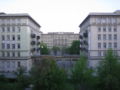
Frankfurter Allee 5 and 7, view from Liebigstrasse
.JPG)


traffic
Private transport
The two federal highways B 1 and B 5 run through Friedrichshain in a common route (Karl-Marx-Allee, Frankfurter Allee) and B 96a ( Petersburger Straße , Warschauer Straße , Stralauer Allee ). Four bridges over the Spree connect Friedrichshain with the Berlin districts south of the river: Michaelbrücke , Schillingbrücke , Oberbaumbrücke and Elsenbrücke . The reconstruction of the Brommy Bridge , which was destroyed in World War II, is planned.
Rail transport
One of Berlin's major long-distance train stations is located in Friedrichshain - the Ostbahnhof . When the new Berlin Central Station went into operation in 2006, the Ostbahnhof lost its importance, as most of Deutsche Bahn's long-distance trains in the north-south direction now pass through the new Central Station, which was designed as a crossing station.
The Ostbahnhof had different names in the course of time: Frankfurter Bahnhof, Lower Silesian-Märkischer Bahnhof, Schlesischer Bahnhof, Ostbahnhof, Hauptbahnhof and today again Ostbahnhof . To the northeast was Wriezener Bahnhof , the beginning and end of the Berlin – Wriezen railway line and originally just a side platform of today's Ostbahnhof . With the construction of the Stadtbahn in 1882, which was partly built on the old city moat, today's Ostbahnhof was on a continuous railway line, while the Wriezener Bahnhof quickly lost its importance as a terminus and suburban station. It no longer exists today. In its place, an industrial park with a metro wholesale market and a Hellweg construction market was opened in September 2006 .
Transportation


Train
Ostkreuz station, which is largely located in Friedrichshain, is Germany's busiest station with 1,500 train stops every day. This is where the Stadtbahn and the Ringbahn cross . It has been extensively rebuilt since 2007 and has also been connected to the regional rail network since 2015 . After several delays, full operation began in December 2018. The Ringbahnhalle of the S-Bahn was finished in April 2012. The square in front of the train station is to be redesigned and a new reception building built.
Subway
In the years 1895–1899 a tunnel was built between Stralau and Treptow , which was supposed to prove that underground trains can also be built under rivers like the Spree . The tramway operation through the tunnel was set 1932 1948, the tunnel was due wartime filled damage. Since the 1980s, only the tunnel road and a small green area have been reminiscent of the Spree tunnel .

A high web viadukt leads from cross Berg on the Oberbaumbruecke to Friedrichshain for terminus Warschauerstrasse the subway line U1 . It is a transfer station for the S-Bahn with lines S3, S5, S7, S75 and S9. The underground station is an imposing industrial building with an extensive track system and two large storage halls. The entire system was extensively restored at the beginning of the 1990s.
The long-term Berlin subway planning provided for the U1 line not to end at the Warschauer Brücke , but rather to extend it to the Frankfurter Tor subway station of the U5 . In the meantime, however, this project has been abandoned in favor of the renovation of other, already existing underground lines. Before the Second World War, the Stralauer Tor elevated station (from 1924: Osthafen ) was located on the northern bank of the Spree between the Warschauer Straße underground station (until 1995: Warschauer Brücke ) and the Schlesisches Tor underground station , which was destroyed during the war and not rebuilt .
Friedrichshain was connected to the eastern outskirts and Alexanderplatz in 1930 via today's U5 line . An extension to the government district and the new Berlin Central Station is to take place by 2020.
tram
Friedrichshain was served by several tram lines from the 1870s. Until the turn of the century, these mostly ran as horse-drawn trams . The oldest routes in the area of today's district were the ring line of the Great Berlin Horse Railway via Friedenstrasse - Strausberger Strasse - Andreasstrasse - Schillingbrücke in the years 1876–1879 and the route from Alexanderplatz through today's Karl-Marx-Allee and Frankfurter Allee Friedrichsberg in 1878. 1881-1883 followed the route through Landsberger Allee and Petersburger Strasse to the Zentralvieh- and Schlachthof on Forckenbeckplatz , in 1885 the tram through Holzmarktstrasse in the direction of Schlesischer Bahnhof and in 1890 the tram through Grüner Weg (today: Singerstrasse) to Küstriner Platz (today: Franz-Mehring-Platz ). At the turn of the century, these lines were electrified and new lines opened by other operators. From 1899 the Berlin Ostbahnen ran from the Schlesisches Bahnhof through the Spreetunnel mentioned above to Treptow and the trains of the Continentalen Society for electrical companies ran through Landsberger Allee to Hohenschönhausen . In 1901 the elevated railway company , which also operated the first Berlin subway, opened the flat railway from the Warschauer Brücke to the Zentralviehhof, and in 1908 the city of Berlin opened its first own tram line . From 1907 there was also a tram route from Frankfurter Allee to Boxhagen-Rummelsburg . By 1928, all of the businesses were combined in the BVG . After 1945, the routes through Frankfurter Allee, the former Grüner Weg and along Friedenstrasse were no longer in operation. The connection through Andreasstraße was closed until 1966, the one along Holzmarktstraße and Stralauer Allee followed until 1969.
The routes along Landsberger Allee / Platz der United Nations / Mollstrasse (lines M5, M6 and M8), Petersburger / Warschauer Strasse (M10, partly M13 and line 21), Scharnweber- / Weichsel- / Holtei are still in operation - / Wühlisch- / Kopernikusstraße (line M13, partly line 16) and Eldenaer Straße / Weidenweg and Boxhagener Straße (line 21).
District Mayor
The following list ends with the year 2000, because as a result of the administrative reform in 2001 Friedrichshain was combined with Kreuzberg to form a new large district.
| Period | Surname | Political party |
|---|---|---|
| 1921-1933 | Paul Mielitz | SPD |
| 1933-1938 | Max Conrad | NSDAP |
| 1938-1944 | Günther Hüber | NSDAP |
| 1944-1945 | Hans Fink | NSDAP |
| 1945-1946 | Paul Lippke | SPD |
| 1946-1947 | Fritz Saar | SPD, then SED |
| 1947 | Wilhelm Mardus | SPD |
| 1948 | Heinz Griesch | SPD |
| 1948 | Erwin Butte | SED |
| 1948-1950 | Willi Schmidt | SDA |
| 1950-1953 | Gustav-Adolf Werner | SED |
| 1953-1956 | Fritz Reuter | SED |
| 1956-1975 | Hans Höding | SED |
| 1975-1989 | Manfred Pagel | SED |
| 1989-1990 | Heinz Borbach | SED |
| 1990 | Hans-Günter Baudisch | SED |
| 1990-2000 | Helios Mendiburu | SPD |
Sights (selection)
|
Sacred building |
|
See also
- List of cultural monuments in Berlin-Friedrichshain
- List of stumbling blocks in Berlin-Friedrichshain
- Rose Theater
- Spreeturm
Schools (selection)
- Modersohn Primary School , Niemannstrasse
- Ellen-Key-Schule , integrated secondary school with upper secondary school , Rüdersdorfer Straße
- Andreas-Gymnasium , Koppenstrasse
- Georg-Friedrich-Händel-Gymnasium , Frankfurter Allee
- Heinrich-Hertz-Gymnasium , Rigaer Strasse
- Friedrichshain Music School , Zellestrasse
- Berlin School for Drama , Boxhagener Strasse
literature
- Hanno Hochmuth: Neighborhood history. Friedrichshain and Kreuzberg in divided Berlin. Wallstein 2017, ISBN 978-3-8353-3092-4 .
- Ralf Schmiedecke: Berlin-Friedrichshain (= The series archive images ). Sutton, Erfurt 2006, ISBN 3-86680-038-X .
- John Stave : living room and kitchen. Experienced and exquisite. 5th edition. Eulenspiegel-Verlag, Berlin 2001, ISBN 3-359-00478-7 .
- Jan Feustel: Walks in Friedrichshain (= Berlin reminiscences. No. 64). Haude & Spener, Berlin 1994, ISBN 3-7759-0357-7 .
Web links
- Official website of the Friedrichshain-Kreuzberg district of Berlin
- Picture gallery of Friedrichshain places / places
Individual evidence
- ↑ Friedrichshain residential cell at www.stadtentwicklung.de; accessed on April 2, 2018.
- ↑ Hans-Rainer Sandvoss : Resistance Friedrichshain and Lichtenberg (= German Resistance Memorial Center (ed.): Series “Resistance in Berlin 1933–1945” ), self-published German Resistance Memorial Center, Berlin 1998, passim.
- ↑ https://www.tagesspiegel.de/berlin/brauner-friedrichshain/8853912.html
- ^ Administrative structure of the city of Berlin: Alt-Berlin with Stralau . In: Berliner Adreßbuch , 1934, IV., S. XIX.
- ↑ Administrative districts 1–6 . In: Berliner Adreßbuch , 1936, IV., P. 992.
- ↑ Population of the imperial capital Berlin . In: Berliner Adreßbuch , 1939, before Part 1, p. 18.
- ^ Hans Joachim Reichhardt (arrangement): Berlin. Struggle for freedom and self-government 1945-1946 (= series of publications on contemporary history in Berlin , volume 1). 2nd Edition. Spitzing, Berlin 1961, p. 131.
- ↑ Final spurt at Ostkreuz . In: Punkt 3 , DB AG, June 22, 2017.
- ^ Heinz Jung: The tram ring lines in Berlin . In: Berliner Verkehrsblätter . Issue 1, 1961, pp. 3-4 .
- ↑ a b Hans-Joachim Pohl: The New Berlin Horse Railway Society. The traffic development of Weißensee and Lichtenberg (part 1) . In: Verkehrsgeschichtliche Blätter . Issue 1, 1986, pp. 2-11 .
- ↑ Jens Dudczak, Uwe Dudczak: Great Berlin tram. In: beefland. Retrieved March 26, 2013 .
- ^ Wilfried Seydel: The tram tunnel between Stralau and Treptow . In: Verkehrsgeschichtliche Blätter . Issue 1, 1981, pp. 9-15 .
- ↑ Michael Günther: With interest guarantee for the manor castle. How the tram came to “Hohen = Schönhausen” . In: Verkehrsgeschichtliche Blätter . Volume 5, 1999, pp. 118-131 .
- ^ Hans-Joachim Pohl: The urban trams in Berlin. History of a municipal transport company . In: Verkehrsgeschichtliche Blätter . Volume 5, 1983, pp. 86-106 .
- ↑ Sigurd Hilkenbach, Wolfgang Kramer: The trams of the Berlin Transport Authority (BVG East / BVB) 1949-1991 . transpress, Stuttgart 1999, ISBN 3-613-71063-3 , pp. 15/16 .
- ↑ Sigurd Hilkenbach, Wolfgang Kramer: The trams of the Berlin Transport Authority (BVG East / BVB) 1949-1991 . transpress, Stuttgart 1999, ISBN 3-613-71063-3 , pp. 18/19 .


Middle (1) | Tiergarten (2) | Wedding (3) | Prenzlauer Berg (4) | Friedrichshain (5) | Kreuzberg (6) | Charlottenburg (7) | Spandau (8) | Wilmersdorf (9) | Zehlendorf (10) | Schöneberg (11) | Steglitz (12) | Tempelhof (13) | Neukölln (14) | Treptow (15) | Köpenick (16) | Lichtenberg (17) | Weissensee (18) | Pankow (19) | Reinickendorf (20) | Marzahn (21) | Hohenschönhausen (22) | Hellersdorf (23)