
Bluestone
| coat of arms | Germany map | |
|---|---|---|

|
Coordinates: 48 ° 26 ' N , 9 ° 53' E |
|
| Basic data | ||
| State : | Baden-Württemberg | |
| Administrative region : | Tübingen | |
| County : | Alb-Danube district | |
| Height : | 609 m above sea level NHN | |
| Area : | 55.6 km 2 | |
| Residents: | 16,161 (Dec. 31, 2018) | |
| Population density : | 291 inhabitants per km 2 | |
| Postal code : | 89134 | |
| Primaries : | 07304, 0731 | |
| License plate : | UL | |
| Community key : | 08 4 25 141 | |
| LOCODE : | DE BLS | |
City administration address : |
Marktplatz 2 89134 Blaustein |
|
| Website : | ||
| Mayor : | Thomas Kayser | |
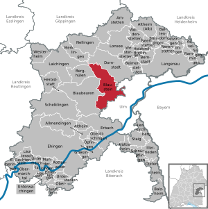
| Location of the town of Blaustein in the Alb-Danube district | ||
  |
||

Blaustein is a town in the Alb-Donau district in Baden-Württemberg . With 16,161 inhabitants, it is the second largest city in the district (as of the end of 2018).
geography
Geographical location
Embedded between Hochstrasse , Blautal , Lautertal and the plateau of the Swabian Alb , Blaustein is located immediately west of Ulm . The city lies at an altitude between 490 and 690 meters. The rivers Blau and Lauter - which has its source in Lautern (Blaustein) - flow through the urban area.
Community structure and neighboring communities
The town of Blaustein consists of the ten districts Arnegg , Bermaringen , Dietingen , Ehrenstein , Herrlingen , Klingenstein , Lautern , Markbronn , Weidach and Wippingen . Blaustein borders in the northeast on Dornstadt , in the southeast on the city of Ulm , in the west on the city of Blaubeuren and in the northwest on Berghülen .
history
Bluestone
Bluestone was already settled in the Neolithic. There was a Neolithic village near Ehrenstein , which was included as a UNESCO World Heritage Site in 2011 . The community and later town of Blaustein was not created until September 1, 1968 through the union of the communities Ehrenstein and Klingenstein. The name was redeveloped at that time. In the course of the community reform during this time, Markbronn-Dietingen was first incorporated into Arnegg on July 1, 1971. On October 1, 1974, Bermaringen and Wippingen were incorporated into Blaustein. The municipality of Blaustein received its current form on January 1, 1975 through the union of the municipalities of Arnegg, Blaustein and Herrlingen.
Before 1810, the ten districts were a good example of the dismemberment into a wide variety of dominions and landscapes. Districts of Blaustein were z. B. to the monastery of Söflingen (Ehrenstein), to the knighthood of Bernhausen (Klingenstein and Herrlingen), to the German order commander Ulm (Arnegg), to the free imperial city of Ulm (Bermaringen), to the Duchy of Württemberg (parts of Wippingen) and to the monastery of Elchingen (small part of Wippingen ). Some of the villages were Catholic, some were Protestant, and Wippingen was mixed. Each district can look back on centuries of history. As a result, the districts preserved their independence and identity. Since 1975 the districts have gradually grown together.
All sub-towns were originally characterized by agriculture. Since the construction of the Ulm – Sigmaringen railway line by the Württemberg State Railroad in 1868, several industrial companies have settled in the Blautal. Blaustein benefited from the proximity and the good connection to Ulm. So the character of the villages in the Blautal changed; especially in the three districts of Ehrenstein, Klingenstein and Herrlingen. After the establishment of the Kingdom of Württemberg , the localities, which were distributed across the Blaubeuren and Ulm authorities, all came to the Ulm district during the district reform during the Nazi era in Württemberg in 1938 . Therefore, the communities became part of the American zone of occupation in 1945 and thus belonged to the newly founded state of Württemberg-Baden , which was incorporated into the current state of Baden-Württemberg in 1952. During the district reform in Baden-Württemberg in 1973, Blaustein came to the newly founded Alb-Donau district. After Blaustein had taken on more and more urban character, Blaustein was elevated to a city on October 1, 2014.
Districts
Arnegg


The place, which was first mentioned in a document in 1292, is grouped around the Arnegg ruin of the same name , of which only remnants are preserved today. After changing local lords, the further development of the Altshausen Teutonic Order has been determined since 1700 .
You can still see the Zehntscheuer built under the Teutonic Order in the 17th century, the Marienkirche built in 1737 and the administrative building built in 1783, which is still used today as the town hall (local administration). In 1806 Arnegg fell to the Kingdom of Württemberg and was subordinate to the Blaubeuren district office. In 1938 Arnegg came to the district of Ulm and in 1973 to the Alb-Donau district. In 1975 Arnegg was incorporated into the municipality of Blaustein.
Bermaringen
The Alemanni settled in the area around 1750 years ago. They found an ideal area at an altitude of approx. 650 meters above sea level. Fertile arable soils, protective forests and spring water from the nearby Lauter. It is very likely that the Alemanni had to fight for their chosen place against the Romans. The victorious hundred around the chief “Bermar” (which means “the strong bear”) settled down. The new settlement Bermaringen was named after him. The village was first mentioned in a document in 1225.
After various noble families such as the Counts of Dillingen and the Counts of Helfenstein were in the possession of Bermaringen in the Middle Ages, the Stein zu Klingenstein families and the lords of Lauterstein and von Hörningen appeared as joint local lords in the 14th century. The local rule was sold to the Ehinger family in Ulm in 1444, later to the Kraft family, then in 1484 to the Urspring Monastery and finally in 1512 to the imperial city of Ulm. In 1803 the place fell to Bavaria and in 1810 to Württemberg, which made it subordinate to the Oberamt Blaubeuren. In 1938 Bermaringen came to the district of Ulm. On October 1, 1974, Bermaringen was incorporated into Blaustein.
Ehrenstein

From the Löwenfelsen (Schlossberg) there are finds of an early Bronze Age hill settlement, on the basis of which Hans Jürgen Hundt first defined the ceramics of the transition period BzA2 / B1.
Ulm archivists point to a not insignificant use of the Löwenfelsen (Schlossberg) in Roman times. These report in the middle of the 18th century that a life-size statue of a Roman god or emperor made of bronze was found in the valley north of the Ehrensteiner Löwenfelsen (Schlossberg). A rescue expedition sent from Ulm could unfortunately only find out that the Ehrenstein farmers had meanwhile thoroughly destroyed the ancient statue as an idol with the participation of the local pastor and had sold the remains to passing scrap metal dealers.
Erichstain Castle, first mentioned in 1137 and expanded around 1220 on today's Löwenfelsen (Schlossberg), was demolished in 1281, except for the castle chapel, first mentioned in 1275, due to a dispute with the city of Ulm. From then on, the chapel served as the parish chapel of the town of Ehrenstein, which belongs to the castle. In 1724 this last remnant of Ehrenstein Castle was demolished in favor of the much larger baroque new church St. Martin im T (h) al. In place of the castle chapel, a wayside shrine that has been preserved to this day was built. The church Skt. Martin im T (h) al, formerly located northwest of the Blau on Hummelstraße, has now completely disappeared from the townscape. In the course of the redesign of the center of Blaustein and due to structural damage, it was demolished together with the neighboring old town hall and school building in 1983 and replaced by modern office and residential buildings. The important late Gothic depictions of saints kept in it (including a late Gothic Ulm Madonna) were transferred to the new St. Martin Church on the newly created Blausteiner Marktplatz.
Since the end of the 1950s , the residential area Pfaffenhau has been growing in the east of Ehrenstein directly on the city limits to Ulm and from Ulm on three sides. In 1994 the remains of a small hill settlement from the Urnfield period were found there.
Historically, Söflingen Monastery has ruled Ehrenstein since 1539. In 1803 the place came to the Electorate of Bavaria and in 1810 to Württemberg. The place was subordinated to the Oberamt Ulm and in 1938 came to the district of Ulm. In 1968 it merged with Klingenstein to form the municipality of Blaustein.
Herrlingen

The district of Herrlingen goes back to the construction of Horningen Castle (later: Oberherrlingen Castle) in the 11th or 12th century. It has 2,799 inhabitants and was incorporated into the municipality in 1975.
Klingenstein


The Klingenstein district is largely shaped by Klingenstein Castle and the ruins of Klingenstein Castle surrounding it . The castle, which was probably built at the beginning of the 12th century on a rocky promontory dominating the middle Blautal valley, was first mentioned in 1215 and was closely related to the Palatinate in Ulm. As the largest castle complex in the Blautal valley, it formed the core of the rule of the von Stain / Klingenstein family, which branched out into different lines . Their extensive possessions extended in the 14th century over several suburbs of what is now the greater community of Blaustein. Klingenstein Castle later came into the possession of the von Werdenberg family and finally the von Bernhausen family. In 1588 the castle was given up as a residence in favor of the newly built Oberherrlingen Castle and left to decay. The castle was finally destroyed in 1630 during the Thirty Years' War . In 1756 the Lords of Bernhausen erected a small baroque palace in the ruins of the castle.
In 1806 Klingenstein fell to the Kingdom of Bavaria and, in accordance with the border treaty between Bavaria and Württemberg in 1810, to the Kingdom of Württemberg . Klingenstein was subordinated to the Blaubeuren Oberamt. In 1860, the castle and ruins became the property of the Leube family of pharmacists and inventors from Ulm. Today they are owned by the Leube Foundation.
In 1938 Klingenstein came to the district of Ulm. In 1968 the merger with Ehrenstein took place to form the new municipality of Blaustein.
The center of Klingenstein is characterized by the Hotel Klingenstein (reopened in 2018) . The restaurant had previously been known under the historical name of Kalte Herberge for centuries .
Other buildings of cultural and historical interest in Klingenstein are the quarry settlement on Arnegger Strasse, which was built around 1900 , the Catholic St. Joseph im Tal church, built and equipped in the expressionist style from 1932 to 1933 , as well as the remains of a formerly closed development in the late (sober) Art Nouveau style along Ulmer Strasse , on the lower Galgenbergstrasse and in the Molitorstrasse. The little-noticed Evangelical Kreuzkirche, completed in 1931 by the Stuttgart architects Klatte and Weigle, is one of the few expressionist church buildings in Baden , along with the neighboring church of St. Joseph im Tal, the Martin Luther Church in Ulm and the Evangelical Church in Gerhausen ( Blaubeuren ). Württemberg .
Markbronn-Dietingen
Weidach
Weidach lies between the Lautertal and the Kiesental. Weidach was first mentioned in a document in 1225 as Widach . Weidach has belonged to Württemberg since 1810.
The district has two Catholic churches. St. Wendelin has a small bell tower, the church of St. Nikolaus von Flue has no bell tower. Weidach shares a mayor with Herrlingen. In Weidach there is a civic association in addition to the rural women’s association, the singing association and the volunteer fire brigade.
Wippingen
.png)
Wippingen has been known in a document since 1085; In 1611 it burned down almost completely. The Zollhaus, an old, now restored half-timbered building, still exists today. It played a not inconsiderable role in the dispute between the imperial city of Ulm and the Duchy of Württemberg ( see also Burgrest Lauterstein ). Since 1810 Wippingen belonged to the Kingdom of Württemberg and was subordinate to the Oberamt Blaubeuren. In 1938 Wippingen came to the Ulm district.
Population development
Population figures according to the respective area. The figures are census results (¹) or official updates from the respective statistical offices ( main residences only ).

|
|
¹ census result
politics
Municipal council
The local election on May 26, 2019 in Blaustein led to the following official final result. The municipal council consists of the elected voluntary councilors and the mayor as chairman. The mayor is entitled to vote in the municipal council.
- CDU 28.0% (−5%), 6 seats (−1)
- Free voters 22.3% (-3.3%), 5 seats (-1)
- Greens 27.3% (+ 4.8%), 6 seats (+1)
- SPD 13.8% (−5%), 3 seats (−1)
- BBB (Citizens' Alliance Blaustein) 8.6%, 2 seats (+2)
mayor
The first mayor of the entire community of Blaustein was Robert Epple. His successors in office were Gerhard Häberle (1992–2000) and Gerald Schikorr (2000–2008). Thomas Kayser has been mayor since February 1, 2008. He had won the election in November 2007 with 64.6% of the vote against the incumbent G. Schikorr. In November 2015, Kayser was confirmed in office with 67.7% of the votes.
coat of arms
The Blaustein coat of arms has represented the community of Blaustein since May 30, 1978. The previous coats of arms of the former sub-communities or districts lost their legal significance due to the formation of the community Blaustein (in the course of the community reform ).
Blazon of the coat of arms: "Split of gold and black, in front three black wolf rods (set in stakes) , behind an upright golden horn with a golden fetter."
Since the gentlemen from Stein zu Klingenstein (the Wolfsangeln ) and the gentlemen from Herrlingen-Hörningen (the Hifthorn ) owned local rulership or property over all of the suburbs, their symbols should best represent all the districts from a historical perspective today.
flag
The municipality flag was also awarded on May 30, 1978 and corresponds to the colors of the coat of arms with the colors yellow (gold) -black. The flag is only used on special occasions, e.g. B. in municipal elections.
Local councils
In addition to the local council, the ten districts form various local councils. The districts of Ehrenstein and Klingenstein together form a committee. The local councils offer citizens in the individual districts direct contact persons for various issues and requests.
The following associations exist to form a local council:
- Arnegg, Dietingen and Markbronn (Mayor Manfred Strobel)
- Bermaringen (Mayor Hilde Mayer)
- Wippingen and Lautern (Mayor Peter Enderle)
- Herrlingen and Weidach (Mayor Rita Sommer)
Community partnerships

The municipality of Blaustein has had a municipal partnership with the municipality of Moustoir-Remungol in France since 1993 .
Culture and sights
theatre
There has been a small theater in Blaustein since 1985, the Herrlinger Theater since 2018 under the direction of the director Edith Ehrhardt; previously under the direction of principal Wolfgang Schuhkraft. From 2010 to 2018 the "Summer Theater" also existed in a tent with 200 seats between the "Epple Stadium" and "Bad Blau".
Museums and exhibitions
In the foyer of the Blaustein town hall there is a small exhibition of archaeological finds and a model of the Neolithic Ehrenstein settlement. The exhibition can be visited during the normal opening hours of the town hall.
The Villa Lindenhof in Herrlingen with the Museum Lebenslinien, which was redesigned in 2019, can only be viewed by appointment . It shows very different personalities from Herrlingen, e.g. B. Erwin Rommel , Anna Essinger and Hugo Rosenthal . Erwin Rommel is also commemorated by his grave in the Herrlingen cemetery and the Rommel memorial stone erected on the site of his forced suicide between Herrlingen and Wippingen.

A memorial plaque in front of the Erwin-Rommel-Steige 50 building commemorates the rural school home, founded by Anna Essinger with a reform pedagogical orientation and, after her emigration in 1933, continued as a Jewish rural school home by Hugo Rosenthal until 1939 . At least 15 teachers and students were victims of the Nazi terror . In the annex house under the rainbow , a permanent exhibition provides information about the work of this school.
Buildings


- Catholic Marienkirche in Arnegg
- Catholic Trinity Church in Arnegg, built in 1961
- Evangelical Church of Our Lady in Lautern with a late Gothic carved altar from the Ulm school
- Catholic Martinskirche in Dietingen
- Catholic Martinskirche in Ehrenstein
- Maria Hilf chapel in Herrlingen
- Catholic Andreas Church in Herrlingen
- Evangelical St. Mark's Church in Markbronn
- Catholic Church St. Nikolaus vd Flüe in Weidach
- Catholic Wendelinus Chapel in Weidach
- Catholic Brother Konrad Chapel in Wippingen
- Blaustein community center , planned and built by the master architects from Ulm .
Regular events
- Every year at the end of September the "Blausteiner Herbst" takes place, a big city festival with music, a craft market, food and drink stalls, Sunday shopping etc. The "Blausteiner Herbst" is organized by the "VSB Association of Self-Employed in Blaustein".
- Shortly before Christmas, the one-day Blausteiner Christmas market takes place on the market square in front of the town hall. The Christmas market is supported by various associations and groups that donate the entire proceeds for social and cultural purposes to the community.
- On Ascension Day, the Musikverein Blaustein e. V. squat in the market square at the town hall . Starting with a white sausage breakfast or a morning pint, the market square lasts until the evening and is very popular. The music association accompanies the event with traditional music.
- In the last week of June, the Musikverein Blaustein e. V. the traditional two-day forest festival at Lehmansblick.
Economy and Infrastructure
traffic
Blaustein has two train stations (Blaustein and Herrlingen) on the Ulm – Sigmaringen railway line . Regional trains stop every hour . Several DING bus lines cross the town and connect with Ulm and other places in the area. Blaustein is located directly on federal highway 28 and close to the A 8 and A 7 motorways .
A variant of the Danube cycle path leads through Blaustein. The Alb-Neckar cycle path reaches Blaustein as a long-distance cycle path . It leads from Ulm to Heilbronn .
energy


In the wind farm near Blaustein, electricity is generated with eleven wind turbines . See also: List of wind turbines in Baden-Württemberg .
education
The community has six primary schools in the districts of Arnegg, Bermaringen, Ehrenstein, Herrlingen, Klingenstein (all-day school) and Wippingen, a secondary school (in Ehrenstein) and a special needs school (in Klingenstein).
Personalities
sons and daughters of the town
- Karl Heinrich Rüdiger (1877–1947), born in Bermaringen, lawyer, 1920–1933 District Administrator of Böblingen
- Johannes Häußler (1879–1949), born in Arnegg, mayor of Neckarsulm
- Karl Häußler (* 1930), Mayor of Nersingen , member of the Bavarian State Parliament
- Wolf-Dieter Hepach (1939–2018), historian
- Wolfgang Fahrian (* 1941), soccer player and goalkeeper of the German national soccer team at the 1962 World Cup
- Otto Schaude (1944–2016), born in the district of Wippingen, educator and clergyman, bishop of the Evangelical Lutheran Church of the Urals, Siberia and the Far East
- Peter Brannath (* 1960), author
- Thomas Kurfeß (* 1962), multiple world champion and gold medalist at the Paralympics
- Rolf Baumann (* 1963), soccer player and coach
- Dieter Baumann (* 1965), former athlete and Olympic champion
- Lucca Staiger (* 1988), national basketball player
Other personalities

- Marquard Anton von Bernhausen, lord in Eppishausen, Klingenstein and Herrlingen, canon in the prince-bishops of Eichstätt and Augsburg, † 1699 in Eichstätt
- Anna Essinger (1879–1960) managed her Jewish school home in Herrlingen until around 1938. This home was described by a contemporary witness as a paradise in hell. The house of the country school home is at Erwin-Rommel-Steige 1.
- Erwin Rommel (1891–1944), during the Second World War among other things Commander in Chief of the German Africa Corps and Army Group B , which was responsible for the defense of the " West Wall " , lived with his family in the Herrlingen district (then Wippinger Steige, today: Erwin- Rommel-Steige; the house originally belonged to the complex of the Jewish country school home). After a serious wound, he was picked up at home by two high-ranking officers on October 14, 1944 while on convalescence leave and forced to commit suicide by taking potassium cyanide while driving between Herrlingen and Wippingen. The former “favorite general of the Führer” had fallen out of favor with Hitler because he had given critical presentations on the situation on the Western Front. He was also suspected of being involved in the July 20, 1944 assassination attempt on Hitler . There is a memorial stone at the place where Rommel died. Rommel is buried in the Herrlinger Friedhof. A Rommel Museum was set up in the Herrlinger Lindenhofvilla some time ago, replacing a rather temporary memorial in two rooms of the Herrlinger Town Hall.
- Jörg Sieber (* 1961), singer of the rock band Dominoe , composer for film and commercial film music , sound engineer, spent his childhood and youth in Bermaringen.
literature
- Hartwig Zürn: The Neolithic village of Ehrenstein (Ulm district) . Excavation 1960. Part I: The building history . Publ. State Office for monument protection Stuttgart A 10/1, Stuttgart 1965
- J. Lüning, Ulrike Sommer, K. A. Achilles, H. Krumm, J. Waiblinger, J. Hahn, E. Wagner: The Neolithic Village Ehrenstein III Part III: The Finds. Research u. Ber. Before u. Prehistor . Bad-Württ. 58, Stuttgart 1997
- H.-J. Hundt: Pottery from the end of the early Bronze Age from Heubach (Kr. Schwäbisch Gmünd) and Ehrenstein (Kr. Ulm) . Fundber. Schwaben N.F. 14, 1957, 27-50
- Johann Daniel Georg von Memminger : Description of the Oberamt Ehingen . Cotta-Verlag, Stuttgart and Tübingen 1826.
Web links
- Internet presence of the city of Blaustein
- Internet presence of the Bermaringen district
- Internet presence of the Markbronn-Dietingen district
Individual evidence
- ↑ State Statistical Office Baden-Württemberg - Population by nationality and gender on December 31, 2018 (CSV file) ( help on this ).
- ^ Federal Statistical Office (ed.): Historical municipality directory for the Federal Republic of Germany. Name, border and key number changes in municipalities, counties and administrative districts from May 27, 1970 to December 31, 1982 . W. Kohlhammer, Stuttgart / Mainz 1983, ISBN 3-17-003263-1 , p. 543 .
- ↑ Blaustein is promoted to town on October 1st . ( Memento of the original from September 24, 2015 in the Internet Archive ) Info: The archive link was inserted automatically and has not yet been checked. Please check the original and archive link according to the instructions and then remove this notice. Southwest Press
- ^ Weidach [living space]. In: leo-bw.de. Retrieved January 29, 2017 .
- ↑ Baden-Württemberg State Statistical Office
- ↑ State Statistical Office Baden-Württemberg 2014 ( page no longer available , search in web archives ) Info: The link was automatically marked as defective. Please check the link according to the instructions and then remove this notice.
- ↑ swp.de
- ↑ a b Common Official Journal Baden-Württemberg : GABI 328/1979
- ↑ Memorial sites for the victims of National Socialism. A documentation, Volume I, Bonn 1995, pp. 26f., ISBN 3-89331-208-0
- ^ Project citizen center Blaustein in the district Pfaffenhau. Retrieved September 16, 2019 .

Allmendingen | Altheim | Altheim (Alb) | Amstetten | Asselfingen | Ballendorf | Balzheim | Beimerstetten | Berghulen | Bernstadt | Blue beers | Bluestone | Börslingen | Breitingen | Dietenheim | Dornstadt | Ehingen (Danube) | Emeringen | Emerkingen | Erbach | Griesingen | Grundsheim | Hausen am Bussen | Heraldstatt | Holzkirch | Hüttisheim | Illerkirchberg | Illerrieden | Laichingen | Langenau | Lauterach | Lonsee | Merklingen | Munderkingen | Neenstetten | Nellingen | Nerenstetten | Oberdischingen | Obermarchtal | Upper Stadium | Öllingen | Öpfingen | Rammingen | Rechtenstein | Rottenacker | Schelblades | Lace-ups | Setzingen | Staig | Untermarchtal | Lower Stadium | Unterwachingen | Weidenstetten | Westerheim | Westerstetten