
Bramberg am Wildkogel
|
Bramberg am Wildkogel
|
||
|---|---|---|
| coat of arms | Austria map | |
 |
|
|
| Basic data | ||
| Country: | Austria | |
| State : | Salzburg | |
| Political District : | Zell am See | |
| License plate : | ZE | |
| Surface: | 117.27 km² | |
| Coordinates : | 47 ° 16 ' N , 12 ° 21' E | |
| Height : | 819 m above sea level A. | |
| Residents : | 3,935 (January 1, 2020) | |
| Postcodes : | 5733, 5741 | |
| Area code : | 06566 | |
| Community code : | 5 06 01 | |
| NUTS region | AT322 | |
| Address of the municipal administration: |
Dorfstrasse 100 5733 Bramberg am Wildkogel |
|
| Website: | ||
| politics | ||
| Mayor : | Hannes Enzinger ( ÖVP ) | |
|
Municipal Council : (2019) (21 members) |
||
| Location of Bramberg am Wildkogel in the Zell am See district | ||
  |
||
 Bramberg and the Salzach Valley (1965) |
||
| Source: Municipal data from Statistics Austria | ||

Bramberg is an Austrian municipality in the Zell am See (Pinzgau) district in the Salzburg region with 3935 inhabitants (as of January 1, 2020). It is located in the Oberpinzgau region , about 10.5 kilometers from its capital Mittersill and 38 kilometers from the district capital Zell am See , and is one of the communities in the Hohe Tauern National Park .
origin of the name
According to Lahnsteiner, the place name developed from “Prentenperige” (1160) via “Brennenberch” (1244) and “Praemberch” (1314) to Bramberg and is due to the fact that the sunny side, the Sonnberg, suffers particularly from sunburn.
geography
The center of Bramberg is at an altitude of 819 meters at the southern foot of the Wildkogel , 2224 m high , on the left - northern, sunny - bank of the Salzach . The most important tributaries of the Salzach are from the north, coming from the Kitzbühel Alps , the Mühlbach , from the south, originating in the Hohe Tauern, the Schönbach , the Habach , the Steinbach and the Wennsbach .
Community structure
The municipal area comprised 14 localities by 2020: Bicheln, Bramberg am Wildkogel including Bramberg and Weichseldorf, village including Dorf-Passthurn and Kronau, Habach including wastelands, Habachtal and Steinach, Hohenbramberg, Leiten including Erlach, Mühlbach , Mühlberg, Schönbach including house, Schweingg, Sonnberg, Steinach, Wenns and Weyer including the Weyerhof. As of 2020, the community will only consist of one village.
The community consists of four cadastral communities (area as of December 31, 2019):
- Bramberg (1,080.96 ha)
- Habach (5,746.19 ha)
- Mühlbach (1,143.65 ha)
- Mühlberg (3,748.72 ha)
The municipality of Bramberg has a registry office and maintains the citizenship record for the entire municipality.
Bramberg was part of the Mittersill judicial district until 2002 and has been part of the Zell am See judicial district since 2003 . Together with eight other Oberpinzgau communities, Bramberg forms the Oberpinzgau regional association.
The municipality is, together with the other Oberpinzgau municipalities between Krimml and Hollersbach , part of the Oberpinzgau West cleanliness association, which is responsible for the infrastructure regarding sewerage and the proper disposal of waste water from the region.
In elections to the Austrian National Council (Austria), the five electoral districts of the municipality of Bramberg am Wildkogel belong to the regional constituency of Lungau / Pinzgau / Pongau (5c) and the regional constituency of Salzburg . In the Salzburg state elections for the Zell am See electoral district (6).
Neighboring communities
| Kirchberg in Tirol and Jochberg ( Kitzbühel District , Tyrol ) |
Mittersill ∗ |
|
| Neukirchen am Großvenediger |
.svg)
|
Hollersbach in Pinzgau |
| Matrei in Osttirol ( Lienz district , Tyrol ) |
- ∗ Short border in the mountains, the place Mittersill is exactly east behind Hollersbach
history
The Leitengut belonging to the community was mentioned in a document in 925. Bramberg is the oldest parish in the upper Salzach Valley and was first mentioned in 1160 as Prentenperige .
In ancient times the area around Bramberg was a copper ore mining center. Ore mining was resumed in 1829 and finally abandoned in 1863. Attempts to resume mining in the 20th century failed.
Famous was the emerald mining in Habachtal , next to Norway and Italy the only Emerald -Fundort in Europe.
As the pastor of his home parish Dorfgastein , Andreas Rieser criticized the Hitler regime and its protagonists early on, and was therefore imprisoned and tortured in concentration camps , but ultimately survived and later worked as a village pastor in Bramberg. His history was documented and in 2013 the church square was renamed "Rieser-Platz" in his memory and as a warning.
Since prices of around 600 euros per square meter of building land are already being paid in the village, the municipal council has decided to require applicants to give 40% of the area to the municipality in order to be able to build inexpensively for the locals.
Population development

Culture and sights
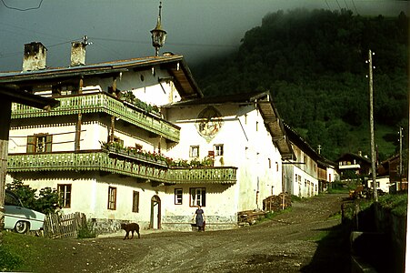
Site, 1965

Gasthof Kaserer, 1965


- Parish church Bramberg am Wildkogel
- Chapel of the dead northwest of the parish church
- Vicarage, built in 1799
- Local history museum, former Wilhelmgut
- Weyer ruins
- Gasthof Senningerbräu, former Zehenthof with a medieval core
- Hans Panzl memorial
Economy and Infrastructure
traffic

For car traffic, the east-west connection is opened up by federal highway 165. As part of the Salzburg transport network, both the narrow-gauge Pinzgauer Lokalbahn , which connects to the Austrian main railway network in Zell am See , and the postbuses in the direction of Krimml and Zell am See operate in the context of the Salzburg transport network .
education
- The community of Bramberg operates a community kindergarten and has a primary and secondary school.
- Tourismusschule (TS) Bramberg of the Tourismusschulen Salzburg
sport and freetime
- Football club TSU Bramberg
- Wildkogel ski area on the Wildkogel
- Cable car to the Wildkogel, called the Smaragdbahn, since December 2010
- illuminated toboggan run, 14 km long
- illuminated cross-country and skating trails
- Swimming pool with a large children's playground
- Flying school for paragliding and hang gliding
politics
The community council has a total of 21 members.
- After the municipal council and mayoral elections in 2004, the municipal council had the following distribution:
- 11 SPÖ
- 9 ÖVP
- 1 BBL - Bramberger Citizens List
- After the municipal council and mayoral elections in 2009 , the municipal council had the following distribution:
- 10 ÖVP
- 9 SPÖ
- 2 BBL
- After the municipal council and mayoral elections in 2014 , the municipal council had the following distribution:
- 11 ÖVP
- 7 SPÖ
- 3 BBL
- After the municipal council and mayoral elections in 2019 , the municipal council has the following distribution:
- 10 ÖVP
- 6 SPÖ
- 5 BBL
- mayor
- 1936–1945 Matthias Blaikner
- 1945-1945 Jakob Scheuerer
- 1945–1954 Ferdinand Nindl (ÖVP)
- 1954–1972 Matthias Blaikner (ÖVP)
- 1972–2003 Karl Nindl (ÖVP)
- 2003–2004 Günter Steiner (ÖVP)
- 2004–2014 Walter Freiberger (SPÖ)
- since 2014 Hannes Enzinger (ÖVP)
coat of arms
The coat of arms of the municipality shows according to the coat of arms description :
“Two towering silver battlements in blue , the left one higher and touching the edge of the shield . A golden horse growing from the right side of the higher pinnacle . "
The silver battlements are taken from the coat of arms of the Lords of Wenns, who lived in the municipality in the Middle Ages. The horse indicates Bramberg as a center of the famous Pinzgau horse breeding. It is a representation of the old warhorse Fjuri of the knight Bart vom Küniglberg. After a night of drinking with the knight, the horse rode into the Wildkogel area in 1376 and, by a miracle, came back gilded after several days and thus became one of the most productive gold mines in the Hohe Tauern. Ritter Bart, however, was never seen again.
Personalities
- Karl Nindl ( 1943-2010 ), Austrian politician of the ÖVP
- Andreas Rieser (* July 7, 1908 in Dorfgastein; † March 3, 1966 in Bramberg am Wildkogel), Catholic pastor and persecuted under the National Socialist regime, survived seven years of concentration camps, pastor in Bramberg from 1948, honorary citizen, in 2013 the church square was named after him
Web links
- 50601 - Bramberg am Wildkogel. Community data, Statistics Austria .
- bramberg.salzburg.at Website of the municipality
- Bramberg am Wildkogel . In: Salzburger Nachrichten : Salzburgwiki .
Individual evidence
- ↑ Josef Lahnsteiner: “Oberpinzgau. From Krimml to Kaprun. A collection of historical, art-historical and local history notes for the friends of the homeland ”. 1956, p. 284
- ↑ Regionalinformation , bev.gv.at (1,094 kB); accessed on January 10, 2020.
- ^ Website of the Oberpinzgau Regional Association , accessed on November 25, 2013.
- ^ Website of the RHV Oberpinzgau West ( memento from March 5, 2016 in the Internet Archive ), accessed on December 11, 2013.
- ^ Victims of National Socialism: Renamed Bramberger Platz , ORF.at from September 15, 2013, accessed on February 22, 2014.
- ↑ Landowner: parts of building land for community
- ^ Dehio Salzburg 1986
- ↑ Tobogganing on the longest illuminated toboggan run in the world
- ^ Matthias Blaikner . In: Salzburger Nachrichten : Salzburgwiki .
- ^ Matthias Blaikner . In: Salzburger Nachrichten : Salzburgwiki .
- ↑ Karl Nindl . In: Salzburger Nachrichten : Salzburgwiki .
- ↑ Günter Steiner . In: Salzburger Nachrichten : Salzburgwiki .
- ↑ Walter Freiberger . In: Salzburger Nachrichten : Salzburgwiki .
- ↑ Hannes Enzinger . In: Salzburger Nachrichten : Salzburgwiki .
- ^ Friederike Zaisberger, Nikolaus Pfeifer: "Salzburger Gemeindewappen." Verlag Alfred Winter, Salzburg 1985, p. 29
- ↑ Description of the coat of arms

Bramberg | Bruck | Served | Fusch | Hollersbach | Kaprun | Krimml | Lend | Leogang | Lofer | Maishofen | Maria Alm | Mittersill | Neukirchen | Niedernsill | Piesendorf | Rauris | Saalbach-Hinterglemm | Saalfelden | St. Martin | Stuhlfelden | Taxenbach | Toads | Uttendorf | Viehhofen | Forest | Weissbach | Zell am See
Cadastral communities: Bramberg • Habach • Mühlbach • Mühlberg
Locations: Bicheln • Bramberg am Wildkogel • Village • Habach • Hohenbramberg • Leiten • Mühlbach • Mühlberg • Schönbach • Schweingg • Sonnberg • Steinach • Wenns • Weyer
Villages: Bicheln • Bramberg • Dorf-Paßthurn • Mühlbach • Wenns • Weyer • • Weiler: Einöden • House • Weyerhof •
Rotten: Erlach • Habach • Haslach • Klamperer • Kronau • Leiten • Mühlberg • Schönbach • Steinach • Weichseldorf •
Scattered houses: Habachtal • Hohenbramberg • Obermühlbach • Schweingg
Other locations: Berghaus • Sonnberg • Emerald mine • Thuringian hut • Wildkogelhaus
Salzburg:
Krimml |
Wald im Pinzgau |
Neukirchen am Großvenediger |
Bramberg am Wildkogel |
Hollersbach im Pinzgau |
Mittersill |
Uttendorf |
Kaprun |
Fusch an der Großglocknerstrasse |
Rauris |
Bad Gastein |
Hüttschlag |
Muhr |
Carinthia:
Malta |
Mallnitz |
Obervellach |
Heiligenblut am Großglockner |
Großkirchheim |
Mörtschach |
Winklern |
Tyrol:
Iselsberg-Stronach |
Dölsach |
Nussdorf-Debant |
Kals am Großglockner |
Matrei in East Tyrol |
Virgen |
Prägraten am Großvenediger |
Hopfgarten in Defereggen |
St. Veit in Defereggen |
St. Jakob in Defereggen
(clockwise)