Breitnau
| coat of arms | Germany map | |
|---|---|---|

|
Coordinates: 47 ° 56 ' N , 8 ° 5' E |
|
| Basic data | ||
| State : | Baden-Württemberg | |
| Administrative region : | Freiburg | |
| County : | Breisgau-Upper Black Forest | |
| Height : | 1018 m above sea level NHN | |
| Area : | 39.9 km 2 | |
| Residents: | 1746 (Dec. 31, 2018) | |
| Population density : | 44 inhabitants per km 2 | |
| Postal code : | 79874 | |
| Area code : | 07652 | |
| License plate : | FR | |
| Community key : | 08 3 15 016 | |
| LOCODE : | DE BRQ | |
| Address of the municipal administration: |
Dorfstrasse 11 79874 Breitnau |
|
| Website : | ||
| Mayor : | Josef Haberstroh | |
| Location of the community Breitnau in the district of Breisgau-Hochschwarzwald | ||
Breitnau is a municipality in the district of Breisgau-Hochschwarzwald about 30 kilometers east of Freiburg im Breisgau in the southern Black Forest (Hochschwarzwald) .
geography
Municipal area
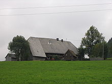
The Breitnau area is very extensive with many scattered, partly large farms , most of them with the half-hipped roof typical of the Black Forest . The actual town center is comparatively small, but has been increasing in recent years. The highest mountain is the Weißtannenhöhe .
Community structure
The Breitnau community includes the villages of Hinterdorf, Steig (part of Breitnau since 1935) and Vorderdorf, the Zinken Beim Löwen, Bisten (partly also part of Hinterzarten ), Bruckbach, Eckbach, Einsiedel, Fahrenberg, Freyel, Hintereck, Hirschsprung , Höllsteig, Hohlengraben, Jungholz -Föhrwald, Löffeltal, Moos, Oberhöllsteig, Ödenbach, Posthalde, Ravenna (gorge) , Siedelbach (after 1860 to Breitnau), Tiefen, Winterhalden and Wirbstein, the farms Haberstrohhof, Holzhof, Kuhnenbach, Schuhmächerlehof and Zimmeracker and the residential areas Bäuerleshütte, Birklehof ( partly also to Hinterzarten), Eckerhäusle, Falkenfreyel, Hundsschachen, Jockelhäusle, Jörgenhäusle, Nessellachen and Paulyhäusle.
Protected areas, nature
Breitnau is located in the Southern Black Forest Nature Park . Both the nature reserves are located in the municipality of Breitnau
- 3.267 Dreherhofmoor and
- 3.129 Deer Bog
as well as parts of the landscape protection areas
- 3.15.026 Breitnau-Hinterzarten ,
- 3.15.031 St. Peter, St. Märgen ,
- 3.15.033 Titisee-Neustadt and
- 3.15.005 Wagensteig-Höllental
as well as parts of the FFH area
- 8114-341 Black Forest around Hinterzarten
and the European bird sanctuary
- 8114-441 Southern Black Forest .
history
Breitnau was first mentioned in a document in 1275 as Breittnowe . The first church in town was built around 1200, and the St. Oswald Chapel was consecrated as early as 1148. The area was then owned by the von Falkenstein family . In 1408 the now impoverished Falkensteiners sold their property to Messrs. Schnewlin von Landeck . At the beginning of the 16th century the place went to the Lords of Sickingen .
In 1688, at the instigation of Margrave Ludwig Wilhelm von Baden, entrenchments were built to stop French troops. This effort was in vain, however, as the French raided the place two years later and burned down the rectory and 14 farms. In 1755, the poor road connection through the Höllental was expanded for the first time in order to enable Princess Marie Antoinette's bridal procession to travel as much as possible on the Austrian front on their way to Paris . After 1806 the Lords of Sickingen sold Breitnau to the newly established Grand Duchy of Baden .
Religions
There is evidence of a church in the village since around 1200. Today's Catholic parish church is consecrated to St. John and dates from 1753.
The nearest Protestant church is St. Jakob in Hinterzarten.
politics
The municipal council consists of ten members who were newly elected on May 26, 2019 with a turnout of 71.3% (2014: 61.7%). List A received 5 seats with 50.6% of the votes (previously 4) and List B with 49.4% of the votes also received 5 seats (previously 6). The committee now consists of three women and seven men (2014–2019: 4 women, 6 men).
Mayor was Wolfgang Schlachter until August 31, 2009. Josef Haberstroh (non-party) was elected as the new mayor on July 5, 2009 and took office on September 1, 2009. On July 2, 2017, he was re-elected with 78 percent of the votes in the first ballot and thus began his second term. There were no competitors for the office. The turnout was 51 percent.
Breitnau is connected to the neighboring village of Hinterzarten to the south by an agreed administrative association and a tourism advertising association. However, each municipality has its own primary school, the Carl Ludwig Magon School in Breitnau and the Georg Thoma School in Hinterzarten.
Economy and Infrastructure
Breitnau lives mainly from forestry and grazing . In the vicinity of the federal highway 500 , tourism also plays a rather minor role. In summer Breitnau is suitable for hiking. Assuming clear weather, there are wide views over the Rhine plain and the Vosges beyond . Although the terrain is a kind of plateau in large areas, there are steep paths down to the Höllental or through the Ravennaschlucht . In winter Breitnau is the trail Thurnerspur and the connection to the cross-country skiing track Schonach - Hinterzarten for cross-country skiing. Three small ski lifts are suitable for local downhill skiing.
Breitnau has been recognized as a health resort since 1970 .
traffic
Away from the town center, Breitnau is passed by the B 500 ( Black Forest High Road ) that runs through the Black Forest from north to south .
Since May 21, 1887, the Höllentalbahn has been connecting Breitnau with its train station in Hinterzarten with the national rail network. The former train stations Hirschsprung, Posthalde and Höllsteig (near the Ravennaschlucht) have not been served since the beginning of the 1980s. The connection from Breitnau to Hinterzarten train station is provided by the bus line 7216 (Freiburg - St.Peter - St. Märgen - Breitnau - Hinterzarten) operated by the Südbadenbus company. Breitnau is also served by the 7261 bus (Neustadt - St. Märgen).
Culture and sights
The Hirschsprung is a gorge-like narrowing of the Hell Valley.
The Ravennabrücke at the lower end of the Ravennaschlucht, a railway viaduct of the Höllentalbahn, is worth seeing . Below the viaduct is the Hotel Hofgut Sternen , which has existed for over 250 years. There already stayed Johann Wolfgang von Goethe (1779) and Felix Mendelssohn Bartholdy (1837). In 1770, Marie-Antoinette passed by the Hofgut Sternen with a large number on her bridal trip. A glass factory is located in a side building.
Nearby is the 800 year old, listed chapel of St. Oswald with its late Gothic altar, which belongs to the Catholic community of Hinterzarten. It is considered to be the oldest surviving parish church in the Upper Black Forest.
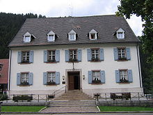
Also worth seeing is the old rectory next to the village church of St. Johann Baptist , which has been largely restored to its original state.
Personalities
- Alois Faller (* 1812 in Höllsteig; † 1882 in New York ), lawyer, revolutionary and parliamentarian
- Lorenz Helmle (* 1783 in Breitnau, † 1849 in Freiburg im Breisgau), glass painter
- Andreas Helmle (* 1784 in Breitnau; † 1839 in Freiburg im Breisgau), glass painter
- Bernhard Wangler (* 1902; † 1977 in Breitnau), mayor from 1945 to 1965
- Carl Mühl (born January 11, 1869 in Breitnau; † March 23, 1955), entomologist
- Conrad Ruf (* 1840 in Breitnau; † 1922 in Freiburg im Breisgau), photographer
- Martin Wangler (* 1969 in Freiburg im Breisgau), actor and cabaret artist, lives with his family in Breitnau
literature
- Helmut Heitzmann: Höfechronik Breitnau . Breitnau community, Breitnau 2004, ISBN 978-3-00-014512-4 .
- Horst Friedrich Vorwerk: Breitnau: a journey through past and present . Schönbergverlag, Freiburg 1986, DNB 871414848 .
Individual evidence
- ↑ State Statistical Office Baden-Württemberg - Population by nationality and gender on December 31, 2018 (CSV file) ( help on this ).
- ↑ Dieter Maurer: Breitnau: Fire Department and Sewage. Badische Zeitung, July 30, 2011, accessed on June 27, 2017 .
- ^ Andreas Haasis-Berner, Johannes Lauber, Ute Seidel; Regional Council Freiburg Division 26 - Monument Preservation: Baroque entrenchments in the Black Forest. The defenses on the Black Forest heights. Between Höllental and Wilder Gutach Valley . In: Preservation of monuments in Baden-Württemberg . tape 39 , no. 1 , 2010, p. 29 ( pdf [accessed November 24, 2018]).
- ↑ Michael Dörfler: Will the ghost train station in Höllental be renovated? In: Badische Zeitung (Upper Black Forest edition) . October 25, 2019, p. 24 ( badische-zeitung.de [accessed on October 28, 2019]).
- ↑ Susanne Gilg: Visible traces to this day. Badische Zeitung, November 29, 2017, accessed on December 27, 2018 .


