
St. Peter (Black Forest)
| coat of arms | Germany map | |
|---|---|---|

|
Coordinates: 48 ° 1 ' N , 8 ° 2' E |
|
| Basic data | ||
| State : | Baden-Württemberg | |
| Administrative region : | Freiburg | |
| County : | Breisgau-Upper Black Forest | |
| Height : | 716 m above sea level NHN | |
| Area : | 35.93 km 2 | |
| Residents: | 2625 (Dec. 31, 2018) | |
| Population density : | 73 inhabitants per km 2 | |
| Postal code : | 79271 | |
| Area code : | 07660 | |
| License plate : | FR | |
| Community key : | 08 3 15 095 | |
| Address of the municipal administration: |
Klosterhof 12 79271 St. Peter |
|
| Website : | ||
| Mayor : | Rudolf Schuler | |
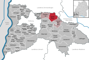
| Location of the municipality of St. Peter in the Breisgau-Hochschwarzwald district | ||
  |
||

St. Peter is a municipality in Baden-Württemberg and belongs to the Breisgau-Hochschwarzwald district .
geography
location
St. Peter is located in the Southern Black Forest Nature Park . The climatic health resort, located on the southern flank of the Kandel , is about 14 km east of Freiburg im Breisgau .
Community structure

The municipality of St. Peter includes the village of Bürgerschaft, the hamlet of Sägendobel, the Zinken Kandelberg, Neuwelt, Oberibental, Ränke, Rohr, Schmittenbach, Schönhöfe, Seelgut and Willmendobel and the farms of Eckpeterhof, Langeck and Lindlehof.
natural reserve
The protected landscape area No. 3.15.031 St. Peter, St. Märgen almost completely encompasses the municipality of St. Peter. A small part of the nature reserves Häuslematt and Zweribach are located in the St. Peter district. Many FFH areas are designated along the local rivers . There are also a number of biotopes and natural monuments to be found.
history
The monastery of St. Peter in the Black Forest was founded in 1093 by the Zähringer duke Berthold II as a house monastery and burial place. The community gradually developed around the monastery.
In the course of the Thirty Years' War, on August 10, 1644, there were clashes between the opposing parties in the St. Peter area .
When the secular rights of the monastery were abolished in 1806 as part of secularization , the village of St. Peter came to the Grand Duchy of Baden , and since 1952 it has belonged to the state of Baden-Württemberg.
In 1899 there was a fire in the center of St. Peter, which destroyed 23 houses and left 150 people homeless.
At the end of the Second World War, there was a military training camp for the Hitler Youth in St. Peter .
| Population development | ||||||||||||||
|---|---|---|---|---|---|---|---|---|---|---|---|---|---|---|
| year | 1806 | 1871 | 1900 | 1925 | 1939 | 1950 | 1961 | 1970 | 1989 | 1995 | 2005 | 2010 | 2015 | |
| Residents | 1480 | 1308 | 1383 | 1378 | 1426 | 1500 | 1529 | 1797 | 2207 | 2362 | 2508 | 2547 | 2583 | |
Source: State Statistical Office Baden-Württemberg (except 1806); 1871–1970: census results
politics

Municipal council
The municipal council consists of the voluntary councilors and the mayor as chairman. The mayor is entitled to vote in the municipal council. The parish council in St. Peter has twelve members.
- The local elections on May 25, 2014 led to the following result with a turnout of 61.6% (2009: 63.7%):
|
- In the local elections on May 26, 2019 , the local council was re-elected by majority vote. Majority voting takes place if no or only one nomination has been submitted. The applicants with the highest number of votes are then elected. Among the twelve elected are two women. The turnout was 68.0%.
mayor
On October 9, 2016, the previous incumbent Rudolf Schuler was re-elected with 89.2% of the vote. He is the successor to long-time mayor Gottfried Rohrer (CDU), whose term of office ended on December 16, 2008 after 24 years.
Local government association
Together with the neighboring municipalities of Glottertal and St. Märgen , St. Peter forms the St. Peter municipal administration association.
Community partnerships
The municipality of Ebersmunster in Alsace has been St. Peters' French partner municipality since 1963 . A partnership has existed with the community of Schmölln-Putzkau in Saxony since 1990. In addition, there are friendly relationships with all Zähringer towns.
Economy and Infrastructure
economy

The place is on the German Clock Road . The manufacture of Black Forest clocks was an important line of business in St. Peter. Today, in addition to agriculture and local handicrafts, tourism also plays a decisive economic role.
St. Peter is the 16th bioenergy village in Baden-Württemberg. The local wind and solar power plants and the thermal power station operated with wood pellets and wood chips produce more electrical energy from renewable energy sources than is consumed locally. The thermal power station also supplies the core location with heating energy and hot water via a district heating network.
traffic
Three bus routes of the Südbadenbus operate via St. Peter (as of August 2020):
- Line 7216 runs every half hour on weekdays to Kirchzarten train station, and every hour via St. Märgen and Breitnau to Hinterzarten train station (on weekends with half frequency).
- Line 7205 runs every hour via Glottertal to Denzlingen train station, and four times a day to the Kandel .
- Line 7261 runs three times a day from Monday to Friday via St. Märgen, Waldau and Langenordnach to Neustadt Bahnhof .
There is a connection to long-distance passenger rail transport via the main train station in Freiburg .
The nearest airports are Basel (96 km), Strasbourg (100 km), Zurich (102 km) and Karlsruhe / Baden-Baden (117 km).
education
- The Abt-Steyrer-Schule in the village is a primary and secondary school with a technical secondary school . Other secondary educational institutions in the vicinity are the Realschule in Kirchzarten, as well as the Marie-Curie-Gymnasium in Kirchzarten and the St. Sebastian College in Stegen, also a general-education grammar school sponsored by the School Foundation of the Archdiocese of Freiburg .
- In St. Peter there is a branch of the Dreisamtal adult education center based in Kirchzarten. In addition, the Musicosophia music school is located in the village for the promotion of conscious listening to music.
- The St. Peter's monastery building houses the spiritual center of the Archdiocese of Freiburg , after its seminary was housed there from 1842 to 2006 .
Culture and sights

- The outstanding building in the village is the baroque parish church and former monastery church of St. Peter and Paul, which was built in 1724–1727 by the Vorarlberg builder Peter Thumb and furnished by Franz Joseph Spiegler and Joseph Anton Feuchtmayer . A baroque organ clock can also be found here.
- Next to it is the baroque monastery complex of St. Peter in the Black Forest with a particularly remarkable monastery library in the Rococo style , which is equipped with ceiling paintings by Benedikt Gambs (1751) and allegorical figures by the monastery sculptor Matthias Faller based on models by Johann Christian Wentzinger (1752) .
- At the foot of the church and monastery hill stands the chapel of St. Ursula, more of a small church that was consecrated in 1725 and goes back to a vow that has to do with the maintenance of the monastery. Today the evangelical reconciliation community of Stegen uses this church space for church services.
- To the southwest of the village, on the ridge of the Lindenberg (720 m above sea level) stands the small pilgrimage church of Maria Lindenberg , next to it a meeting, conference and recreation center for the Archdiocese of Freiburg and a pilgrimage restaurant. The pilgrimage to the Lindenberg has existed for over 500 years.
- The Vosges and Kapfenkapelle, two votive chapels, are located on the panoramic hiking trail between St. Peter and St. Märgen .
- Numerous Black Forest farms and mills scattered far over the district give the village the typical character of a Black Forest community.
- The Kandelhöhenweg ( Oberkirch (Baden) - Freiburg im Breisgau ) leads through St. Peter.
- The (Wuhr) Urgraben (-weg) on the St. Peter and Glottertal districts is a technical monument .
- The Balaton , a reservoir of the Zweribachwerkes lies on the border district to Simon forest on the edge of the plate .
Personalities
Honorary citizen
Due to his services to the community during his 24-year term of office, former mayor Gottfried Rohrer was awarded honorary citizenship in December 2008.
- Timotheus Knittel (1812–1887) on January 24, 1879, Regens
- Nikolaus Gihr (1839–1924) 1916, Subregens
- Benedikt Kreutz (1879–1949) January 15, 1949, President of Caritas
- Ansgar Baumeister (1873–1950) in October 1949, Regens
- Albert Füssinger (1913–1996) in July 1969, Regens
- Oskar Saier (1932–2008) in September 1977, Auxiliary Bishop / Regens Archbishop
- Klaus Stadel on February 16, 1992, Cathedral Chapter and former Regens
- Klaus Weber (1928–2007) on December 6, 1998, local chronicle and advice writer i. R.
- Gottfried Rohrer on December 14, 2008, retired Mayor D.
- Hans-Otto Mühleisen (1941) on November 7, 2019, political scientist
Sons and daughters of the church
- Georg Saum (1736–1790), late baroque painter
- Raphael von Weinzierl (1782–1864), Oberamtmann of Württemberg
- Dominik Weber (1819–1887), painter
- Wilhelm Schmidle (1860–1951), teacher, algae expert and geologist, director of the Salem boarding school
- Benedikt Kreutz (1879–1949), pastor, second president of the German Caritas Association
- Josef "Sepp" Maier (1935–2012), cross-country skier
Personalities who have worked in the church
- Ludwig Armbruster (1886–1973), priest and apologist, conducted research as director of the Institute for Apiculture in Berlin together with the local beekeeping association in the noble breeding area of Platte .
- Manfred Herrmann (1932–2012), pharmacologist, inventor of the drug Valoron and other approved drugs.
Others
A large part of the outdoor shots for the first German post-war color film Schwarzwaldmädel was shot here in May 1950.
Individual evidence
- ↑ State Statistical Office Baden-Württemberg - Population by nationality and gender on December 31, 2018 (CSV file) ( help on this ).
- ^ Health resorts in the Upper Black Forest - climatic health resorts. Retrieved August 22, 2020 .
- ^ Freiburg administrative district . In: Landesarchivdirektion Baden-Württemberg (ed.): The state of Baden-Württemberg. Official description by district and municipality . tape IV . Kohlhammer, Stuttgart 1978, ISBN 3-17-007174-2 , p. 153-155 .
- ^ Protected area profile : Landscape protection area St. Peter, St. Märgen. Retrieved August 19, 2020 .
- ↑ LUBW data and map service. Retrieved on August 19, 2020 ( LUBW interactive map ).
- ↑ a b Karl Schmid; Hans Schadek: The Zähringer. Impulse and effect. Thorbecke, Sigmaringen 1986, ISBN 3-7995-7041-1 , p. 371
- ↑ a b c local history. Retrieved August 22, 2020 .
- ^ Working group Ebringer village history (ed.): Ebringer village history no. 2. E Bring under the swastika. Contemporary witness reports , Ehaben 2008, pp. 33 and 38
- ↑ regional data . statistik.baden-wuerttemberg.de. Retrieved November 3, 2019.
- ^ Jumelages France - Bade-Wurtemberg. Retrieved on August 19, 2020 (French).
- ↑ The building of the library stood still in the shell for several years because the monastery farmers refused to provide the necessary services in forced labor.
- ↑ Thomas Biniossek: Hans-Otto Mühleisen becomes an honorary citizen of St. Peter . In: Badische Zeitung . November 12, 2019 ( badische-zeitung.de [accessed May 10, 2020]).
Web links
Germany: Bräunlingen | Freiburg im Breisgau | Neuchâtel am Rhein | Offenburg | St. Peter | Villingen | Weilheim an der Teck
Switzerland: Bern | Burgdorf | Freiburg | Murten | Rheinfelden | Tuna