
Bundeskanzlerplatz
The Bundeskanzlerplatz is a transport space in Bonner district Gronau , where the Reuterstraße the Federal Highway 9 opens. The geographic center of the city of Bonn is located at Bundeskanzlerplatz.
Location and traffic relations
The square is located on the western edge of the federal district , the former parliament and government district, according to the German basemap at a height of 62.6 m above sea level. NHN . The junction to Reuterstraße, a main road leading to the 565 federal motorway , crosses under the B 9 in the direction of Bad Godesberg . The flow of traffic is regulated by numerous traffic lights. North of Bundeskanzlerplatz, the B 9 is called Adenauerallee , and south of the square has been Willy-Brandt-Allee since 1999 .
history

At today's Bundeskanzlerplatz, at the intersection of Reuterstraße / Koblenzer Straße at that time, the southern terminus of the first stretch of Bonn's horse-drawn tram has been located since 1891 . The crossing was also the temporary end point of the single track 1892 opened and steam-driven railway to Bad Godesberg that in 1893 by the Kaiser road along the realm railway line was extended to the north. It was the forerunner of the Bonn – Godesberg – Mehlem tram . The horse-drawn tram was run from today's Bundeskanzlerplatz to the newly built Rheinlust restaurant in 1896 and then extended over the Rheinweg to Kessenich , but was completely stopped by 1907 in favor of tram operation. In 1937, the crossing gained in importance with the opening of the nearby Reuterbrücke , the bridge on Reuterstraße over the railway line on the left bank of the Rhine.
After Bonn had become the seat of government of the Federal Republic of Germany in 1949 , the intersection was in the center of the newly created parliament and government district . The Görresstrasse branching off from it, as an extension of Reuterstrasse, was the entrance to the Federal Chancellery and the Federal Palace . The junction was now regulated by a traffic police post. In 1956 the tram was given a separate track in the middle of the B 9. The naming of the square was made on December 7, 1967 by a resolution of the Bonn City Council.
The square got its current appearance with the expansion of Reuterstraße to a four-lane main thoroughfare from 1958/59 to 1964 including the construction of the underpass of the federal highway 9 in the direction of Bad Godesberg as well as the construction of the adjacent large buildings ( Bonn-Center and Federal Chancellery ) at the end of the 1960s. until the mid-1970s. For the construction of the new Federal Chancellery (1973–76), Görresstrasse and Görreswiese were pulled in and built over (today only a part of Dahlmannstrasse exists ). Since the opening of the new tram tunnel in 1975, the trams have been running below Bundeskanzlerplatz. In 2005 an urban development competition was planned for the redesign of the Bundeskanzlerplatz including the removal of the ramps.
Buildings and sights
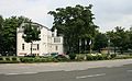
Immediately to the east of the square is the former Federal Chancellery building, which was built from 1973 to 1976 (today the seat of the Federal Ministry for Economic Cooperation and Development ), to which the Palais Schaumburg adjoins to the north . On the western edge of the square, the Bonn-Center , built in 1968/69, was the fourth tallest building in Bonn, which was blown up in March 2017 and is to be replaced by a new building. At the northwest corner of Bundeskanzlerplatz are the Villa Adenauerallee 212/214 (seat of the International Paralympic Committee ) and the listed SAS pavilion from 1952, which is now the location of a car rental company and is a curiosity in terms of architectural history. The double villa Willy-Brandt-Allee 4/6 , which was built in 1912/13 and is a listed building, forms the southern end of the square . Between the double villa and the Bonn-Center, the location of the Kultkneipe Provinz was until 1992 .
In May 1982, a head sculpture by Konrad Adenauer (sculptor: Hubertus von Pilgrim ), which is considered a symbol of the Bonn Republic , was erected outside the Federal Chancellery .

Former Federal Chancellery

Former development: Bonn Center with Pantheon Theater
Seat of the IPC and SAS pavilion

SAS pavilion

Adenauerplastik

Double villa Willy-Brandt-Allee 4/6


.JPG)


Web links
Individual evidence
- ^ The city area , statistical office of the Federal City of Bonn
- ↑ Traffic policeman in front of the Federal Chancellery (picture from September 18, 1961) , Wikimedia Commons
- ↑ The Minister and the Policeman , Die Zeit , No. 37/1958, September 11, 1958
- ^ Entry in the Bonn street cadastre
- ^ Franz Josef Talbot (with photographs by Achim Bednorz): Bonner Südstadt . Emons Verlag, Cologne 2018, ISBN 978-3-7408-0468-8 , p. 189.
- ↑ Bonner Bundeskanzlerplatz is to be revamped , General-Anzeiger , April 15, 2005
Coordinates: 50 ° 43 '8.7 " N , 7 ° 7' 2.7" E