Chicot County
 Chicot County Courthouse |
|
| administration | |
|---|---|
| US state : | Arkansas |
| Administrative headquarters : | Lake Village |
| Address of the administrative headquarters: |
County Courthouse 108 North Main Street Lake Village, AR 71653-1965 |
| Foundation : | October 25, 1823 |
| Made up from: | Arkansas County |
| Area code : | 001 870 |
| Demographics | |
| Residents : | 11,800 (2010) |
| Population density : | 7.1 inhabitants / km 2 |
| geography | |
| Total area : | 1789 km² |
| Water surface : | 121 km² |
| map | |
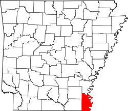
Chicot County is the southeasternmost county in the state of Arkansas in the United States . The county seat is Lake Village .
geography
The county is in the extreme southeast of Arkansas; it is bordered to the east by the Mississippi River , which forms the border with the state of Mississippi , and to the south by Louisiana . Chicot County covers an area of 1789 square kilometers, of which 121 square kilometers are water. It is bordered by the following counties and parishes:
| Drew County | Desha County | |
| Ashley County |

|
Washington County, Mississippi |
|
West Carroll Parish, Louisiana |
East Carroll Parish, Louisiana |
Issaquena County, Mississippi |
Hydrology
The same aquifer with a dimension larger than the German State of Hesse is the largest aquifer of the gulf coast aquifer ( Gulf Coast aquifer ). It supplies cities and municipalities in the region with drinking water and is used to irrigate the rice fields in the area and to raise freshwater mussels. Due to years of overexploitation with water abstraction above the rate of new groundwater formation , the land above sinks: Saltwater intrusion displaces the dwindling freshwater, so that salt water is pumped from regional drinking water wells more and more frequently and sometimes completely surprisingly.
history
| growth of population | |||
|---|---|---|---|
| Census | Residents | ± in% | |
| 1830 | 1165 | - | |
| 1840 | 3860 | 231.3% | |
| 1850 | 5115 | 32.5% | |
| 1860 | 9234 | 80.5% | |
| 1870 | 7214 | -21.9% | |
| 1880 | 10.117 | 40.2% | |
| 1890 | 11,419 | 12.9% | |
| 1900 | 14,528 | 27.2% | |
| 1910 | 21,987 | 51.3% | |
| 1920 | 21,749 | -1.1% | |
| 1930 | 22,646 | 4.1% | |
| 1940 | 27,452 | 21.2% | |
| 1950 | 22.306 | -18.7% | |
| 1960 | 18,990 | -14.9% | |
| 1970 | 18.164 | -4.3% | |
| 1980 | 17,793 | -2% | |
| 1990 | 15,713 | -11.7% | |
| 2000 | 14,117 | -10.2% | |
| 2010 | 11,800 | -16.4% | |
| 1830-1890 1900-1990 2010 | |||
Chicot County was formed on October 25, 1823 from parts of Arkansas County. The name comes from the French word chicot for the cypress trees along the river.
In the years leading up to the Civil War , Chicot County was known as the richest county in Arkansas and one of the richest counties in the country. By 1850, 145 white families had 3,984 slaves. In percentage terms, this was the highest ratio in the country. Only Union County had more slaves. In 1860, Chicot County produced 40,948 bales of cotton at a maximum price of 12.4 cents a pound.
The trade was favored by several ports along the Mississippi . Probably the most important landing point between 1830 and 1880 was Gaines Landing , named after Ben P. Gaines, RM Gaines and William H. Gaines . In 1903 the area got a connection to the Memphis, Helena, Louisiana Railroad , which resulted in faster population growth. The 1927 Mississippi Flood flooded 13 percent of Arkansas and destroyed most of Chicot County's farmland.
During World War II, one of the ten internment camps for Japanese immigrants in Chicot County was set up. In June 1944, 8,497 people were housed here.
Demographic data
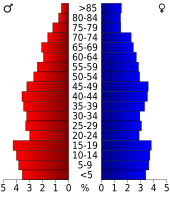
According to the 2000 census , Chicot County had 14,117 people; 5,205 households and 3,643 families were counted. The population density was 8 people per square kilometer. The racial the population was composed of 43.24 percent white, 53.96 percent African American, 0.13 percent Native American, 0.40 percent Asian, 0.02 percent from the Pacific island area and 1.41 percent from other ethnic groups Groups; 0.85 percent were descended from two or more races. Hispanic or Latino of any race was 2.88 percent of the population.
Of the 5,205 households, 31.7 percent had children or adolescents under the age of 18 living with them. 43.7 percent were married couples living together, 22.0 percent were single mothers, 30.0 percent were non-families. 26.9 percent of all households were single households and 13.0 percent had people aged 65 or over. The average household size was 2.58 and the average family size was 3.12.
27.5 percent of the population were under 18 years old, 8.6 percent between 18 and 24, 26.4 percent between 25 and 44, 22.2 percent between 45 and 64 and 15.4 percent were 65 years or older. The median age was 36 years. For every 100 females there were 94.2 males and for every 100 females aged 18 and over there was an average of 89.9 males.
The median income for a household in the 22,024 USD , and the median income for a family 27,960 USD. Males had a median income of $ 25,899 versus $ 17,115 for females. The per capita income was $ 12,825. 23.1 percent of families and 28.6 percent of the population lived below the poverty line.
Places in Chicot County
Web links
Individual evidence
- ↑ GNIS-ID: 69160. Retrieved on February 22, 2011 (English).
- ↑ academic.emporia.edu: Gulf Coast Aquifer, Texas (November 4, 2015)
- ↑ deutschlandfunk.de , Research News , November 4, 2015, Dagmar Röhrlich : Strategies against Shrinkage (November 4, 2015)
- ^ US Census Bureau _ Census of Population and Housing.Retrieved February 17, 2011
- ^ Extract from Census.gov.Retrieved February 15, 2011
- ↑ United States Census 2010.Retrieved April 18, 2011
- ^ Extract from the Encyclopedia of Arkansas.Retrieved February 12, 2011
- ↑ Chicot County, Arkansas Datasheet with the results of the 2000 census at factfinder.census.gov
Coordinates: 33 ° 18 ′ N , 91 ° 17 ′ W

