
Duppach
| coat of arms | Germany map | |
|---|---|---|

|
Coordinates: 50 ° 16 ' N , 6 ° 34' E |
|
| Basic data | ||
| State : | Rhineland-Palatinate | |
| County : | Vulkaneifel | |
| Association municipality : | Gerolstein | |
| Height : | 461 m above sea level NHN | |
| Area : | 10.28 km 2 | |
| Residents: | 287 (Dec. 31, 2019) | |
| Population density : | 28 inhabitants per km 2 | |
| Postal code : | 54597 | |
| Area code : | 06558 | |
| License plate : | DAU | |
| Community key : | 07 2 33 211 | |
| Association administration address: | Kyllweg 1 54568 Gerolstein |
|
| Website : | ||
| Local Mayor : | Gottfried Wawers | |
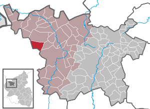
| Location of the local community of Duppach in the Vulkaneifel district | ||
  |
||

Duppach in the Vulkaneifel is a municipality in the Vulkaneifel district in Rhineland-Palatinate . It belongs to the Gerolstein community .
geography
The Duppach district is located at an altitude between 400 and 600 m above sea level. NHN , whereby the place itself is in a valley at 460 m . The Weiermühle residential area belongs to the community . The towns of Hillesheim and Gerolstein are 10 km away. It is 13 km to the city of Prüm .

;_Panoramablick_Duppach_a.jpg)
history
During archaeological excavations starting in 2002, the remains of a Roman villa and two large grave monuments were found in the Weiermühle district. Through the Archäologische Förderverein Duppach e. V. (founded in 2003) the excavations are carried out at irregular intervals. The excavation manager is Peter Henrich .
As part of the Rhineland-Palatinate functional and territorial reform, Duppach was reclassified together with 14 other communities on November 7, 1970 from the district of Prüm , which was dissolved at the same time, to the district of Daun (since 2007 district Vulkaneifel).
- Population development
The development of the population of Duppach, the values from 1871 to 1987 are based on censuses:

|
|
politics
Municipal council
The municipal council in Duppach consists of six council members, who were elected by a majority vote in the local elections on May 26, 2019 , and the honorary local mayor as chairman. Until 2014, the council had eight councilors.
coat of arms
|
|
Blazon : “Divided by a wave cut from gold over blue; above a growing black, red-armored lion, below two silver stag poles, enclosing a golden cross. " |
| Justification of the coat of arms: The lion in the upper part of the coat of arms refers to the former sovereigns, the noble lords of Blankenheim. Saint Hubertus is the church patron of Duppach, and the stag sticks and the cross indicate him. The wave cut symbolizes the numerous streams that surround the place. |
Culture and sights

;_r%C3%B6mische_Villa_von_Duppach-Weierm%C3%BChle_l.jpg)

Buildings
- Cemetery chapel from 1551 - choir of the former Catholic parish church from 1330
- Catholic parish church of St. Hubertus from 1923
- Roman necropolis (burial site) and villa complex of Duppach-Weiermühle
- Archaeological information center ( ⊙ ) on the excavation site of Duppach-Weiermühle (replica of a Roman 6-post storage building)
- " Adenauervilla " - ruins of a villa for Konrad Adenauer in the Duppacher Kammerwald from 1955/1956 ( ⊙ )
Green spaces and recreation
- Adventure forge and historical sawmill
- Hiking trails around Duppach
- Freely accessible mineral fountain "Duppacher Drees" ( ⊙ )
- "Duppacher Maar" - a 1930 drained pond that was once rich in fish
- To the north between Duppach and Steffeln is the Eichholzmaar with the mineral springs “Steffelner Drees” and “Aueler Drees”.
Regular events
- Annual fair or parish fair on the name day of St. Hubert, usually on the second weekend in November. A mandatory requirement for the beginning of the fair is the excavation of the "Kirmes-Knooch" (skull of a bull's head with horns).
See also: List of cultural monuments in Duppach
See also: List of natural monuments in Duppach
Born in Duppach
- Klaus-Peter Müller (* 1944), Chairman of the Supervisory Board of Commerzbank AG
Web links
- Internet presence of the local community Duppach
- To search for cultural assets of the local community of Duppach in the database of cultural assets in the Trier region .
- Portrait of Duppach in Hierzuland ( SWR )
Individual evidence
- ↑ State Statistical Office of Rhineland-Palatinate - population status 2019, districts, communities, association communities ( help on this ).
- ↑ Official municipality directory (= State Statistical Office of Rhineland-Palatinate [Hrsg.]: Statistical volumes . Volume 407 ). Bad Ems February 2016, p. 156 (PDF; 2.8 MB).
- ↑ State Statistical Office Rhineland-Palatinate - regional data
- ^ The Regional Returning Officer Rhineland-Palatinate: Local elections 2019, city and municipal council elections
- ↑ Declaration of the coat of arms. Retrieved June 11, 2017 .
- ↑ Weiermühle excavation site. Retrieved June 10, 2017 .
- ↑ Adventure forge and historical sawmill. Retrieved June 10, 2017 .
- ↑ GEO circular route Duppach. Retrieved June 10, 2017 .
- ↑ Duppacher Drees. Retrieved June 10, 2017 .
- ↑ To the Duppacher Weiher
- ↑ Entry on Vulkan Duppacher Weiher in the database of cultural assets in the Trier region ; accessed on December 23, 2015.
- ↑ Duppacher Weiher, Trockenmaar
- ↑ Fairground Knooch. Retrieved June 1, 2017 .

Arbach | Basberg | Beinhausen | Bereborn | Berenbach | Berlingen | Berndorf | Betteldorf | Birgel | Birresborn | Bleckhausen | Bodenbach | Bongard | Borler | Boxberg | Brockscheid | Brückal | Darscheid | Down | Demerath | Densborn | Deudesfeld | Dockweiler | Dohm-Lammersdorf | Drees | Dreis-Brück | Duppach | Ellscheid | Esch | Feusdorf | Gefell | Gelenberg | Gerolstein | Gillenfeld | Gönnersdorf | Gunderath | Reverberation | Hillesheim | Hinterweiler | Höchstberg | Hohenfels-Essingen | Horperath | Hörscheid | Hörschhausen | Immerath | Jünkerath | Kalenborn scrubbing | Caperich | Katzwinkel | Kelberg | Kerpen (Eifel) | Kerschenbach | Kirchweiler | Kirsbach | Kolverath | Kopp | Kötterichen | Kradenbach | Lirstal | Lissendorf | Mannebach | More | Meisburg | Mosbruch | Mosquitoes | Mürlenbach | Neichen | Nerd | Neroth | Niederstadtfeld | Nitz | Nohn | Oberbettingen | Oberehe-Stroheich | Oberelz | Oberstadtfeld | Ormont | Pelm | Reimerath | Retterath | Reuth | Rockeskyll | Salm | Sarmersbach | Sassen | Saxler | Schalkenmehren | Scheid | Schönbach | Schüller | Protection | Stadtkyll | Steffeln | Steineberg | Steiningen | Strohn | Strotzbüsch | Üdersdorf | Udler | Uersfeld | Ueß | Utzerath | Üxheim | Wallenborn | Walsdorf | Weidenbach | Which council | Wiesbaum | Winkel (Eifel)