
Elster flood 2010

The Elster flood was a flood event classified as a century flood in 2010 on the Black Elster and its tributaries.
root cause
August 2010 was characterized by low pressure areas in the Atlantic , which brought precipitation with prolonged heavy rain , especially in the catchment area of the Black Elster . The cause of the long and heavy rainfall was a Vb weather condition . The air masses deviate from their usual west-east direction towards the Mediterranean to the south. This is where these air masses heat up and absorb a lot of moisture. After crossing the Alps towards the north, they encounter the cold air there, cool down considerably, and extreme precipitation occurs in a relatively short time. This weather situation was also the cause of the Oder floods ( 1997) and the Elbe floods (2002).
course


From September 24, 2010 there was extensive heavy rainfall in the Elbe-Elster region . Between the Fläming and the Saxon Upper Lusatia fell in the days from September 24th to September 27th, sometimes more than 100 liters of rain per square meter.
As a result, flood warning level 4 was reached on September 29 on the Schwarzen Elster and its two tributaries, the Große Röder and Pulsnitz, which flow into Elsterwerda . After alert level 3 had to be called the day before in the entire Elbe-Elster district and a crisis team was formed, District Administrator Christian Jaschinski had to trigger a disaster alarm at 11.50 a.m. that day . As the water level continued to rise, preparations began in Elsterwerda, where the water level of the Black Elster had risen to around 3.50 meters, to prepare for the voluntary evacuation of the inner city, which threatened to flood.
At the official level in Bad Liebenwerda , about ten kilometers downstream, 3.50 meters were also measured. Towards evening the tense situation required that the first roads and bridges had to be closed. While the newly built, important Elsterbrücke in Elsterwerda remained open, bridges across the Schwarze Elster in Saathain and Bad Liebenwerda as well as the partially flooded federal highway 169 near Plessa , the district road 6207 between Saathain and Stolzenhain and the through-road from Schmerkendorf had to be closed. At Ortrand , where the Pulsnitz overflowed , the A 13 motorway had to be closed due to flooding.
The worsening situation now also ensured increased media interest, so that several television teams from the public and private radio and television companies reported with live broadcasts from the region.
On Thursday, September 30th, all schools in Elsterwerda, Bad Liebenwerda and Herzberg, as well as the schools in Annaburg, were closed to the students affected by the flood. On this day, maximum water levels were finally measured at all gauges located on the Schwarzen Elster and record values never before reached. The measured peak discharge of the Schwarzen Elster in Löben was now 128 m³/s, which corresponds to a discharge parameter of HQ 200. The water level in Bad Liebenwerda reached an all-time high of 3.55 meters during the night. From now on it began to sink slightly here, while the levels in the downstream places were still rising. The situation on the more and more softening dikes of the Black Elster remained critical. Weak spots and cracks, such as between Kotschka and Saathain, where the dike began to flood over a length of about 50 meters, were sealed as soon as possible using sandbags by the emergency services and with the help of hurrying residents.
For security reasons, the voluntary evacuation of around 2,700 residents began in Elsterwerda at this time, who were asked to leave their homes and properties by means of loudspeaker announcements from police vehicles driving through the city and public notices. The city's district hospital, located in the immediate vicinity of the river, was also evacuated using ambulances and helicopters. Around 100 patients were transferred from here within around four hours to hospitals in the vicinity such as Herzberg, Finsterwalde, Lauchhammer , Riesa, Großenhain or Dresden .
Despite all the efforts of the emergency services, the catastrophe finally occurred the following day about twenty kilometers upstream from the Elster estuary. On October 1, at around 12:50 p.m. near Meuselko, the left-hand dike of the Black Elster broke at a water level of 3.34 m, measured at the Löben gauge. A good four hours later, around 5 p.m., a disaster alarm was finally issued for the entire district of Wittenberg. Eight hours later, parts of the village of Löben , two kilometers downstream, were flooded and the Waltersdorf district cut off from the outside world.
The elongated peak of the flood ensured that the disaster alarm for the Elbe-Elster district, with the exception of the city of Herzberg / Elster, was not lifted until October 6th. On October 7th, the disaster alarm for the district of Wittenberg and the city of Herzberg was lifted when flood warning level 4 was permanently below the level at Löben. The dike near Meuselko, which was broken in a length of around 30 meters, was closed on October 5th, with the levels remaining constant and sometimes still rising.
- More pictures of the Elster flood
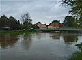
Schwarze Elster in Elsterwerda (September 29, 2010).
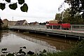
Emergency vehicle of the volunteer fire brigade in Bad Liebenwerda (September 29, 2010).

One of the hot spots in Elsterwerda, the seepage point secured with hundreds of sandbags in the area of Burgstrasse (October 3, 2010).

Flooded Schradenwiesen near Plessa (October 11, 2010).

Property in Haida secured with sandbags (October 11, 2010).

In the winter after that in Bad Liebenwerda


Damage
A final balance of the flood disaster published in 2010 recorded over 100 damaged areas on the dike for the Elbe-Elster district alone, through which 58 kilometers of the Black Elster run, which had to be secured, stabilized, increased and repaired. In addition, up to 2000 helpers were used.
The estimated damage to agriculture in Brandenburg amounted to around 3 million euros. The costs for the nine-day disaster operation in the Elbe-Elster district were given as up to 2 million euros. Immediate damage to hydraulic structures in the Wittenberg district caused by the flood is estimated at 670,000 euros. The provisionally estimated costs for the dike renovation in Brandenburg (as of 2011) are given as up to 50 million euros; the state of Saxony-Anhalt is planning a further 50 million euros for the renovation of dikes on the Black Elster by 2020. In the eastern part of the Annaburg Heath , several hectares of forest were destroyed by the five-month flooding and a high groundwater level caused by the flood .
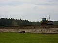
- Dike renovation work on the Black Elster in 2012

Dike construction site near Zeischa

Dike construction site between Liebenwerda and Wahrenbrück

Black Elster dike construction site near Mönchenhöfe

Note dike construction site Schwarze Elster
Dike construction site Schwarze Elster Kremitz


Further floods on the Black Elster in the past
Due to the strong straightening of the river bed , which mostly took place in the middle of the 19th century, the Black Elster now runs as a canal through the landscape. The extensive floodplain forests adjacent to the river and the meandering course of the Black Elster disappeared, recurring floods no longer had the opportunity to use them as compensation areas, so the levels rose with every flood, which led to a further expansion of the flood protection systems.
Just a few years after the regulation of the Black Elster had begun, the newly built dykes broke in 1861 as a result of flooding. In the years 1862, 1871, 1895 and 1907 there were also reports of floods on the river.
Another devastating flood on the Black Elster became known from 1926. A Röder dam breach near the small town of Würdenhain flooded the entire town on June 18, 1926. With Röder, Pulsnitz, Schwarzer Elster and Kleiner Elster, the flood affected almost all rivers in the area and caused enormous damage. In that year, two thirds of the harvest were destroyed in the floodplain of what was then the Bad Liebenwerda district . Downstream in the Mönchenhöfe area, up to 144 hectares of flooded area are reported. In June of the following year, during the summer floods near Mückenberg ( Lauchhammer-West ), the Elster dam broke, which could only be closed again with great difficulty.
Literature and publications
- Author and photographer community: Schwarze Elster - Uferlos. The record flood in 2010 . 1st edition. Books Chamber, Herzberg (Elster) 2010, ISBN 978-3-940635-26-6 .
- Report on the August / September / October 2010 flood by the State Office for Flood Protection and Water Management Flood Forecast Center (HVZ) in Saxony-Anhalt ( online as a PDF file )
Footnotes and individual references
- ↑ http://www.hochwasservorhung.sachsen-anhalt.de/
- ^ Author and photographer community: Black Elster - Uferlos. The record flood in 2010 . 1st edition. Books Chamber, Herzberg (Elster) 2010, ISBN 978-3-940635-26-6 , pp. 97 .
- ↑ State Office for Flood Protection and Water Management Saxony-Anhalt: "Report on the floods August / September / October 2010" ( Online as PDF file ( Memento of the original from December 28, 2015 in the Internet Archive ) Info: The archive link was automatically inserted and still not checked. Please check the original and archive link according to the instructions and then remove this note. )
- ↑ "Flood protection conception of the state of Saxony-Anhalt until 2020" ( online as a PDF file ( memento of the original from January 16, 2016 in the Internet Archive ) Info: The archive link was inserted automatically and has not yet been checked. Please check the original and archive link according to the instructions and then remove this notice. )
- ↑ Black Elster - Shoreless. The record flood in 2010
- ↑ Rudolf Matthies: "History of the village Würdenhain" . 1953 (compiled within the framework of the national construction work with subsequent additions by Ursula, Heinz and Matthias Lohse).
- ↑ G. Becker: “Floods and dam breaks near Mückenberg” in “Die Schwarze Elster” (local history supplement to the Liebenwerdaer Kreisblatt), No. 338, August 1927