
Esthal
| coat of arms | Germany map | |
|---|---|---|

|
Coordinates: 49 ° 23 ' N , 7 ° 59' E |
|
| Basic data | ||
| State : | Rhineland-Palatinate | |
| County : | Bad Dürkheim | |
| Association municipality : | Lambrecht (Palatinate) | |
| Height : | 363 m above sea level NHN | |
| Area : | 15.49 km 2 | |
| Residents: | 1310 (Dec. 31, 2019) | |
| Population density : | 85 inhabitants per km 2 | |
| Postal code : | 67472 | |
| Area code : | 06325 | |
| License plate : | DÜW | |
| Community key : | 07 3 32 016 | |
| Community structure: | 4 districts | |
| Association administration address: | Sommerbergstrasse 3 67466 Lambrecht (Palatinate) |
|
| Website : | ||
| Local Mayor : | Gernot Kuhn ( CDU ) | |
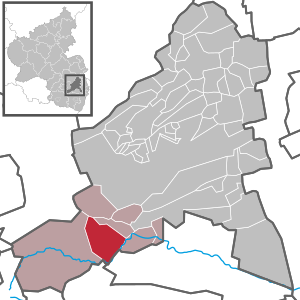
| Location of the local community Esthal in the Bad Dürkheim district | ||
  |
||


Esthal (Palatine: Eschdl) is a municipality in the Bad Dürkheim district in Rhineland-Palatinate . It belongs to the Verbandsgemeinde Lambrecht (Palatinate) , within which it is the second largest local community in terms of area.
geography
location
The community lies on a plateau in the Palatinate Forest ; the area in the area of the municipality forms the so-called Esthaler forest . Esthal also includes the Breitenstein , Erfenstein , Esthaler Forsthaus and Sattelmühle residential areas . These are all in the south-east of the municipality in the Elmsteiner Tal . Neighboring communities are - clockwise - Frankeneck , Lambrecht , Neustadt an der Weinstrasse , Kirrweiler , Elmstein and Weidenthal .
Surveys
The so-called Gleisberg massif rises directly to the southeast of the core town . It consists of the 463.1 m high Vorderen Gleisberg ; the Mittlere ( 471.2 m ) and the Hintere Gleisberg ( 467.5 m ) follow to the east . Northeast of the settlement area is the 383 m high Aschberg . The 393 m high Wassersteinberg extends in the area of Erfenstein and Breitenstein . The 506 m high Mollenkopf rises on the boundary to Weidenthal and Frankeneck .
Waters
The Speyerbach flows along the southeastern edge of the municipality . In the far south the Argenbach flows from the right and the Breitenbach from the left , which largely forms the boundary to Elmstein. The latter receives the water from the gold fountain . Further north, a brook from the Erfensteiner Tal and the Esthalbach flows into the Speyerbach from the left.
history
The place was first mentioned in 1380 as "Estall". In 1602 he received the forest area, henceforth called Esthaler Wald , which until then had been part of the Frankenweide . The community was under the rule of the Lords of Erfenstein until 1794, who had their seat in the nearby Erfenstein Castle and who in turn were subordinate to the Barons of Dalberg .
From 1798 to 1814, when the Palatinate was part of the French Republic (until 1804) and then part of the Napoleonic Empire , Esthal was incorporated into the canton of Neustadt (Donnersberg) and was the seat of a mairie , which also included Neidenfels and Frankeneck. In 1815 the place Austria was added. Just one year later, the place, like the entire Palatinate, changed to the Kingdom of Bavaria . From 1818 to 1862 the community belonged to the Landkommissariat Neustadt ; from this the district office of Neustadt emerged.
In 1928 the community had 1156 inhabitants who lived in 207 residential buildings. From 1939 Esthal was part of the district of Neustadt an der Weinstrasse . After the Second World War , the place became part of the then newly formed state of Rhineland-Palatinate within the French occupation zone . In the course of the first Rhineland-Palatinate administrative reform , the place moved in 1969 to the newly created district of Bad Dürkheim . Three years later, Esthal became part of the also newly created Verbandsgemeinde Lambrecht (Palatinate) .
religion

At the end of 2013, 66 percent of the population were Catholic and 18 percent Protestant. The rest belonged to another religion or were non-denominational. The Catholics belong to the Deanery Bad Dürkheim of the Diocese of Speyer , at the beginning of the 20th century they were subordinate to the Dean's Office Neustadt an der Haardt . By the end of 2015, the place formed its own parish, which belonged to the parish community Neustadt. Since 2016, Esthal has been part of the Lambrecht-based parish of St. John XXIII. , which includes the Verbandsgemeinde Lambrecht, the local Catholic Church forms the St. Konrad branch .
Due to their small number, the Protestants did not have their own parish in the early 20th century. Those living in the core town were subordinate to the Weidenthal parish, those from the sub-towns to the Lambrecht parish.
politics
Municipal council
The municipal council in Esthal consists of 16 council members, who were elected in the local elections on May 26, 2019 in a personalized proportional representation, and the honorary local mayor as chairman.
The distribution of seats in the municipal council:
| choice | SPD | CDU | FWG | total |
|---|---|---|---|---|
| 2019 | 4th | 9 | 3 | 16 seats |
| 2014 | 4th | 9 | 3 | 16 seats |
| 2009 | 3 | 8th | 5 | 16 seats |
| 2004 | 3 | 9 | 4th | 16 seats |
- FWG = Free Voting Group Talgemeinden e. V.
mayor
The local mayor is Gernot Kuhn (CDU). In the direct election on May 26, 2019, he was confirmed in his office with a share of the vote of 66.80 percent. Before that, his party colleague Otmar Blum accompanied this office from 1979 to 1996.
coat of arms
|
|
Blazon : "Under a silver shield head in black a floating, ball-studded golden paw cross"
It was approved by the Rhineland-Palatinate Ministry of the Interior in 1954 and goes back to a court seal from 1772. |
Culture and sights
Cultural monuments

The ruins of the Erfenstein and Breitenstein castles in the Esthal area are designated as monument zones.
There are also several individual monuments, including the monastery of St. Maria of the Niederbronn Sisters of the Divine Redeemer on the outskirts of the village , which was built between 1951 and 1959 and served as the Provincial Mother House until 2005. Since then it has served as a church education center. Since 2010, the monastery has also been accepting boarders and pilgrims. In the center of the village on Kirchstrasse is the Catholic Church of St. Konrad von Parzham , built in 1933 and 1934 , the nave of which is attached to the previous Baroque church. Its classical high altar comes from the priest sculptor Bernhard Würschmitt . There are several historical wash fountains in Brunnenstrasse and in the vicinity of Esthal .
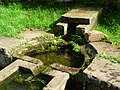
Wash fountain on the outskirts

Breitenstein ruins


nature

There are a total of six natural monuments in the parish of the municipality , including the gold fountain. The Mittlere Gleisberg forms one of 16 core zones of the Palatinate Forest Nature Park and covers a total of 37 hectares. Ritterstein 113 is at the level of the hamlet of Breitenstein . It bears the inscription R. Breitenstein 500 Schr. And indicates the castle ruins there.
societies
With the ASV Esthal there is a local football club. There is also a local branch of the Palatinate Forest Association .
Economy and Infrastructure
economy
Due to the geographical conditions, forestry dominated the area. The community is also the seat of the Gerhard Kuhn Orgelbau company . Säge- und Hobelwerk Fath GmbH Co. KG is based in Breitenstein .
traffic

rail
The Kuckucksbähnel , which runs from Lambrecht to Elmstein , has existed since 1909 ; the section up to the saddle mill was opened as an industrial track as early as 1902. This resulted in train stations in Sattelmühle - called Sattelmühle-Esthal , later Esthal -, in Erfenstein near the castle ruins and in Breitenstein. In 1960 passenger traffic, which had always played a subordinate role on the route, was discontinued, freight traffic followed in 1977. Since 1984 the route has served as a museum railway; however, there was no reactivation of the operating site at the Sattemühle level.
Street
A historical connection ran from Speyer to Metz via Esthal . The state road 499 runs from Frankeneck to Waldfischbach-Burgalben through the southeast of the municipality . From this, the district road 23 , which connects the town to the road network, and in Breitenstein, the state road 514 , the so-called Totenkopfstraße , branch off . The bus line 517 of the Rhein-Neckar transport association, which runs from Neustadt an der Weinstraße to Iggelbach , also connects the community to the local transport network.
tourism

The community is on the route of several hiking trails, one of which is marked with a green and white bar and leads from Hertlingshausen to Sankt Martin . Another is marked with a white-red bar and establishes the connection with Kaiserslautern as well as Neustadt an der Weinstrasse and Speyer . There is also a route marked with a white-green bar , which leads from the Obere Eselsmühle in Enkenbach-Alsenborn to Maikammer . In addition, a path marked with a yellow-red bar runs from Lichtenberg Castle to Wachenheim via the municipal area of Esthal.
In the Breitenbach valley on the border with Elmstein, the Esthaler local group of the Palatinate Forest Association operates the Wolfsschluchthütte , inaugurated in 1961 at an altitude of 285 meters , which is open on Wednesdays, Saturdays, Sundays and public holidays. On the opposite side of the valley from Erfenstein, but already within the boundaries of Neustadt an der Weinstrasse, there is also Spangenberg Castle .
Personalities
Honorary citizen
- Otmar Bauer (1904–1985), doctor
People who worked on site
- Norbert Buschlinger (* 1957), played in his youth for the local football club
- Maria Wiesheu, nun in Esthal and honorary citizen of Kandel from 1980
literature
- Annemarie Histing (arrangement): Local history of the Palatinate forest village of Esthal . Ed .: Community of Esthal. 1980, DNB 810316102 .
- Doris Debus, Karl Heinz Debus: Province of Palatinate 1951-2001 . Ed .: Niederbronn Sisters. Speyer / Esthal, 2001.
Web links
- Website of the local community Esthal. In: esthal.de. 2020(homepage).
- Literature about Esthal in the Rhineland-Palatinate State Bibliography
Individual evidence
- ↑ State Statistical Office of Rhineland-Palatinate - population status 2019, districts, communities, association communities ( help on this ).
- ↑ State Statistical Office Rhineland-Palatinate (ed.): Official directory of the municipalities and parts of the municipality. Status: January 2019 [ Version 2020 is available. ] . S. 138 (PDF; 3 MB).
- ↑ a b c daten.digitale-sammlungen.de: List of localities for the Free State of Bavaria . Retrieved February 9, 2020 .
- ↑ KommWis, as of December 31, 2013
- ^ The Regional Returning Officer Rhineland-Palatinate: City Council Election 2019 Esthal. Retrieved October 18, 2019 .
- ^ The State Returning Officer of Rhineland-Palatinate: direct elections 2019. see Lambrecht (Pfalz), Verbandsgemeinde, second line of results. Retrieved October 18, 2019 .
- ↑ Harald König: Mourning for Otmar Blum. The funeral will take place on Friday, January 17th at 2.30 p.m. in the Esthaler Friedhof. Retrieved February 8, 2020 .
- ^ Karl Heinz Debus: The great book of arms of the Palatinate. Neustadt an der Weinstrasse 1988, ISBN 3-9801574-2-3 .
- ↑ Harald König: Bauer, Otmar. 1904-1985. Retrieved February 8, 2020 .

Altleiningen | Bad Dürkheim | Battenberg (Palatinate) | Bissersheim | Bobenheim am Berg | Bockenheim an der Weinstrasse | Carlsberg | Dackenheim | Deidesheim | Dirmstein | Ebertsheim | Ellerstadt | Elmstein | Erpolzheim | Esthal | Forest on the Wine Route | Frankeneck | Freinsheim | Friedelsheim | Gerolsheim | Gönnheim | Grosskarlbach | Grünstadt | Hassloch | Herxheim am Berg | Hettenleidelheim | Kallstadt | Children's home | Kirchheim an der Weinstrasse | Kleinkarlbach | Lambrecht (Palatinate) | Laumersheim | Lindenberg | Meckenheim | Mertesheim | Neidenfels | Neuleiningen | Niederkirchen near Deidesheim | Obersülzen | Obrigheim (Palatinate) | Quirnheim | Ruppertsberg | Tiefenthal | Wachenheim an der Weinstrasse | Wattenheim | Weidenthal | Weisenheim am Berg | Weisenheim am Sand