Hall Island (Franz Josef Land)
| Hall Island | ||
|---|---|---|
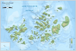
| Map of the Franz Josef Land | ||
| Waters | Arctic Ocean | |
| Archipelago | Franz Josef Land | |
| Geographical location | 80 ° 19 ′ N , 57 ° 55 ′ E | |
|
|
||
| surface | 1 049 km² | |
| Highest elevation | Moscow ice cap 502 m |
|
| Residents | uninhabited | |
| Hall Island location | ||
The Hall Island ( Russian Остров Галля , Ostrow Gallja ) is an island in the south of to Russia belonging to Franz-Josef-Lands in the Arctic Ocean . The island is named after the American polar explorer Charles Francis Hall .
geography
With an area of around 1049 km², Hall Island is the fifth largest island in the archipelago. Its highest point with 502 m is in the southwest of the island near the coast. Large parts of the island are covered by ice all year round. Two prominent headlands lie on the island's south coast, which is ice-free in summer: Cape Tegetthoff and Cape Frankfurt on the eastern tip .
With the retreat of the Sonnklar Glacier over the last few decades, the Littrow Peninsula in the southeast has become the 65 km² Littrow Island, which is separated from Hall Island by the Nordenskjöld Strait.
history
The island was officially discovered on August 30, 1873 as the first island in the archipelago by the Austro-Hungarian North Pole Expedition under the direction of Julius Payer and Carl Weyprecht . During his second attempt to reach the North Pole, the American Walter Wellman set up his base camp at Cape Tegetthoff in 1898. The cape is named after Weyprecht's expedition ship Admiral Tegetthoff , which in turn was named in honor of Wilhelm von Tegetthoff , an admiral of the Austro-Hungarian navy .
Individual evidence
- ↑ UNEP Islands (English)
- ^ Robert Kostka, Aleksey Sharov: Operational Image-Based Mapping in the Franz Josef Land Archipelago (PDF; 1.81 MB). In: International Archives of Photogrammetry and Remote Sensing 31, Part B4, 1996, pp. 469-475.
- ↑ Map (PDF; 13.23 MB) of the southeast Hall Island with the retreat of the ice bridge to Littrow Island from 1953 to 2014 (1.70: 000).


