McClintock Island
| McClintock Island Ostrov Mak-Klintoka (Остров Мак-Клинтока) |
||
|---|---|---|
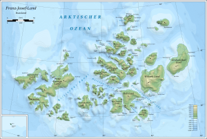
| Map of the Franz Josef Land | ||
| Waters | Arctic Ocean | |
| Archipelago | Franz Josef Land | |
| Geographical location | 80 ° 9 ′ N , 56 ° 29 ′ E | |
|
|
||
| length | 31 km | |
| width | 25 km | |
| surface | 612 km² | |
| Highest elevation | 521 m | |
| Residents | uninhabited | |
The McClintock Island ( Russian Остров Мак-Клинтока ; Ostrow Mak-Klintoka ) is an uninhabited island in the arctic Franz Josef Land, which belongs to Russia .
geography
With an area of 612 km², the island is the seventh largest in the archipelago. It is roughly rectangular in shape, with a maximum length of about 31 kilometers and a width of about 25 kilometers. The McClintock Island is largely glaciated , the highest point being 521 m above sea level. The northernmost point of the island is Cape Greely (мыс Грили; Mys Grili), the south-easternmost the Cape Oppolzer (мыс Оппольцера; Mys Oppolzera).
history
McClintock Island was discovered in 1874 as part of the Austro-Hungarian North Pole Expedition led by Carl Weyprecht and Julius von Payer . It is named after the Irish Arctic explorer Francis Leopold McClintock .
Adjacent islands
- The Alger Island (остров Алджер; Ostrow Aldscher) is about three kilometers north of the McClintock Island. The base camp of the failed Baldwin-Ziegler polar expedition of 1901/02 was on it.
- The Brady Island (остров Брейди; ostrow Brejdi) Six kilometers north-west of McClintock Island. It was named after the English paleontologist , pharmacist and geologist Henry Bowman Brady . The northernmost point of Brady Island, Cape Meadow (мыс Визе; Mys Wise), bears the name of the Russian polar explorer Vladimir Juljewitsch Wiese .
- Only a narrow strait (пролив Негри; Proliw Negri) separates the east bank of McClintock Island from Hall Island (остров Галля; Ostrow Gallja).
- Directly off the south coast is a group of islets called the Borisjak Islands (острова Борисяка; Ostrowa Borisjaka), which are named after the Russian paleontologist Aleksei Aleksejewitsch Borisjak (1872-1944).
- Aagaard Island (Остров Огорд; Ostrow Ogord) is five kilometers off the south coast of McClintock Island . It was named after Andreas Zacharias Aagaard (1847-1925), a Norwegian merchant and consul of Austria-Hungary in Tromsø at the time of the Austro-Hungarian North Pole Expedition.
See also
Individual evidence
- ↑ United Nations Environment Program , accessed February 8, 2016.
- ^ Arthur Montefiore: A Note on the Geography of Franz Josef Land. In: The Geographical Journal. 3, No. 6, 1894, pp. 492-497.
- ↑ Information on McClintock Island at www.franz-josef-land.info, accessed on February 8, 2016.


