Hatuquessi
| Hatuquessi | ||

|
||
| Data | ||
| surface | 10.44 km² | |
| population | 2,899 (2015) | |
| Chefe de Suco | Augosto Vidigal (election 2009) |
|
| Aldeias | Population (2015) | |
| Caicoletohoho | 198 | |
| Caidico | 355 | |
| Hatarlema | 643 | |
| Hatuquessilete | 15th | |
| Lebusalara | 354 | |
| Nunubrihati | 276 | |
| Nunuhou | 250 | |
| Tautalo | 808 | |
|
|
||
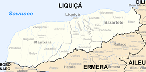
Hatuquessi ( Hatukesi ) is an East Timorese Suco in the administrative office of Liquiçá ( Liquiçá municipality ).
geography
| Hatuquessi | ||
| places | position | height |
| Caicoletohoho | 8 ° 39 ′ S , 125 ° 19 ′ E | 928 m |
| Caidico | 8 ° 39 ′ S , 125 ° 19 ′ E | 811 m |
| Hatarlema | 8 ° 38 ′ S , 125 ° 19 ′ E | 673 m |
| Hataulete | 8 ° 38 ′ S , 125 ° 19 ′ E | ? |
| Hatuquessilete | 8 ° 39 ′ S , 125 ° 19 ′ E | 863 m |
| Lebusalara | 8 ° 39 ′ S , 125 ° 20 ′ E | 1058 m |
| Nunubrihati | 8 ° 39 ′ S , 125 ° 19 ′ E | 978 m |
| Nunuhou | 8 ° 38 ′ S , 125 ° 18 ′ E | 531 m |
| Tautalo | 8 ° 38 ′ S , 125 ° 19 ′ E | 752 m |
Before the 2015 regional reform, Hatuquessi had an area of 10.78 km². Now it is 10.44 km². The Suco is located in the northwest of the Liquiçá administrative office. To the north and southeast is the Suco Dato , northeast of the Suco Loidahar and south of the Suco Leotala . To the west, Hatuquessi borders the Maubara administrative office with its Suco Vatuvou . On the eastern border of the river rises Ricameta which follows the border to the north, and joins there with the springing in Hatuquessi Nomoro to Laklo who continue then north flows. In the south, in the border area to Vatuvou, the Manobira flows south to the Lóis .
In the northwest are the villages of Hataulete , Nunuhou and Tautalo , in the northeast Hatarlema , in the center Caidico ( Caidicu ), Hatuquessilete ( Hatuquesi Lete , Hatuqesi Lete ), Nunubrihati ( Nunubrihate ) and Caicoletohoho and in the southeast Lebusalara ( Lebosalara ). There are primary schools in Nunuhou and Hatuquessilete ( Escola Primaria Hatuquessi ), and in Hatuquessilete there is also a medical station. There are no major roads connecting the Suco with the outside world, which is why the ballot boxes for the parliamentary elections in East Timor in 2007 had to be brought to the polling station in the primary school by horses and porters and then picked up again.
In the Suco there are the eight Aldeias Caicoletohoho , Caidico , Hatarlema , Hatuquessilete , Lebusalara , Nunubrihati , Nunuhou and Tautalo .
Residents
The Suco has 2,899 inhabitants (2015), 1,480 of whom are men and 1,419 women. The population density is 277.6 inhabitants / km². There are 506 households in the Suco. Almost 94% of the population give Tokodede as their mother tongue. Over 5% speak Tetum Prasa and a minority speak Tetum Terik .
history
At the end of 1979 there was a so-called transit camp in Hatarlema , in which the Indonesian occupiers interned East Timorese civilians.
politics
In the 2004/2005 elections , Alberto Rodrigues was elected Chefe de Suco. In the 2009 elections Augosto Vidigal won .
Web links
- Results of the 2010 census for the Suco Hatuquessi ( tetum ; PDF; 8.2 MB)
- Results of the 2015 census for the Suco Hatuquessi (tetum; PDF)
- Seeds of Life: Suco information sheets Liquiçá (tetum)
Individual evidence
- ↑ a b c d Direcção-Geral de Estatística : Results of the 2015 census , accessed on November 23, 2016.
- ↑ Fallingrain.com: Directory of Cities, Towns, and Regions in East Timor
- ↑ Direcção Nacional de Estatística: Population Distribution by Administrative Areas Volume 2 English ( Memento from January 5, 2017 in the Internet Archive ) (Census 2010; PDF; 22.6 MB)
- ^ Timor-Leste GIS-Portal ( Memento from June 30, 2007 in the Internet Archive )
- ↑ a b List of polling stations for the parliamentary elections in East Timor 2007 (PDF file; 118 kB)
- ↑ UNMIT: Timor-Leste District Atlas version 02, August 2008 ( Memento of December 3, 2011 in the Internet Archive ) (PDF; 486 kB)
- ↑ Jornal da Républica with the Diploma Ministerial n. 199/09 ( Memento of February 3, 2010 in the Internet Archive ) (Portuguese; PDF; 323 kB)
- ↑ Results of the 2010 census for the Suco Hatuquessi ( tetum ; PDF; 8.2 MB)
- ↑ "Chapter 7.3 Forced Displacement and Famine" ( Memento of November 28, 2015 in the Internet Archive ) (PDF; 1.3 MB) from the "Chega!" Report of the CAVR (English)
- ↑ Secretariado Técnico de Administração Eleitoral STAE: Eleições para Liderança Comunitária 2004/2005 - Resultados ( Memento of August 4, 2010 in the Internet Archive )
- ↑ Secretariado Técnico de Administração Eleitoral STAE: Eleições para Liderança Comunitária 2009 - Resultados ( Memento of August 4, 2010 in the Internet Archive )
