
Sky city
| coat of arms | Germany map | |
|---|---|---|

|
Coordinates: 49 ° 55 ' N , 9 ° 48' E |
|
| Basic data | ||
| State : | Bavaria | |
| Administrative region : | Lower Franconia | |
| County : | Main-Spessart | |
| Management Community : | Zellingen | |
| Height : | 165 m above sea level NHN | |
| Area : | 13.42 km 2 | |
| Residents: | 1562 (Dec. 31, 2019) | |
| Population density : | 116 inhabitants per km 2 | |
| Postal code : | 97267 | |
| Area code : | 09364 | |
| License plate : | MSP | |
| Community key : | 09 6 77 142 | |
| Community structure: | 1 district | |
| Association administration address: | Würzburger Str. 26 97225 Zellingen |
|
| Website : | ||
| Mayor : | Herbert Hemmelmann ( CSU ) | |
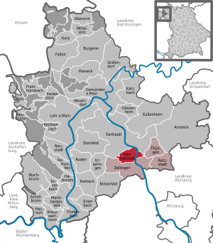
| Location of the community of Himmelstadt in the Main-Spessart district | ||
  |
||


Himmelstadt is a municipality in the Lower Franconian district of Main-Spessart . The place of the same name is both the capital and the seat of the municipal administration.
Due to the “heavenly” name of the community, the Himmelstadt Christmas post office has existed since 1986 and is operated jointly by Deutsche Post and the community.
geography
location
Himmelstadt lies on the banks of the Main , at the Maindreieck in the area of the Mainfränkische Platten . The district of Himmelstadt is the only one in the district that extends on both sides of the Main. To the left of the Main is the extensive Himmelstadt Forest, to the right of the Main are the Himmelstadt vineyards .
The district has an area of 1341 hectares. Of this, 12.2% are settlement and traffic areas, 37.3% are used for agriculture and 43.7% (586 hectares) are forest.
geology

Before about 240 million years ago covered the by Spessart and Odenwald pent Triassic sea Main Franken until the Main gradually its valley in the form of the main quadrangle burying as a drain of the sea. The last traces of the sea date from around 180 million years ago. In the intervening 60 million years, it deposited shell limestone , which in the form of high rock faces characterizes the landscape around Himmelstadt. The Main flows through the municipality in an almost northerly direction, before the steep slope of the Stettener Berg forces it to the northwest to Laudenbach. While the steep slopes dominate the right bank of the river, gentle embankments emerged on the left, which run into a thick layer of Main sand , gravel and loess or loess loam towards the Main.
Neighboring communities
| District town Karlstadt |
||
.svg)
|
Thüngen market |
|
| Zellingen market |
climate
In Himmelstadt a climate that prevails in continentality in the transition zone between maritime climate and continental climate is. The region is characterized by hot, dry summers and cold winters, with Himmelstadt often remaining free of snow due to its location on the Main.
Investigations by the Veitshöchheim State Institute provided the following climate data for the region:
- Frost-free growing season: 160 - 190 days
- Duration of sunshine: 1600 to 1750 hours
- Annual temperature: 8.5 - 9.0 ° C (with increasing trend)
- Rainfall: 500 - 600 l / m²
The next weather station is in Arnstein-Müdesheim.
history
etymology
The original name consists of the personal name of the town's founder Immina and the Old High German word stat . In the 13th century, the first name was reinterpreted in Middle High German himel , which can also be seen in the Latin suffix Celiporta (gate of heaven).
Earlier spellings
Earlier spellings of the place from various historical maps and documents:
|
|
As finds from the Bandkeramik , Hallstatt and Latène periods show, the area of Himmelstadt was already settled in the Neolithic
At the time of the Merovingians , the settlement was owned by the Franconian Duke Hetan II . His daughter Immina, who was born around 700 and who inherited the inheritance after his death and that of her brother, lived a monastic way of life. King Pippin gave her several goods for the time of her life, while the rest of the duchy passed to the diocese of Würzburg . Historians do not yet have a unified opinion about the exact course of the donation and the goods concerned.

In 753, after the death of the town's founder, Immina, the property passed back to Bishop Burkard von Würzburg, whose name can also be found in the former Burkardstuhl court stables.
In 820 the place was first mentioned as a "Himminestat" in a deed of donation to the Fulda monastery.
In 840 the place changed hands again and was given to Count Bernhart of Franconia by Emperor Ludwig the Pious .
In 1231 the Cistercian monastery Himmelspforten in Himmelstadt was founded by Bishop Hermann I of Lobdeburg . Due to ongoing disputes and looting by a knight Herold von Zellingen, it was moved from Himmelstadt to Himmelspforten near Würzburg in 1253.
1291 was the first written mention of the vineyards in Himmelstadt.
The plague raged in 1611 and claimed 189 lives in 12 months (47% of the population).
In 1614 the St. Jakobus Church was consecrated in the presence of Julius Echter .
During the 30 Years War , Himmelstadt was often plundered and destroyed by troops passing through.
In 1795 a high altar was purchased.
In 1803 the economic assets of the monastery, which belonged to the Franconian Empire , were secularized in favor of Bavaria.
In the Peace of Pressburg in 1805, the district was given to Archduke Ferdinand of Tuscany to form the Grand Duchy of Würzburg.
In the course of the administrative reforms in Bavaria, today's municipality was created in 1818 with the municipal edict of 1818 .
In 1899 the railway station (fifth class) was built.
In 1907 the steel Main Bridge was opened to better connect the train station and the vineyards to the place.
In 1924 the first residential buildings were built on the right side of the Main. By 1951 there were already 31 residential buildings in the "settlement".
In 1926 around 7,000 pilgrims came to the place after an apparition of Mary .
From 1934 to 1940 the barrage and the lock were expanded.
On March 28, 1945, the bridge was blown up on the orders of the German Wehrmacht leadership; by 1949 it was rebuilt.
In 1954 the gym of TSV Himmelstadt was inaugurated.
In 1965 the St. Immina Memorial Church was built to accommodate the rapidly growing community; the St. James Church was closed.
1973 the new town hall was inaugurated.
In 1978 the administrative association Zellingen (with Zellingen , Retzbach , Duttenbrunn , Retzstadt and Thüngen ) was founded.
In 1981 the bridge was replaced by a modern prestressed concrete bridge.
The multi-purpose hall was inaugurated in 1982 , the gymnasium was demolished the year before.
In 1984 the underpass under the Würzburg – Gemünden railway was completed.
In 1989 the business park on the B 27 was decided.
The vineyard chapel Maria an der Kelter was inaugurated in 1994 and the new primary school in 1997 .
In 2000, the St. Jakobus Church was rededicated after a lengthy restoration under the direction of the Friends' Association for the Preservation of the Julius Echter Church.
In 2010 the St. Immina Memorial Church was profaned and demolished.
In 2012 the new parish center Sel. Immina built on the foundations of the former St. Immina Memorial Church.
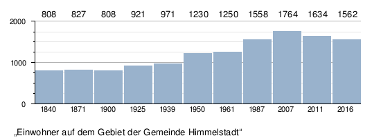
Population development
In the period from 1988 to 2018, the population decreased from 1598 to 1581 by 17 or 1.1%.
politics
The community is a member of the Zellingen administrative community
Municipal council
| Party / list | Share 2014 | Seats 2014 | Share 2020 | Seats 2020 |
| CSU / FBL | 36.52% | 5 | 40.49% | 5 |
| SPD | 27.50% | 3 | 31.46% | 4th |
| New list sky city | 35.98% | 4th | 28.04% | 3 |
Status: 2020
mayor
Herbert Hemmelmann (CSU) was elected mayor on November 19, 2018. The term of office will last until 2026. The predecessor was Gundram Gehrsitz (CSU / Freie Bürgerliste), who died in office on July 12, 2018. In 2016, the former mayor Harald Führer (CSU / Freie Bürgerliste) was awarded the title of “ former mayor ”.
coat of arms
|
|
Blazon : “A blue wave bar in silver; above a three-part, red rose branch , below the red monogram HP. "
The place came to the Würzburg Cathedral in 840 and remained under the rule of the Würzburg Monastery until the end of the Old Kingdom in 1803 . The colors silver and red are a reminder of this long-standing affiliation. The monogram HP is the district mark of the Cistercian monastery Himmelspforten, which was founded in 1231 by Prince Bishop Hermann von Lobdeburg (1225 to 1254) in the municipality of Himmelstadt and was still under his government in 1250 near Würzburg was relocated. This monogram has been handed down on old boundary stones that marked former monastery property. The rose branch is taken from the convent seal of the monastery and, as a Marian motif, indicates the Cistercian convent. The blue wave bar symbolizes the geographic location of the municipality on both sides of the Main. |
Culture and sights
Architectural monuments
According to the current monument protection list, there are 18 protected architectural monuments and eleven protected wayside shrines in the town center.
Soil monuments
In 2018 geophysical soil surveys were carried out in order to determine the condition, location and location of the former Himmelspforten monastery and the Burkardstuhl castle stalls. The investigations are still ongoing.
In the district of Himmelstadt there are several settlements and sites of the band ceramics , Hallstatt and Latène times , in the Himmelstadt forest there are individual burial mounds of prehistoric times.
Churches
- St. James
- The Julius Echter Church of St. Jakobus, built in 1613, was renovated under the direction of the Friends' Association from 1990 and re-inaugurated in 2000. With the profanation of the St. Immina Memorial Church in 2010, St. Jakobus became the parish church of Himmelstadt again.
- St. Immina Memorial Church
- The St. Immina Memorial Church, built in 1965 as a modern concrete building, was deconstructed and demolished in 2010 as it was in need of renovation. A modern community center was built on its foundations and inaugurated in 2010. A small Marienkapelle reminds of the former church.
- Vineyard chapel Maria an der Kelter
- In 1994 established the vineyard Chapel of Mary at the wine press, the cast of a is rococo - House figure that Maria as Duchess is of francs. Every year on Whit Monday there is a field service there.
Historic lime kiln
In 2017, a lime kiln from the 19th century was restored by the Tourism Working Group and equipped with benches and display boards.
Biking and hiking trails
There are 7 marked hiking trails in the Himmelstadt district, some of which are located in the forest and in the vineyards. Parts of it lead along the Franconian Marienweg. Along the Main there is a towpath that leads from Karlstadt via Himmelstadt to Retzbach .
The MainRadweg , which is over 500 kilometers long, runs along the Main .
Economy and Infrastructure
Established businesses
According to official statistics, there were 74 in the manufacturing sector in 2011, 67 in the trade and transport sector, 11 in the corporate service provider sector and 11 in public and private service providers at the place of work. There were a total of 665 employees at the place of residence subject to social security contributions. There was one company in the manufacturing sector and two companies in the construction sector. In addition, there were 12 farms in 2011.
The unemployment rate was 2 percent in 2016.
traffic
The federal road 27 leads east past Himmelstadt. State road 2300 (from Mühlbach to Würzburg) leads through Himmelstadt to the left of the Main.
To the right of the Main, Himmelstadt has a train station on the Main-Spessart-Bahn ( Würzburg - Hanau ), which is served every hour by the regional train. The high-speed line Hanover – Würzburg with several short tunnel sections leads through the Himmelstadter Forest .
Since 2003, a motorway-like federal trunk road has been planned with the federal highway 26n , which will span the main valley with a bridge north of Himmelstadt. In the Federal Transport Infrastructure Plan 2030 , however, only the expansion of the section to Karlstadt is planned.
Water and energy
- The community of Himmelstadt supplies itself with drinking water from its own Feldmühl spring .
- A hydropower plant with 2.60 megawatts is located at the Himmelstadt barrage.
education
The following institutions exist (as of 2017):
- Kindergarten Zwergenhöhle: 75 kindergarten places with 40 children
- An elementary school with three full-time teachers and 44 students
Culture
Regular events
- State meetings and Carnival Monday parade
- May celebration
- Bruges Festival
- summer party
- Thanksgiving
- Several local wine houses , fishermen's huts and hedge taverns hold festivals throughout the year.
- As part of the Himmelstadt invites program , there are events throughout the year, such as vineyard hikes or historical village tours.
Himmelstadter Christmas experiences and Christmas post office
Because of the name Heaven 1,928 letters have already been to the -Stadt Christkind sent answered in Himmelstadt. Himmelstadt has been the official Christmas post office since 1986, where several volunteers answer letters from all over the world. Letters that are thrown into a post box at the historic post office receive a special Deutsche Post postmark .
On the 1st and 3rd Advent there is a regionally known Christmas market with around 50 dealers, craftsmen and exhibitors. Letters to the Christ Child can be handed in directly to the " Engelchen " in the town hall on these dates .
Club life
There are currently 19 clubs registered in Himmelstadt , including the carnival club, the volunteer fire brigade, three music clubs, several sports clubs, as well as several political associations and interest groups. The model flying club operates a model airfield on the edge of the forest .
Museums and parks
Historic post office
The Christmas Post Office exhibition is open all year round from 9:00 a.m. to 6:00 p.m. in the historic post office on the bridge.
First German philatelic educational trail
The first German philatelic educational trail is located on the banks of the Main . With more than 30 display boards, it provides information about the Christmas and flower stamps of the respective year, as well as about special stamps for important anniversaries in the history of the Federal Republic of Germany.
Ecological wine trail
An ecological wine trail with selected table grapes was also set up on the banks of the Main, providing information on 11 grape varieties and tasting them at harvest time.
NaturSchauGarten Main-Spessart
The 800 m² show garden was opened in 2017 as a teaching and demonstration object for a garden culture that is predominantly characterized by local plants and materials.
Lookout points in the vineyards

There are three larger viewpoints along the hiking trails in the Himmelstatter and Stetten vineyards:
- Vineyard pavilion on the Lerchenberg
- Refuge on the Stettener Stein
- Terroir-f point "Magical place of Franconian wine" [2]
Personalities
- Johann Adam Brandenstein (1657–1726), organ builder, father of Johann Konrad Brandenstein
- Stefan Schmid (born May 6, 1970) athlete (decathlete)
Web links
Individual evidence
- ↑ "Data 2" sheet, Statistical Report A1200C 202041 Population of the municipalities, districts and administrative districts 1st quarter 2020 (population based on the 2011 census) ( help ).
- ↑ Mayor & City Council. Himmelstadt municipality, accessed on August 17, 2020 .
- ↑ www.statistik.bayern.d. (PDF) Retrieved June 15, 2018 .
- ↑ Der Spiegel, online edition of July 6, 2015: Summer in Germany: Kitzingen sets a new heat record
- ↑ Fighting late frost in vineyards. (PDF) Retrieved May 24, 2018 .
- ↑ [1]
- ↑ a b Wolf-Armin von Reitzenstein : Lexicon of Franconian place names. Origin and meaning . Upper Franconia, Middle Franconia, Lower Franconia. CH Beck, Munich 2009, ISBN 978-3-406-59131-0 , p. 104 ( limited preview in Google Book search).
- ↑ Bavarian Monument Atlas. Retrieved June 14, 2018 .
- ^ Franconia Sancta - The life of the saints and blessed of Franconia - JB Stamminger 1881
- ↑ Notes from Magister Lorenz Fries in the Würzburg Chronicle
- ↑ Monumenta Boica XXVIII, 35
- ↑ Document regests on the history of the Cistercian monastery Himmelspforten, Hermann Hoffmann, 1962
- ^ "Neu-Himmelstadt on the right side of the Main" - Main-Post 09/21/1951
- ↑ Chronicle. Retrieved June 15, 2018 .
- ^ Municipality of Himmelstadt, municipal council election 2020 - overall result
- ↑ GR-Himmelstadt 2014. Retrieved on June 15, 2018 .
- ↑ 2020 municipal council election , accessed on June 29, 2020
- ^ New mayor in Himmelstadt. Retrieved November 21, 2018 .
- ↑ Mayor of Himmelstadt succumbs to a heart attack In: BR.de ( Bayerischer Rundfunk ), July 14, 2018. Retrieved on September 4, 2019.
- ↑ Harald Führer is a former mayor . In: MainPost.de , January 8, 2016.
- ^ Entry on the coat of arms of Himmelstadt in the database of the House of Bavarian History
- ^ House of Bavarian History - Bavaria's municipalities. Retrieved June 15, 2018 .
- ↑ Himmelstadt is rich in historical buildings. Retrieved July 11, 2013 .
- ↑ Bavarian Monument Atlas. Retrieved June 14, 2018 .
- ↑ Historical lime kiln. Retrieved June 14, 2018 .
- ↑ Biking and hiking trails. Retrieved June 15, 2018 .
- ↑ www.statistik.bayern.de. (PDF) Retrieved June 12, 2018 .
- ↑ Planning status at the Würzburg State Building Authority ( Memento from February 18, 2015 in the Internet Archive )
- ↑ http://www.wsa-schweinfurt.wsv.de/. Retrieved June 12, 2018 .
- ↑ Himmelstadt Christmas Experiences. Retrieved June 15, 2018 .
- ↑ Club life. Retrieved June 12, 2018 .
- ↑ club - FMSC Milan eV Accessed on 15 June 2018 .
- ↑ NaturSchauGarten Main-Spessart. Retrieved June 12, 2018 .

Arnstein | Aura in the reason | Birkenfeld | Bischbrunn | Burgsinn | Erlenbach near Marktheidenfeld | Esselbach | Eußenheim | Skins | Frammersbach | Gemünden am Main | Gössenheim | Graefendorf | Hafenlohr | Hasloch | Sky city | Karbach | Karlstadt | Karsbach | Kreuzwertheim | Lohr am Main | Marktheidenfeld | Middle sense | Neuendorf | Neuhütten | Neustadt am Main | Obersinn | Partenstein | Rechtenbach | Retzstadt | Rieneck | Clearing | Rothenfels | Schollbrunn | Steinfeld | Thüngen | Triefenstein | Urspringen | Wiesthal | Zellingen
Municipality-free areas in the district of Main-Spessart
Burgjoss |
Forest aura |
Forest Lohrerstraße |
Frammersbach Forest |
Princely Löwensteinscher Park |
Haurain |
Herrnwald |
Langenprozeltener forest |
Partenstein Forest |
Ruppertshütten forest