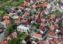
Steinfeld (Lower Franconia)
| coat of arms | Germany map | |
|---|---|---|

|
Coordinates: 49 ° 57 ' N , 9 ° 40' E |
|
| Basic data | ||
| State : | Bavaria | |
| Administrative region : | Lower Franconia | |
| County : | Main-Spessart | |
| Management Community : | Lohr am Main | |
| Height : | 277 m above sea level NHN | |
| Area : | 33.69 km 2 | |
| Residents: | 2117 (Dec. 31, 2019) | |
| Population density : | 63 inhabitants per km 2 | |
| Postal code : | 97854 | |
| Area code : | 09359 | |
| License plate : | MSP | |
| Community key : | 09 6 77 186 | |
| Community structure: | 3 districts | |
| Address of the municipal administration: |
Rathausstrasse 16 97854 Steinfeld |
|
| Website : | ||
| Mayor : | Günter Koser | |
| Location of the municipality of Steinfeld in the Main-Spessart district | ||
Steinfeld is a municipality in the Lower Franconian district of Main-Spessart and a member of the Lohr am Main administrative community . The districts of Hausen and Waldzell belong to the municipality. A Main Franconian dialect is spoken (according to the language atlas of the Bavarian State Library: Lower East Franconian). The locals in the area are often referred to by the local name Steefld'r Russe .
geography
Geographical location
Steinfeld lies between Lohr am Main and Karlstadt on the Franconian plate (Marktheidenfelder Platte) at the sources of the Buchenbach . Here there is a transition between red sandstone and Franconian shell limestone . The greater part of the municipality is still used for agriculture today; In addition, the municipality cultivates significant forests in the so-called Würzburger Spessart (extreme eastern foothills of the low mountain range). The majority of employees commute to the surrounding cities of Lohr and Karlstadt as well as to Würzburg .
Community structure
Steinfeld is divided into three districts:
There are the districts : Hausen, Steinfeld and Waldzell.
history
Until the church is planted
As grave mounds on the Kohlplatte show, the municipality was already settled in the Bronze Age. Steinfeld was first mentioned in a document in 812; in documents from that time it is referred to as Steinvelt in Waldsassengove (i.e. Waldsassengau ). During the time of the tribal duchies , the place was in the Duchy of Franconia . By 1200 Steinfeld was already an independent parish; the Neustadt am Main monastery raised claims to tithe. Around 1336 the parish church was integrated into the Nuwenstat monastery (New Town). In 1614, the new building of the parish church of the Assumption was completed by Prince-Bishop Julius Echter . Clear indications of this are u. a. the building board on the south side of the nave and the tower in the typical real style . In 1842 the nave was extended. As part of the Hochstift Würzburg (Rothenfels Office), Steinfeld came to the Counts of Löwenstein-Wertheim in the Reichsdeputationshauptschluss 1803. From 1500 both belonged to the Franconian Empire . In 1806 it became a Baden media office, which was ceded to Austria in 1819, which left it to Bavaria. According to the parish edict of 1818, today's parish was established there.
![]()
Districts
The two districts of Hausen (since 1972) and Waldzell (since 1978) belong to the community today. The district of Hausen was first mentioned in a document around 800. Since 1192 Hausen was a branch church of the parish Wiesenfeld . The farmer's guide Kaspar Leyser comes from Hausen . He was beheaded in June 1525 together with two other rebel farmers in Karlstadt. In 1817 the church of St. Cyriakus (probably above a previously existing chapel) was completed, and in 1879 the church tower was raised. The district of Waldzell (formerly: Cella / Zell ) was probably also created in the 9th century as a branch of the Neustadt monastery. There are historical references to St. Gertraud . The Gertraudenkapelle there was built over a spring with the same name (1616 by Julius Echter , extension around 1849). Today's St. Vitus Church was built in 1612 by order of Julius Echter. Parts of the former monastery (built in 1707) are still preserved.
Incorporations
On July 1, 1972, the previously independent community of Hausen was incorporated. Waldzell was added on May 1, 1978.
Population development
In the period from 1988 to 2018, the population increased minimally from 2097 to 2120 by 23 inhabitants or 1.1%.
- 1961: 1855 inhabitants
- 1970: 1991 inhabitants
- 1987: 2060 inhabitants
- 1991: 2195 inhabitants
- 1995: 2278 inhabitants
- 2000: 2277 inhabitants
- 2005: 2296 inhabitants
- 2010: 2184 inhabitants
- 2011: 2212 inhabitants
- 2012: 2195 inhabitants
- 2013: 2191 inhabitants
- 2014: 2184 inhabitants
- 2015: 2187 inhabitants
- 2016: 2154 inhabitants
politics
mayor
Günter Koser has been the mayor since May 1, 2014 (supported by the CSU / Bürgerblock as well as by the Hausen Voting Association and the Waldzell Free Voting Group); he was re-elected on March 15, 2020 with 95.0% of the vote.
Municipal council
The 2020 results in the following distribution of votes and seats in the municipal council election:
| Share of votes | Seats | |
|---|---|---|
| CSU / Citizens' Block | 23.80% | 3 |
| Free voters Steinfeld village community | 30.63% | 4th |
| Voter community Hausen | 25.45% | 4th |
| Waldzell Free Voting Group | 20.12% | 3 |
coat of arms
The description of the municipal coat of arms, introduced in 1982, reads: “In green from a silver shield, in it the uncial capital letter N exaggerated with a black cross, growing silver nimbly Saint Sebastian, who holds two upside down diagonally crossed silver arrows in his right hand, removed top right from a red shield with three lowered silver tips, top left of a gold shield with red diagonal bars “.
Town twinning
Since 1992 there has been a partnership with the French community of Chauvigné ( Brittany ), which is maintained through visits (every two years) and through which close Franco-German friendships have already developed.
Culture and sights
- Shared laundry room of 1889 under the church plateau (of the road visible)
Architectural monuments
Economy and Infrastructure
Economy including agriculture and forestry
According to official statistics, there were 192 employees at the place of work in the manufacturing sector and 52 in the trade and transport sector. There were a total of 879 employees at the place of residence subject to social security contributions. There were three companies in the manufacturing sector and three in the construction sector. In addition, in 1999 there were 77 farms with an agriculturally used area of 1887 ha, of which 1666 ha were arable land and 206 ha were permanent green space. The community owns 1230 hectares of community forest, which is managed by its own forest enterprise.
education
The following institutions exist (as of: 1999):
- Kindergartens: 100 kindergarten places with 93 children
- Elementary schools: one with seven teachers and 124 students
literature
- Karl Josef Barthels: Steinfeld near Lohr am Main: Contributions to a chronicle. C. Keller, Lohr am Main 1956–1959, issues 1–3
- Karl Josef Barthels: Small Chronicle of Mariabuchen. C. Keller, Lohr am Main 1954 (including extensive references to the history of the Steinfeld parish)
- Josef Schott: The district of Lohr and its communities. C. Keller, Lohr am Main 1964 (pages 111–119, districts treated individually, contains good references to sources)
Web links
- official homepage
- Entry on the coat of arms of Steinfeld (Lower Franconia) in the database of the House of Bavarian History
- Audio samples of the Steinfeld dialect (interactive map of the Bavarian State Library)
- Steinfeld (Lower Franconia): Official statistics of the LfStat
Individual evidence
- ↑ "Data 2" sheet, Statistical Report A1200C 202041 Population of the municipalities, districts and administrative districts 1st quarter 2020 (population based on the 2011 census) ( help ).
- ↑ http://www.bayerische-landesbibliothek-online.de/orte/ortssuche_action.html ? Anzeige=voll&modus=automat&tempus=+20111119/224332&attr=OBJ&val= 1746
- ↑ Main Post article on the opening of the Archaeological Trail
- ^ Karl Barthels, Volume I. Page 18 f., On the incorporation in Neustadt
- ^ Karl Barthels, Volume I. Page 73, on the new building of the Steinfeld parish church
- ↑ http://www.hgv-steinfeld.de/ Contributions to local history No. 3 (2011), publication by the Heimat- und Geschichtsverein Steinfeld-Hausen-Waldzell
- ↑ Anniversary Gertraudenfest in Waldzell on mainpost.de
- ^ Karl Barthels, Heft 1, p. 73 and p. 76, on church buildings in Waldzell
- ^ Wilhelm Volkert (ed.): Handbook of Bavarian offices, communities and courts 1799–1980 . CH Beck, Munich 1983, ISBN 3-406-09669-7 , p. 491 .
- ↑ a b c Federal Statistical Office (ed.): Historical municipality directory for the Federal Republic of Germany. Name, border and key number changes in municipalities, counties and administrative districts from May 27, 1970 to December 31, 1982 . W. Kohlhammer GmbH, Stuttgart / Mainz 1983, ISBN 3-17-003263-1 , p. 763 .
- ↑ 2020 municipal council election , accessed on July 3, 2020


