
Karlstadt
| coat of arms | Germany map | |
|---|---|---|

|
Coordinates: 49 ° 58 ' N , 9 ° 46' E |
|
| Basic data | ||
| State : | Bavaria | |
| Administrative region : | Lower Franconia | |
| County : | Main-Spessart | |
| Height : | 163 m above sea level NHN | |
| Area : | 98.18 km 2 | |
| Residents: | 14,983 (Dec. 31, 2019) | |
| Population density : | 153 inhabitants per km 2 | |
| Postal code : | 97753 | |
| Primaries : | 09353, 09359 , 09360 , 09396 | |
| License plate : | MSP | |
| Community key : | 09 6 77 148 | |
| LOCODE : | DE KSD | |
| City structure: | 10 districts | |
City administration address : |
Zum Helfenstein 2 97753 Karlstadt |
|
| Website : | ||
| Mayor : | Michael Hombach ( CSU ) | |
| Location of the city of Karlstadt in the Main-Spessart district | ||
  |
||

Karlstadt is the district town of the Lower Franconian district of Main-Spessart and is located around 30 kilometers north of Würzburg in the Main Franconian wine-growing region .
In the Main Franconian dialect , Karlstadt is called Karscht or Karscht am Mee . The residents are called Flaak or Karschter Flaak.
geography
City structure
Karlstadt consists of the main town and nine other districts, in which twelve towns are distributed:
- Gambach
- Hesslar
- Karlburg
- Karlstadt
- Laudenbach
- Mühlbach
- Rohrbach
- Stadelhofen
- Stetten
- Wiesenfeld with the villages of Erlenbach and Rettersbach
Each district (including Karlstadt) has a district . There is also the Gainfurter Markung.
Neighboring communities
| City of Lohr am Main |
City of Gemünden am Main |
Municipalities of Gössenheim and Eußenheim |
| Municipality Steinfeld |
.svg)
|
City of Arnstein |
| Community of Urspringen |
Market Zellingen and community Himmelstadt |
Thüngen market |
Surname
etymology
The basic word in the name Karlstadt is the Middle High German word stat (city). The name was taken over from the original settlement Karlburg .
Earlier spellings
Earlier spellings of the place from various historical maps and documents:
|
|
history
Before the regional reform in Bavaria
The first mention of Karlburg in 741/42 is directly related to the establishment of the diocese of Würzburg. Around 1202, the settlement of Karlstadt near Karlburg was founded by Bishop Konrad von Querfurt . The exact date of foundation is not known. The earliest evidence of the city seal was made in 1277. The Oberamt Karl city of Hochstift Würzburg was after the secularization left in 1803 in favor of Bavaria in 1805 Archduke Ferdinand of Tuscany to form his Grand Duchy and fell with this 1814 final to Bayern. The district court of Karlstadt (older order) was the forerunner of the district of Karlstadt , which was dissolved in 1972.
Incorporations
On April 1, 1971, the previously independent municipality of Gambach was incorporated. Stetten was added on January 1, 1978. Heßlar, Karlburg, Laudenbach, Mühlbach, Rohrbach, Stadelhofen and Wiesenfeld followed on May 1, 1978.
Population development
In the period from 1988 to 2018, the population increased from 14,669 to 15,004 by 335 inhabitants or 2.3%.
politics
City council
The city council of Karlstadt (excluding the mayor) has 24 members.
| CSU | SPD | GREEN | FWG |
The Left / The PARTY |
total | ||
| 2002 | 10 | 7th | 2 | 5 | - | 24 seats | |
| 2008 | 8th | 6th | 3 | 7th | - | 24 seats | |
| 2014 | 8th | 5 | 5 | 6th | - | 24 seats | |
| 2020 | 8th | 4th | 5 | 6th | 1 | 24 seats |
mayor
Michael Hombach (CSU) has been mayor since May 1, 2020; he was elected in the runoff election on March 29, 2020 with 58.7% of the vote. His predecessor was Paul Kruck (Free Voting Association) from May 2008 to April 2020.
coat of arms
The description of the coat of arms, which goes back to the 13th century, reads: "Square of blue and silver, in 2 and 3: a red heraldic lily".
Twin cities
- Cuckfield ( West Sussex , United Kingdom)
- Mühlbach ( Pustertal , South Tyrol, Italy)
- Querfurt ( Saxony-Anhalt , Germany)
- Saint-Brice-en-Coglès ( Brittany , France)
Architectural monuments
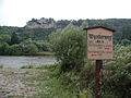
Karlstadt, Karlsburg on the other bank of the Main

Karlstadt, Maintor with high water level

Karlstadt, Maintorturm and Maintor

Catholic parish church of St. Andreas
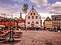
Historic town hall with coat of arms of Prince-Bishop Johann Philipp von Schönborn


Economy and Infrastructure
traffic
- The station Karlstadt (Main) is located on the Main-Spessart Railway (Würzburg-Hanau) and was opened on October 1st. 1854 It is usually served hourly by the regional express on the Würzburg - Frankfurt (Main) line and by regional trains on the Würzburg- Gemünden (Main) - Jossa line.
- The high-speed line Hanover – Würzburg runs through the municipality in a north-south direction. A section of the Mühlberg tunnel and part of the Nantenbacher bend are located on the territory of the municipality .
- Karlstadt is also at the junction of two federal highways , the B 26 and the B 27 . State roads 2435 and 2438 also run through Karlstadt. The next motorways are the BAB 3 with the junction Marktheidenfeld , Rottendorf and Helmstadt , the BAB 7 with the junction Gramschatzer Wald, Autobahnkreuz Schweinfurt / Werneck and Hammelburg and the BAB 70 with the Autobahnkreuz Schweinfurt / Werneck. The river can be crossed on two road bridges, the Main Bridge Karlstadt from 1953 and the Karolinger Bridge to the north .
- The city can also be reached by water via the Karlstadt harbor .
- There is an airfield in Karlstadt , the Karlstadt-Saupurzel glider airfield . This has two long, unpaved runways. General aviation flights often start here .
Industry, craft and trade

The iron works culvert , the cement works Schwenk Karlstadt and the veneer works Kohl determine the south of the city. The Schwenk cement plant obtains the necessary limestone from a quarry on the other side of the Main, which is connected to the plant via a belt conveyor that runs over the Main via a suspension bridge . In addition to these three large industrial companies, numerous craft businesses are also located in Karlstadt. Another major employer is the Main-Spessart District Office. Most residents, however, commute to Würzburg, 25 kilometers away, or Lohr am Main, approx. 18 km away .
media
The "Langer Karl" transmission tower east of the city serves to broadcast Radio Charivari on 88.6 MHz with 50 watt ERP.
tourism
Especially in the summer months, the old town is a popular destination for cycle tourists who come to Karlstadt via the Werntal cycle path as well as the Maintal cycle path. The Franconian Marienweg also runs through Karlstadt . There are three hotels, several guest houses and a campsite on the banks of the Main that offer overnight accommodation.
Events
Since 1996 there has been a "Free & Draussen" festival in July at Saupurzel, which is combined with a foam party .
Viticulture
Viticulture is only of minor economic importance, but of great cultural importance . Even if very few people in Karlstadt still make a living from viticulture, it is still important for self-perception and the local way of life. Karlstadter locations are the Roßtal ( large location ) and Im Stein single location . There are also other locations in numerous districts , especially in Stetten (Stettener Stein) and also at the transition from Karlstadt to Gambach.
nature
education
The following institutions exist (as of: 1999):
- Kindergartens: 549 kindergarten places with 548 children
- Primary schools: five with 63 teachers and 1,147 students
- Konrad von Querfurt Middle School
- Johann-Schöner-Gymnasium : approx. 80 teachers and 1119 students (as of 2010)
- Johann-Rudolph-Glauber-Realschule : 613 students (as of 2012)
- State vocational school Main-Spessart
- special school
- Municipal singing and music school: 18 teachers and 499 students (as of the 2012/2013 school year)
- “Piranha” youth culture center with around 10,000 visitors a year
Since July 7, 2007, all four schools in Karlstadt have had the title " School without Racism - School with Courage ".
Sports
Three associations are active in Karlstadt. TSV Karlstadt offers basketball, handball, volleyball, tennis, athletics and swimming. Football is offered by FV 1920 Karlstadt. For a few years now, FV Fatihspor Karlstadt has also been offering football. The most successful football club, however, is TSV Karlburg from the district of the same name , which plays in the Bavarian League.
Personalities
- Johann Schöner (born January 16, 1477; † January 16, 1547 in Nuremberg ), mathematician, geographer, cartographer, astronomer and astrologer
- Andreas Bodenstein (also called Karlstadt or in Latinized form Carolstadius after his place of birth , * around 1482; † December 24, 1541 in Basel ), reformer
- Johann Draconites (actually Johann Drach, * around 1494; † April 18, 1566 in Wittenberg ), theologian, humanist philosopher and reformer
- Michael Beuther (born October 18, 1522, † October 27, 1587 in Strasbourg ), historian, poet, lawyer and civil servant
- Johann Rudolph Glauber (March 10, 1604 - March 16, 1670 in Amsterdam ), pharmacist and chemist
- Johann Baal (also Pater Marianus Baal, born December 18, 1657, † 1701), organist, conductor and composer
- Sebald Brendel (born September 8, 1780, † December 21, 1844 in Würzburg), lawyer and professor at the University of Würzburg
- Philipp Schech (born December 25, 1845; † July 2, 1905 in Munich), laryngologist in Munich
- Franz Werthmann (born October 13, 1845 or 1846 in Wiesenfeld , † April 23, 1920 in Wiesenfeld), Mayor Wiesenfeld, member of the Reichstag and Landtag
- Georg Josef Bernhard Schäfer (born August 20, 1855 - † November 26, 1912 in Munich), painter
- Franz Sperr (* February 12, 1878; † January 23, 1945, execution in Berlin-Plötzensee ), lawyer and member of the resistance in the Third Reich
- Johann Wilhelm Muehlon (born October 31, 1878 - † February 5, 1944 in Klosters-Serneus (Canton of Graubünden)), German diplomat, previously head of department at Krupp until 1914
- Hermann Sendelbach (born April 8, 1894 - † June 12, 1971 in Schliersee), writer, poet
- Theodor Weissenberger (born December 21, 1914 - † June 11, 1950 at the Nürburgring ), highly decorated fighter pilot in World War II
- Werner Hofmann (born April 30, 1925; † January 18, 2003 in Karlstadt), local politician and member of the Bavarian State Parliament
- Ruth Westheimer (born Karola Siegel in Wiesenfeld on June 4, 1928 ), German-American sex therapist
- Odo Haas (born March 4, 1931 as Walter Haas in Karlstadt; † February 17, 2019 in Waegwan, South Korea), Benedictine and abbot of the Benedictine monastery Waegwan in South Korea
- Detlef Wagenthaler (born August 1, 1948 - † September 23, 2007 in Karlstadt), carnivalist
- Reinhard Gehret (born June 14, 1949 - April 16, 1986 in Berlin), writer
- Roland Büchner (born February 16, 1954), Regensburg Cathedral Kapellmeister, conductor, director of the Regensburger Domspatzen
- Susanne Kastner , née Baumgärtel (born December 11, 1946 in Karlstadt), SPD politician in the Seeheim district
- Max Grün (born April 5, 1987 in Karlstadt), professional footballer and substitute goalkeeper of SV Darmstadt 98
- Fabienne Kohlmann (born November 6, 1989 ), German athlete, multiple German champion over 800 m
Honorary citizen
Individual evidence
- ↑ "Data 2" sheet, Statistical Report A1200C 202041 Population of the municipalities, districts and administrative districts 1st quarter 2020 (population based on the 2011 census) ( help ).
- ↑ a b city districts. City of Karlstadt, accessed on October 5, 2017 .
- ^ City of Karlstadt in the local database of the Bayerische Landesbibliothek Online . Bayerische Staatsbibliothek, accessed on October 5, 2017.
- ↑ a b Wolf-Armin von Reitzenstein : Lexicon of Franconian place names. Origin and meaning . Upper Franconia, Middle Franconia, Lower Franconia. CH Beck, Munich 2009, ISBN 978-3-406-59131-0 , p. 115 ( limited preview in Google Book search).
- ^ Wilhelm Volkert (ed.): Handbook of Bavarian offices, communities and courts 1799–1980 . CH Beck, Munich 1983, ISBN 3-406-09669-7 , p. 491 .
- ^ Federal Statistical Office (ed.): Historical municipality directory for the Federal Republic of Germany. Name, border and key number changes in municipalities, counties and administrative districts from May 27, 1970 to December 31, 1982 . W. Kohlhammer, Stuttgart / Mainz 1983, ISBN 3-17-003263-1 , p. 762 .
- ↑ https://okvote.osrz-akdb.de/OK.VOTE_UF/Wahl-2020-03-15/09677148/html5/Gemeinderatswahl_Bayern_110_Gemeinde_Stadt_Karlstadt.html Karlstadt. Result of the 2020 city council election
- ↑ City Council election 2020 , accessed on June 30, 2020
- ^ Annual report 2012 of the Karlstadt city administration. (PDF; 4.1 MB) (No longer available online.) Archived from the original on December 18, 2015 ; Retrieved July 14, 2013 . Info: The archive link was inserted automatically and has not yet been checked. Please check the original and archive link according to the instructions and then remove this notice.
Web links
- Homepage of the city of Karlstadt
- Karlstadt . In: Meyers Konversations-Lexikon . 4th edition. Volume 9, Verlag des Bibliographisches Institut, Leipzig / Vienna 1885–1892, p. 546.
- Entry on the coat of arms of Karlstadt in the database of the House of Bavarian History
Gambach | Heßlar | Karlburg | Karlstadt | Laudenbach | Mühlbach | Rohrbach | Stadelhofen | Stetten | Wiesenfeld with Erlenbach and Rettersbach

Arnstein | Aura in the reason | Birkenfeld | Bischbrunn | Burgsinn | Erlenbach near Marktheidenfeld | Esselbach | Eußenheim | Skins | Frammersbach | Gemünden am Main | Gössenheim | Graefendorf | Hafenlohr | Hasloch | Sky city | Karbach | Karlstadt | Karsbach | Kreuzwertheim | Lohr am Main | Marktheidenfeld | Middle sense | Neuendorf | Neuhütten | Neustadt am Main | Obersinn | Partenstein | Rechtenbach | Retzstadt | Rieneck | Clearing | Rothenfels | Schollbrunn | Steinfeld | Thüngen | Triefenstein | Urspringen | Wiesthal | Zellingen
Municipality-free areas in the district of Main-Spessart
Burgjoss |
Forest aura |
Forest Lohrerstraße |
Frammersbach Forest |
Princely Löwensteinscher Park |
Haurain |
Herrnwald |
Langenprozeltener forest |
Partenstein Forest |
Ruppertshütten forest