
Jubbada Dhexe
| Jubbada Dhexe | |
|---|---|
  |
|
| Basic data | |
| Country | Somalia |
| Capital | Buaale |
| surface | 9836 km² |
| Residents | 362,921 (calculation 2013) |
| density | 37 inhabitants per km² |
| ISO 3166-2 | SO-JD |
Coordinates: 1 ° 16 ' N , 42 ° 40' E
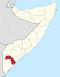
Jubbada Dhexe (Middle Jubba ; Arabic جوبا الوسطى, DMG Ǧūbbā al-Wusṭā ) is a region ( gobolka ) in southern Somalia . Their capital is Buaale .
The region lies on the Indian Ocean and is named after the Jubba River, which flows through it. The largest city is Jilib , where the Shabeelle River joins the Jubba in rainy years. Jubbada Dhexe consists of the three districts of Buaale, Jilib and Sakow.
Unlike much of Somalia, Jubbada Dhexe is fertile because of its location in the Jubba Valley. Nevertheless, the civil war in Somalia led to food shortages and hunger here too. In 2006 there were floods on the Jubba.
The inhabitants of Middle Juba include various Somali - Clans on. The Bantu ethnic minority in Somalia is represented in the Gosha area on the Jubba.
In 2015, Jubbada Dhexe was the region with the lowest human development index in the world.
swell
- ↑ population estimation survey 2014 ( UNFPA ) table A3
- ↑ z. B. Fews.net: Clan Conflict Threats Food Security in Buaale, Middle Juba Region (2003) ( Memento of the original from August 29, 2006 in the Internet Archive ) Info: The archive link was automatically inserted and not yet checked. Please check the original and archive link according to the instructions and then remove this notice.
- ↑ UNICEF Somalia: Press releases
- ^ Sub-national HDI - Area Database - Global Data Lab. Accessed August 6, 2018 .
Bakool | Banaadir | Bay | Galguduud | Gedo | Hiiraan | Jubbada Dhexe | Jubbada Hoose | Shabeellaha Dhexe | Shabeellaha Hoose
Puntland Bari / Karkaar | Mudug | Nugaal
Somaliland Awdal | Sanaag | Sool | Togdheer | Woqooyi Galbeed (Maroodi Jeex) | Saaxil
| Colonial times |
|
||||||
| After the Second World War |
|
||||||
|
From independence to civil war |
|
||||||
|
Civil war period, collapse of the central state (claims to recognition) |
|
||||||
| New constitution from 2012 |
|