
Kirchlauter
| coat of arms | Germany map | |
|---|---|---|

|
Coordinates: 50 ° 3 ' N , 10 ° 43' E |
|
| Basic data | ||
| State : | Bavaria | |
| Administrative region : | Lower Franconia | |
| County : | Hatred Mountains | |
| Management Community : | Ebelsbach | |
| Height : | 344 m above sea level NHN | |
| Area : | 16.91 km 2 | |
| Residents: | 1308 (Dec. 31, 2019) | |
| Population density : | 77 inhabitants per km 2 | |
| Postcodes : | 96166, 97486 | |
| Area code : | 09536 | |
| License plate : | HAS, EBN, GEO , HOH | |
| Community key : | 09 6 74 160 | |
| Community structure: | 9 districts | |
| Association administration address: | Georg-Schäfer-Str. 56 97500 Ebelsbach |
|
| Website : | ||
| Mayor : | Karl-Heinz Kandler ( SPD ) | |
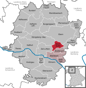
| Location of the municipality of Kirchlauter in the Haßberge district | ||
  |
||

Kirchlauter is a municipality in the Lower Franconian district of Haßberge and a member of the Ebelsbach administrative community .
geography
Geographical location
The villages of Kirchlauter, Neubrunn and Pettstadt are located in the Main-Rhön region (Bavarian planning region 3) in the side valleys of the Main and in the southern part of the Haßberge Nature Park , about 30 km west of Bamberg and 45 km east of Schweinfurt . The Lauter flows through the town and ends at Baunach in the river Baunach , shortly before it flows into the Main. The Neubrunn, which flows into the Ebelsbach, has its source at the so-called Bollerbrunnen. This also flows into the Main after about 15 kilometers . Kirchlauter is the center of the so-called Holy Lands .
Community structure
The municipality of Kirchlauter has nine districts:
- the village of Goggelgereuth with 34 inhabitants, first mentioned in 1373
- the wasteland of Hecklesmühle with two inhabitants, first mentioned in 1445
- the parish village of Kirchlauter with 618 inhabitants, first mention 1145
- the wasteland of Klaubmühle with five inhabitants, first mentioned in 1575
- the church village Neubrunn with 670 inhabitants, first mentioned 1151
- the wasteland pass mill to the right of the stream (Ebelsbach) with six inhabitants, first mentioned in the 16th century
- the village of Pettstadt with 67 inhabitants, first mentioned 1145
- the hamlet of Weikartslauter , formerly Mittelmühle, with three inhabitants, first mentioned in 1251
- the desert Winterhof , formerly Hegenberg, with nine inhabitants, first mentioned in 1502
The following districts have existed since the regional reform in 1978 : Kirchlauter, Neubrunn, Pettstadt.
Neighboring communities
Neighboring communities are starting from the north in a clockwise direction: Ebern , Rentweinsdorf , Breitbrunn , Ebelsbach , Zeil am Main and Königsberg in Bavaria .
history
Until the church is planted
The Lutere settlement , located between Ebern and Eltmann am Lauterbach and a very old elevated road, was probably formed from a Franconian forest area. The place was first mentioned in 1145 with "Marquard de Lutere". Both the Bamberg monasteries and the ministerials of the Würzburg bishopric have been known as fiefdoms since the 13th century . By enfeoffing a ministerial pilot in 1373, the "Kirchluter", similar to today's name, is attested for the first time. The location on the bishopric and diocesan border from Würzburg to Bamberg probably led to the special status of a tithe exemption of the place. The rulership of the village was originally divided. Half owned by various heirs and from 1502 to 1803 the von Guttenberg family . The other half belonged to the pastor of the place since the middle of the 15th century. Under the Würzburg prince-bishop Johann Gottfried von Guttenberg , the family share and that of the local pastor were combined in 1689/90 and a separate high institute and tithe Kirchlauter was established. The same bishop had a family castle built by H. Zimmer in place of a medieval moated castle in 1689/90, which was not completed until 1740 and which has been in the possession of the Schenk von Stauffenberg family since 1981 .
In 1818 the political community was formed and in 1820 a patrimonial court .
19th and 20th centuries
In 1862 Kirchlauter was incorporated into the Baunach regional court and the Ebern office.
Kirchlauter has been part of the Haßberge district since 1971 and since 1978 with the districts of Neubrunn, Pettstadt, Goggelgereuth, Hecklesmühle Winterhof, Weikartslauter, Passmühle right of the stream and the Klaubmühle, part of the Ebelsbach administrative community .
The village of Kirchlauter had market rights from the 16th to the 20th century . From the 17th to the 20th century, clay mining and pottery manufacturers as well as sandstone mining were important.
History of the parish and the local church

Originally, the settlement was cared for by the Zeil mother parish in the Middle Ages , until the Würzburg bishop Gottfried Schenk von Limpurg trained it in 1446 to become the independent parish of Kirchlauter with the branches Neubrunn, Dörflis , Kottenbrunn , Köslau , Pettstadt, Goggelgereuth and Weikartslauter rose. At that time there were only chapels in Neubrunn and Dörflis. Because Dörflis, Köslau and Kottenbrunn were on Saxon territory, these places were looked after by Protestants during the Reformation and from 1592 onwards by their own Protestant parish. In Kirchlauter, Protestant influences were pushed back between 1565 and 1579 by the Würzburg bishop in 1580 and since then the parish, which was originally administered by the Gerolzhofen dean's office and from around 1560 by the Ebern dean's office, has been Catholic again.
The Church of the Assumption of Mary from the 14th century is still in ruins with medieval frescoes in the old choir . Today's baroque parish church was built between 1751 and 1754 according to the plans of the Goßmannsdorf master builder Agidius Bierdimpfl. In 1759 the Würzburg auxiliary bishop Daniel von Gebsattel consecrated the church. Little is known about the baroque furnishings of the church, as it was mostly paid for by private foundations of the Guttenberg village authorities and there is no evidence. The artist Georg Joseph Mutschele from Bamberg has only survived of two figures. The ceiling frescoes in the choir and nave were created in 1897 by the Munich company Kaspar Lessig and Co.
The rectory was built by Johann Schmeltzing from Rüdenhausen between 1735 and 1738 not far from Guttenberg's moated castle in the baroque style.
Incorporations
Pettstadt has been part of the Kirchlauter community since April 1, 1971. On May 1, 1978, Neubrunn was incorporated into the municipality of Kirchlauter with its Paßmühle district on the right of the stream.
Population development
- 1961: 1363 inhabitants
- 1970: 1369 inhabitants
- 1987: 1391 inhabitants
- 1991: 1442 inhabitants
- 1995: 1472 inhabitants
- 2000: 1500 inhabitants
- 2005: 1444 inhabitants
- 2010: 1381 inhabitants
- 2015: 1318 inhabitants
politics
Municipal council
The Kirchlauter municipal council has 13 members including the full-time mayor.
| CSU | SPD | Boy list | Free voters | total | |
| 2014 | 4th | 6th | 2 | 1 | 13 seats |
| CSU | SPD | Boy list | Free voters | total | |
| 2008 | 7th | 4th | 1 | 1 | 13 seats |
| CSU | SPD | Boy list | Free voters | total | |
| 2002 | 7th | 3 | 3 | n / A | 13 seats |
mayor
Karl-Heinz Kandler (SPD) has been mayor since 2014. He prevailed in the 2014 election with 58.81% of the votes against incumbent Jochen Steppert (CSU); In 2020 he was re-elected with 59.7% of the vote. Until 2008, Peter Kirchner (CSU) was the head of the community.
coat of arms
The description of the municipal coat of arms adopted in 1969 reads: “Divided by silver and blue; above a red lily, below a golden heraldic rose. "
Culture and sights


- Moated castle of the barons von und zu Guttenberg in Kirchlauter from the 17th century with park, built by master builder Heinrich Zimmer. Today the castle estate is owned by Elisabeth Countess Stauffenberg, born Freiin zu Guttenberg, wife of Franz Ludwig Schenk Count von Stauffenberg and sister of the conductor Enoch zu Guttenberg
- Rococo church Maria Himmelfahrt in Kirchlauter with what is said to be the oldest fresco in Franconia from around 1375, built in 1752
- Baroque church of St. Andreas and St. Katharina in Neubrunn, built from 1777 to 1779
- Blacksmith Museum in Kirchlauter, built in 1923 and used as a forge until the 1970s. The exhibition rooms and the blacksmith forge , anvil and Ziehbalg can be visited by appointment
- Nice town center of Neubrunn with half-timbered and sandstone houses, church, school and fountain
- Kneipp facility fed by a spring at the entrance to Neubrunn
- Training apiary in Kirchlauter
- Adventure nature trail on the topic of orchards located on the Altlautersee with 69 different types of fruit trees
Monuments

Architectural monuments
Soil monuments
Economy and Infrastructure
economy
According to official statistics, in 2017 there were 103 employees subject to social security contributions at the place of work and 556 employees at the place of residence; the number of out-commuters thus outnumbered 453 people. In 2016 there were 14 farms (in 1999 there were 40); 301 hectares were used for agriculture, of which 209 hectares were arable and 92 hectares were permanently green.
traffic
The villages of Kirchlauter, Neubrunn and Pettstadt have the following transport connections:
- approx. ten kilometers to the federal motorway 70 with the Ebelsbach - Eltmann junction
- Approx. nine kilometers in the direction of Ebelsbach to Bundesstraße 26
- Approx. twelve kilometers in the direction of Ebern / Rentweinsdorf to the federal road 279
- approx. nine kilometers to the Ebelsbach-Eltmann train station ( Bamberg – Würzburg line )
- approx. ten kilometers to the Rentweinsdorf-Treinfeld train station (regional train Ebern - Bamberg )
- Breitbrunn - Kirchlauter - Bamberg bus line
education
There are the following institutions (as of 2018):
- Two day-care centers with 69 places and 50 children
- An elementary school with four classes, five teachers and 73 students
Personalities
- Jörg Hofmann (1660–1714), master builder and carpenter
- Nina Schenk Countess von Stauffenberg (1913–2006), widow of Colonel Claus Schenk Graf von Stauffenberg , buried on April 8, 2006 in Kirchlauter
literature
- Norbert Kandler: Kirchlauter - history of the parish and its surroundings up to the baroque period . Echter Verlag, Würzburg 1985, ISBN 3-429-00933-2
- Norbert Kandler: Neubrunn - branch and place of worship . Festschrift published by the Kirchlauter Parish Office and the Neubrunn Parish Council, 1984.
- Norbert Kandler in: Handbook of Historic Places. Bavaria II Franconia , published by HM., Körner / A. Schmid, Stuttgart 2006, p. 262 f.
- Norbert Kandler: Lutere - Lauter - Kirchlauter , Würzburg 1959.
- Norbert Kandler: Churches, chapels and castle in the parish of Kirchlauter , Kirchlauter 1996.
- Norbert Kandler: The Mariae-Himmelfahrtskirche zu Kirchlauter , Aschaffenburg 2009.
- Norbert Kandler, Herbert Roller: Neubrunn - Ein Haßbergdorf , Aschaffenburg 2001
Individual evidence
- ↑ "Data 2" sheet, Statistical Report A1200C 202041 Population of the municipalities, districts and administrative districts 1st quarter 2020 (population based on the 2011 census) ( help ).
- ↑ Kirchlauter community in the local database of the Bavarian State Library Online . Bavarian State Library, accessed on November 11, 2018.
- ↑ Population figures according to the citizens' meeting on August 28, 2014
- ↑ Kirchlauter and its districts
- ^ Wilhelm Volkert (ed.): Handbook of Bavarian offices, communities and courts 1799–1980 . CH Beck, Munich 1983, ISBN 3-406-09669-7 , p. 453 .
- ↑ a b c Federal Statistical Office (ed.): Historical municipality directory for the Federal Republic of Germany. Name, border and key number changes in municipalities, counties and administrative districts from May 27, 1970 to December 31, 1982 . W. Kohlhammer GmbH, Stuttgart / Mainz 1983, ISBN 3-17-003263-1 , p. 760 .
- ↑ https://www.vg-ebelsbach.de/de/kirchlauter/vereine-kultur-freizeit-tourismus/schmiedemuseum.php
- ↑ https://www.vg-ebelsbach.de/de/kirchlauter/vereine-kultur-freizeit-tourismus/kneippbecken-neubrunn.php
- ↑ http://www.kvhassberg.lvbi.de/1784304.html
- ↑ https://naturgenuss-kirchlauter.de/
Web links
- Homepage: Kirchlauter in the Ebelsbach administrative community
- Entry on the coat of arms of Kirchlauter in the database of the House of Bavarian History

Aidhausen | Breitbrunn | Bundorf | Burgpreppach | Ebelsbach | Boars | Eltmann | Ermershausen | Gädheim | Hassfurt | Hofheim in Lower Franconia | Kirchlauter | Knetzgau | Königsberg in Bavaria | Maroldsweisach | Oberaurach | Pfarrweisach | Rauhenebrach | Rentweinsdorf | Riedbach | Sand am Main | Stettfeld | Theres | Untermerzbach | Wonfurt | Zeil am Main