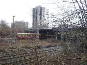
Kniprodestrasse bridge
Coordinates: 52 ° 32 ′ 10 ″ N , 13 ° 26 ′ 52 ″ E
| Kniprodestrasse bridge | ||
|---|---|---|
| use | Road traffic, pedestrians | |
| Convicted | Kniprodestrasse | |
| Crossing of | Ringbahn | |
| place | Berlin-Prenzlauer Berg | |
| construction | multi-column reinforced concrete girders, two separate lanes | |
| overall length | 40.0 m | |
| width | 20.0 m each, including 10 m on foot | |
| Clear height | about 5 m | |
| start of building | 1978 | |
| completion | 1979 | |
| location | ||
|
|
||
The Kniprodestrasse Bridge is a road bridge over the Ringbahn in the Berlin district of Pankow , Berlin-Prenzlauer Berg , which has existed with interruptions since the end of the 19th century.
Location and naming
The Kniprodestrasse bridge connects the streets and residential areas northeast and southwest of the Berlin S-Bahn ring. The Kniprodestraße and named after her road bridge received their names after the Crusaders Winrich von Kniprode . The bridge was interrupted between 1945 and the 1970s. At that time the street was called Artur-Becker-Straße , with which the Berlin magistrate had honored the Spain fighter Artur Becker .
Creation and destruction
An old Berlin city map from 1895 shows the existence of a bridge at the current location, over which the Verlorne Weg ran from Friedrichshain to the Jewish burial ground in Weissensee to the north-east. This south-west-north-east bridge crossed the rails of the North Ring Railway, which opened in 1871, without barriers . When houses, schools and the municipal gasworks were built in this area from the beginning of the 20th century, Verlornen Weg became Kniprodestrasse in 1901 .
Specialists of the German Wehrmacht had blown up the existing bridge at the beginning of 1945 in order to make it more difficult for the Soviet army units advancing from the east via Kniprodestrasse to get to the inner city of Berlin. A list of structural damage with maps prepared in the summer of 1945 on behalf of the Berlin magistrate shows the interrupted road layout in the area of the tracks.
reconstruction
From around 1950 a wooden makeshift bridge was built on the preserved stone abutments of the old bridge (popularly known as the "Black Bridge"), which made it possible for pedestrians and cyclists to cross the tracks. When most of the war damage in the Berlin cityscape had been repaired in the 1960s and a new residential area was completed in Kniprodestrasse in 1974 , the road bridge was rebuilt. The construction time is documented on the iron bridge railing as 1979. The new bridge is an unadorned traffic structure with two separate lanes and three lanes each. The roadways are supported on several pairs of stands, in the middle they are secured with guardrails and covered with gratings. The traffic authorities gave it the name Artur-Becker-Brücke after the street leading over it, which was renamed Artur-Becker-Straße in September 1974 . A bus line now used the new road connection (A57). On November 24, 1998, a few years after the fall of the Wall , those responsible for the district renamed the street to Kniprodestrasse and the bridge to Kniprodestrassebrücke .
In the period 2002/2004 extensive renovation work was carried out on the bridge structure and the adjacent roads. The overhaul of the bridge was financed with funds from the State of Berlin, the federal government and the European Union ; a sign on a corner pillar informs about this.
Attractions in the neighborhood
- Volkspark Anton Saefkow , which was formed from piled up war debris
- A residential area northeast of the Kniprodestrasse bridge at Einsteinpark with artistic statues such as Three Graces (1983, Baldur Schönfelder ; Hanns-Eisler-Strasse), Two Goats on the Bridge (1977, Stephan Horota ; Einsteinstrasse), Einstein and Milena (Einsteinpark)
- Velodrome
- Old gas station, rebuilt and modernized
- Tram depot at Kniprodestrasse 24, which is still partly used by the BVG. The depot (Ost, BSt: 25) was used for regular services from 1908 to 1923, after which it was used as a track storage facility and a depot for utility vehicles (ATw depot). Parts of the original total area (43,701 square meters) were sold around the year 2000 and two supermarkets are built on. The remaining area is used by the BVG as a warehouse, track construction yard, and car shed for work railcars.
Web links
Individual evidence
- ↑ Berlin plan from 1895 ( page no longer available , search in web archives ) Info: The link was automatically marked as defective. Please check the link according to the instructions and then remove this notice.
- ↑ Kniprodestrasse. In: Street name lexicon of the Luisenstädtischer Bildungsverein (near Kaupert )
- ↑ Municipal plan of war damage 1945 ( page no longer available , search in web archives ) Info: The link was automatically marked as defective. Please check the link according to the instructions and then remove this notice.
- ↑ Berlin plan from 1960 with the narrow temporary bridge ( memento of the original dated December 2, 2015 in the Internet Archive ) Info: The archive link was inserted automatically and has not yet been checked. Please check the original and archive link according to the instructions and then remove this notice.
- ↑ List of street renaming that has taken place. ( Memento of March 7, 2010 in the Internet Archive ) (PDF) Office for Statistics Berlin-Brandenburg; Retrieved March 23, 2009
- ↑ Caught cold - winter paralyzed road construction sites . In: Berliner Zeitung , March 10, 2003.
- ^ "Schotterschnecke" ( Memento from March 4, 2008 in the Internet Archive ) Private homepage with information about Berlin tram depots


