Langeneß
| Langeneß | ||
|---|---|---|
| Aerial view of Langeness, Oland in the background on the left | ||
| Waters | North Sea | |
| Archipelago | North Frisian Islands | |
| Geographical location | 54 ° 38 '14 " N , 8 ° 36' 47" E | |
|
|
||
| length | 10 km | |
| width | 1.4 km | |
| surface | 9.56 km² | |
| Highest elevation | 1 m | |
| Residents | about 100 10 inhabitants / km² |
|
| Langeneß between Norderaue (Norder Aue) and Süderaue (Süder Aue) on a map from 1864 | ||

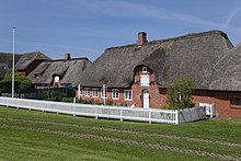
Langeneß [ laŋəˈnɛs ] ( Danish Langenæs , North Frisian Nees ) is a Hallig in the area of the North Frisian Islands off the Schleswig-Holstein North Sea coast between the large priels Norderaue and Süderaue .
Together with Hallig Oland , which is adjacent to the east , Langeneß forms the municipality of the same name . Both Halligen are connected to each other and the mainland via a rail link ( Halligbahn Dagebüll – Oland – Langeneß ) .
history
Before the Burchardi flood of 1634, Langeneß formed the Hallig Alt-Langeneß together with the Hallig Oland and other land masses.
In 1802, today's Langeneß still consisted of three individual Halligen: Langeneß (east), Butwehl (southeast) and Nordmarsch (west), which grew together up to 1869 through dam construction, lahnungen and natural growth. The original name of the island that has grown together was Nordmarsch-Langeness.
Butwehl may in Waldemars Erdbuch mentioned island Hwäler.
Langeneß became smaller over the centuries. Before the flood of 1825, 70 houses and 187 inhabitants were counted. In 1850 there were 50 houses on 14 terps, and 30 houses in 1905/06. In 1873 the Hallig was 1179 hectares in size. After the survey of 1882 it was only 1025 ha. Today, Langeneß is the largest of the Halligen with a length of about 10 km, a width of up to 1400 m and a total size of 956 ha.
Transport, economy and tourism
The Hallig is connected to the Hallig Oland by a cart through the Wadden Sea and from there to the mainland near Dagebüll . The "Lorenbahnhof" is located in the northeast of the Hallig near the Bandixwarft. At the other end of Langeneß in the southwest at Rixwarft there is the only landing stage with regular ferry connections. The ferry Hilligenlei of the Wyker Dampfschiffs-Reederei Föhr-Amrum operates from here to Wittdün on the island of Amrum (only in the summer half-year) and via the Hallig Hooge to the Schlüttsiel ferry port on the mainland. It is possible to translate by car and use the car on the island. However, there is practically only one road on Langeneß between the ferry terminal and the Lorenbahnhof with short branches to the individual terps. There is no petrol station.
Langeness has been supplied with electricity from the mainland via a cable since 1954. The drinking water supply is now also ensured via a connection line to the coast.
Besides the agriculture (mostly in part-time ) and / or employment in coastal protection (the country for Coastal Defense, National Park and Conservation Schleswig-Holstein ), the tourism an important source of income for residents. While the accommodation on the islets mostly takes place in hotels and apartments , overnight stays in a four-star hotel are also possible on Mayenswarf.
In the far west of the old Peterswarft stands the Nordmarsch lighthouse, which was built in 1902 and is 11.50 meters high.
The municipality of Langeneß has two postcodes : on the one hand 25863 for Hallig Langeneß and on the other hand 25867 for Hallig Oland. Langeneß is the smallest municipality in Germany in terms of inhabitants with several postcodes.
Representation in museums, art and literature
The ancestors of the important philosopher and educator Friedrich Paulsen (1846–1908) came from Langeneß, Nordmarsch and Oland. In his memoirs from my life he wrote about a visit to Nordmarsch-Langeness in 1903: "The islands of the blessed cannot be more beautiful."
The Klimahaus Bremerhaven presents in its part of the exhibition “Reise” as the last stop on the 8th degree of longitude Langeness. A former community nurse at Peterhaitzwarf is portrayed as the "ambassador" and "face of Langeness". In fact, Langeness is closer to the 9th degree of longitude.
In 1986, director Christoph Schlingensief made the film Egomania - Island Without Hope , including on Langeneß.
In the early 1990s, the Hamburg film director Tevfik Başer set his German-Turkish love story Farewell Strangers , which was released in 1993, to the Hallig.
The Hallig novel Godber Godbersen by Elfriede Rotermund (1928) plays in part on Langeneß. Most of the Sönke-Hansen thrillers by Kari Köster-Lösche are set on Langeneß , and their framework story includes the change in Hallig life at the end of the 19th century through bank reinforcement and tourism.


