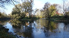
Lauchert
The Lauchert is a left tributary of the Danube in Baden-Württemberg .
geography
Lauchert spring


The Lauchert rises from several sources around Melchingen in the Zollernalb district . Only one officially Lauchertquelle called karst spring , east of the town, showered the year. The longer and at times richer in water Willmandingener Quellbach dries up in summer.
course
On its way south, the Lauchert crosses or grazes the following communities: The Burladingen districts of Melchingen , Stetten unter Holstein and Hörschwag , the Trochtelfingen districts of Hausen an der Lauchert and Mägerkingen , through Gammertingen and its suburbs Mariaberg and Bronnen , through the cities of Hettingen and Veringenstadt as well as their suburbs Hermentingen and Veringendorf , through the Sigmaring district of Jungnau , through Bingen and its suburb Hitzkofen and finally through the Sigmaringdorf district of Laucherthal , before it flows into the Danube in Sigmaringendorf .
Protected areas
The Lauchert flows through protected areas for almost its entire length. The former regional council of South Württemberg-Hohenzollern in Tübingen established three landscape protection areas by ordinance of September 13, 1955 . All three areas are called Laucherttal with side valleys :
- In the former district of Hechingen (today Zollernalbkreis) an area of 345.0 hectares was placed under landscape protection with the no. 4.17.044 between Melchingen and Hörschwag .
- In the district of Reutlingen , a 213.0 hectare protected area was created in the area of the city of Trochtelfingen with the no. 4.15.002.
- In its lower reaches in the district of Sigmaringen , the Lauchert crosses between Gammertingen and Sigmaringendorf a 1204.0 hectare landscape protection area, which bears the number 4.37.001.
Between Stetten and Hörschwag, the Lauchert also touches the nature reserve Bei der Mühle (protected area number 4087, size 7.01 hectares), which was placed under protection on February 23, 1981.
Tributaries
- Erpf (estuary near Stetten under Holstein )
- Seckach (mouth south of Mägerkingen )
- Fehla (mouth south of Hettingen )
- Bach from the Gallus spring (rises and flows into Hermentingen)
- Fischbach (mouth in Hitzkofen )
River history
Others
The Lauchertsee, which was artificially created in the 1970s, flows through at Mägerkingen .
The rolling mill near Hörschwag became known nationwide as " Albmühle " through the 75-minute documentary by Rudolf Werner , which was first broadcast on ARD on December 25, 1999 , called "The Lord knows what happens to us - The Sisters of the Albmühle" .
Particularly noteworthy are the Gallus spring , the old town of Veringenstadt and the events from the climatically troubled Quaternary , when the Alps glaciated several times. In the last roughly one million years in particular, the Lauchert was affected several times by serious changes on the Upper Danube. One of the results of these changes is the Bittelschießer Täle with the Bittelschießer cave and the Bittelschieß ruins .
The name is said to have come from around 400 BC. Celts settled in the area (Lochert, Luchat, later Luachert) originate.
The floods in Central Europe in 2013 at the end of May and the beginning of June also hit the Lauchert after days of heavy rain. Among other things, large parts of Stetten under Holstein , Hausen an der Lauchert , Veringenstadt and Jungnau were under water.
Individual evidence
- ↑ a b State Institute for the Environment Baden-Württemberg (LUBW) ( information )
- ↑ Flood forecast center , State Institute for the Environment Baden-Württemberg (adopted on July 20, 2017)
- ^ German Hydrological Yearbook Danube Region 2006 Bavarian State Office for the Environment, p. 85, accessed on October 4, 2017, at: bestellen.bayern.de (PDF, German, 24.2 MB).
- ↑ Films by Rudolf Werner ( Memento of the original from October 31, 2013 in the Internet Archive ) Info: The archive link was inserted automatically and has not yet been checked. Please check the original and archive link according to the instructions and then remove this notice. .
- ↑ “Lord God knows what is happening to us” (documentary) ( Memento of the original from January 27, 2013 in the Internet Archive ) Info: The archive link was automatically inserted and not yet checked. Please check the original and archive link according to the instructions and then remove this notice. , EKD.
Web links
- Profile of the landscape protection area in the protected area directory of the LUBW - Reutlingen district
- Profile of the landscape protection area in the protected area directory of LUBW - Sigmaringen district
- Profile of the landscape protection area in the protected area directory of the LUBW - Zollernalbkreis


