
District of Hechingen
| coat of arms | Germany map | |
|---|---|---|

|
Coordinates: 48 ° 20 ' N , 8 ° 55' E |
|
| Basic data (as of 1972) | ||
| Existing period: | 1925-1972 | |
| State : | Baden-Württemberg | |
| Administrative region : | South Württemberg-Hohenzollern | |
| Administrative headquarters : | Hechingen | |
| Area : | 412 km 2 | |
| Residents: | 58,175 (May 27, 1970) | |
| Population density : | 141 inhabitants per km 2 | |
| License plate : | HCH | |
| Circle key : | 08 4 36 | |
| Circle structure: | 47 parishes | |
| District Administrator : | Hans-Jörg Mauser ( CDU ) | |
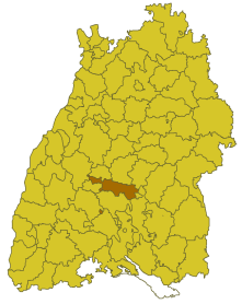
| Location of the district of Hechingen in Baden-Württemberg | ||
  |
||

The district of Hechingen was a district in Baden-Württemberg that was dissolved in the course of the district reform on January 1, 1973. The administrative seat was Hechingen .
geography
location
The district of Hechingen was in the south of Baden-Württemberg .
Geographically, it mainly had a share in the foreland of the western Swabian Alb .
Neighboring areas
Its neighbors were 1972 in a clockwise direction beginning in the north of Horb , Tübingen , Reutlingen , Sigmaringen , Balingen , the south of the district of Horb ( exclave ) and Freudenstadt .
history
Before 1806 the area of the later district of Hechingen belonged to the principalities of Hohenzollern-Hechingen , Hohenzollern-Haigerloch and, to a lesser extent, to the principality of Hohenzollern-Sigmaringen . The Principality of Hohenzollern-Hechingen consisted of the Hohenzollern Oberamt Hechingen, the Oberamt Haigerloch and Glatt belonged to Hohenzollern-Sigmaringen before 1850. After the transition to Prussia in 1850, the Oberamt Glatt was combined with the Oberamt Haigerloch in 1854 . The two remaining upper offices of Hechingen and Haigerloch were combined to form the district of Hechingen in 1925, with three municipalities being incorporated into the upper office of Gammertingen , which belongs to Hohenzollern-Sigmaringen .
After the Second World War, the district of Hechingen became part of the new federal state of Württemberg-Hohenzollern and, following the reorganization of the federal states in the southwest in 1952, became part of Baden-Württemberg . Thereafter the district belonged to the administrative district of Südwürttemberg-Hohenzollern , which was later renamed the administrative district of Tübingen .
With effect from January 1, 1973, the district of Hechingen was dissolved. The greater part was combined with the former Württemberg district of Balingen, which was also dissolved, as well as two municipalities of the former Baden district of Stockach , which was dissolved to form the new Zollernalb district , which became the legal successor of the Hechingen district. The county seat of the new district was Balingen . Six communities in the district of Hechingen were assigned to the enlarged district of Freudenstadt , three others (including Wilflingen as early as 1969) to the enlarged district of Rottweil . Wilflingen was an exclave of the Hechingen district until 1969.
Population development
All population figures are census results.
|
politics
District Administrator
The Oberamtmen or district administrators of the Oberamt or District Hechingen 1834–1972:
- 1834–1839: Josef Stehle
- 1839–1841: Friedrich Milden
- 1841–1848: Constantin Werner
- 1848–1849: Georg Baur (clerk)
- 1849–1850: Kaspar Lorch
- 1850–1854: Thaddäus Bachmann (acting)
- 1854–1868: Wilhelm Frank von Fürstenwerth
- 1868–1877: Adolf Frank von Fürstenwerth
- 1877–1879: Wilhelm von Natzmer
- 1879–1881: Franz Leopold Gehle
- 1881–1883: Otto von Westhoven
- 1883–1884: Bernhard von Schenck
- 1884–1888: Axel von Schwerin
- 1889–1891: Arnold Ludwig Senfft von Pillsach
- 1891–1903: Philipp Longard
- 1903–1918: Karl von Schoenfeld
- 1918–1921: Paul Paehler
- 1921–1924: Paul Schaaff
- 1924–1945: Paul Schraermeyer
- 1945: Clemens Moser
- 1945–1946: Peter Remark
- 1946–1966: Hans Speidel
- 1966–1972: Hans-Jörg Mauser
coat of arms
The coat of arms of the district of Hechingen showed a red-armored, black eagle sitting in silver on a tinned red shield base, which holds a shield with its fangs made of silver and black. The coat of arms was awarded by the Ministry of the Interior of Baden-Württemberg on October 2, 1958. Before that, the district used the quartered Hohenzollern shield, especially since the district mainly belonged to the former principality of Hohenzollern-Hechingen. The eagle and the battlements are intended to refer to Prussia and Hohenzollern Castle , the ancestral seat of the House of Hohenzollern .
Economy and Infrastructure
traffic
The district was opened up by the B 27 and B 463 as well as by several state roads and district roads. Today's A 81 did not yet exist in the former district area and was only opened to traffic in 1978.
Communities
From 1938 onwards, 47 communities belonged to the district of Hechingen, two of them towns.
On March 7, 1968, the state parliament of Baden-Württemberg set the course for a community reform . With the law to strengthen the administrative power of smaller municipalities , it was possible for smaller municipalities to voluntarily unite to form larger municipalities. The beginning in the district of Hechingen was made on August 1, 1971 by the municipality of Stetten bei Hechingen, which merged with the city of Hechingen . In the period that followed, the number of municipalities steadily decreased until the district of Hechingen was finally dissolved on January 1, 1973. On January 1, 1969, the community of Wilflingen moved to the Rottweil district . However, it was not incorporated into the Wellendingen community until January 1, 1974 .
The largest municipality in the district was the district town of Hechingen . The smallest community was Beuren.
In the table, the municipalities of the district of Hechingen are before the municipal reform. The population figures refer to the census results in 1961 and 1970.
License Plate
On July 1, 1956, the district was assigned the distinctive sign HCH when the vehicle registration number that is still valid today was introduced . It was issued until December 31, 1972. Due to the license plate liberalization , it has been available in the Zollernalb district since February 25, 2013 and also in the Freudenstadt district since February 19, 2018.
literature
- Hans Speidel: The old district of Hechingen . In: Erhard Lazi (ed.), The Zollernalbkreis . Konrad Theiss Verlag , Stuttgart 1979, pp. 158–168, ISBN 3-8062-0205-2 (not evaluated)
Individual evidence
- ↑ a b Federal Statistical Office (ed.): Historical municipality register for the Federal Republic of Germany. Name, border and key number changes in municipalities, counties and administrative districts from May 27, 1970 to December 31, 1982 . W. Kohlhammer, Stuttgart / Mainz 1983, ISBN 3-17-003263-1 , p. 528 f .
.svg)
Basking | Backnang | Baden-Baden | Balingen | Biberach | Boeblingen | Bruchsal | Book | Bühl | Calw | Crailsheim | Donaueschingen | Ehingen | Emmendingen | Esslingen | Freiburg (city) | Freiburg (State) | Freudenstadt | Friedrichshafen | Göppingen | Hechingen | Heidelberg (city) | Heidelberg (Country) | Heidenheim | Heilbronn (city) | Heilbronn (Land) | Black Forest | Horb | Karlsruhe (city) | Karlsruhe (State) | Throat | Constance (city) | Constance (Country) | Künzelsau | Lahr | Leonberg | Loerrach | Ludwigsburg | Mannheim (city) | Mannheim (State) | Mergentheim | Mosbach | Muellheim | Münsingen | Neustadt | Nürtingen | Offenburg | Öhringen | Pforzheim (city) | Pforzheim (Country) | Rastatt | Ravensburg | Reutlingen | Rottweil | Säckingen | Saulgau | Schwäbisch Gmünd | Schwäbisch Hall | Sigmaringen | Sinsheim | Stockach | Stuttgart | Tauberbischofsheim | Tettnang | Tübingen | Tuttlingen | Überlingen | Ulm (city) | Ulm (State) | Vaihingen | Villingen | Villingen-Schwenningen | Waiblingen | Waldshut | Cheeks | Wolfach