
District of Göppingen
| coat of arms | Germany map |
|---|---|

|

Coordinates: 48 ° 42 ' N , 9 ° 39' E |
| Basic data | |
| State : | Baden-Württemberg |
| Administrative region : | Stuttgart |
| Region : | Stuttgart |
| Administrative headquarters : | Goeppingen |
| Area : | 642.36 km 2 |
| Residents: | 257,253 (Dec. 31, 2018) |
| Population density : | 400 inhabitants per km 2 |
| License plate : | GP |
| Circle key : | 08 1 17 |
| NUTS : | DE114 |
| Circle structure: | 38 parishes |
| Address of the district administration: |
Lorcher Strasse 6 73033 Göppingen |
| Website : | |
| District Administrator : | Edgar Wolff ( FW ) |
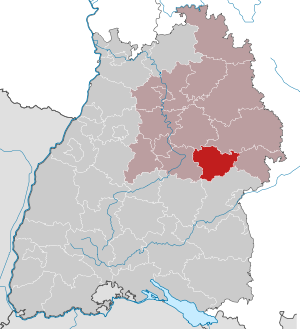
| Location of the district of Göppingen in Baden-Württemberg | |
  |
|
The district of Göppingen is a district in Baden-Württemberg. It belongs to the region of Stuttgart in Stuttgart Region and extends from north to south of Adelberg to High City , in east-west direction of Ebersbach an der Fils to Boehmenkirch .
geography
location
The district of Göppingen lies on the edge of the Swabian Alb . The Fils flows through the district , a right tributary of the Neckar , which flows into Plochingen . The river comes from Wiesensteig (Filsursprung) via Geislingen an der Steige and flows through the district in an east-west direction to Ebersbach an der Fils , where it leaves the district and then flows into the Neckar at Plochingen ( Esslingen district ). The district area extends over an altitude of 266 m above sea level. NN in Ebersbach an der Fils up to 838 m above sea level. NN in Hohenstadt on the Alb plateau.
places
The list of places in the district of Göppingen contains around 255 places ( towns , villages , hamlets , farms and living spaces ) in the district of Göppingen in the geographical sense.
Neighboring areas
The district borders clockwise in the north, beginning with the districts of Rems-Murr-Kreis , Ostalbkreis , Heidenheim , Alb-Donau-Kreis , Reutlingen (less than 500 m) and Esslingen .
Division of space

According to data from the State Statistical Office , as of 2015.
nature
The district of Göppingen has the following nature reserves . According to the protected area statistics of the State Institute for the Environment, Measurements and Nature Conservation Baden-Württemberg (LUBW), 2,876.77 hectares of the district are under nature protection, that is 4.48 percent.
- Autal : 45.0 ha; District Bad Überkingen
- Bärentobel : 9.8 ha; Gemarkungen Uhingen and Holzhausen
- Dalisberg : 30.5 hectares; District of Unterböhringen
- Eybtal with parts of the Längen- and Rohrachtal : 1331.0 ha; Landmarks Schnittlingen , Steinenkirch and Treffelhausen , Donzdorf , Geislingen an der Steige , Eybach , Stötten , Waldhausen and Weiler
- Galgenberg : 88.0 ha; Gemarkungen Auendorf and Deggingen
- Haarberg-Wasserberg : 109.6 ha; District Reichenbach im Täle
- Hausener Wall : 77.5 ha; Districts Bad Überkingen and Hausen an der Fils
- Heide am Hillenwang : 12.5 ha; District Gruibingen
- Heldenberg : 213.5 ha; Districts Donzdorf , Winzingen and Nenningen
- Cold field with Hornberg, Galgenberg and Eierberg : 634.4 ha (of which 137.6 ha in the district of Göppingen): districts Nenningen and Weißenstein , Degenfeld , Waldstetten and Wißgoldingen ( Ostalb district )
- Kornberg : 189.8 ha; District Gruibingen
- Northern Alb slopes: Ottenwang-Ungerhalde-Sommerberg : 95 ha; Deggingen district
- Upper mountain : 18.1 ha; Gemarkungen Bad Ditzenbach and Deggingen
- Rohrachtal : 12.8 ha; District Geislingen
- Rufstein slopes and surroundings : 247.3 ha; Municipalities of Gruibingen and Mühlhausen im Täle
- Play castle : 31.2 ha; Hohenstaufen district
- Sterneck : 5.4 ha; Markings Mühlhausen im Täle and Wiesensteig
- Teufelsloch-Kaltenwang : 121.7 ha; Gemarkungen Bad Boll and Gruibingen
- Vögelestal and Upper Lontal : 89.5 hectares; City of Geislingen, district of Türkheim
history
The district of Göppingen is also known as the Staufer district. The princely family began at Hohenstaufen Castle around 1070 and rose to the imperial throne. After the Hohenstaufen dynasty died out, the Göppingen area largely fell to the Counts of Württemberg . Here Göppingen soon became the seat of an upper office . After 1810, the area around Geislingen , which was formerly part of the free imperial city of Ulm , became part of Württemberg and the Oberamt Geislingen was established . From 1810, both senior offices belonged to the Landvogtei an Fils and Rems and from 1818 to the Danube District , which was dissolved in 1924. In 1934 they were renamed in districts and in 1938 both were combined to form the district of Göppingen. Some places in the Geislingen district also came to the Ulm district . The district of Göppingen also received some places from the disbanded districts of Kirchheim, Schorndorf, Schwäbisch Gmünd and Welzheim.
During the district reform , the district of Göppingen was not changed on January 1, 1973.
On January 1, 1971, he had acquired the community of Türkheim in the Ulm district . Waldhausen followed from the same district on March 1, 1972. Both Türkheim and Waldhausen were incorporated into the town of Geislingen an der Steige . On April 1, 1972, the district was enlarged to include the municipality of Maitis, which was incorporated into the city of Göppingen .
After the municipal reform has been completed, the district of Göppingen still comprises 38 municipalities, including nine towns and of these, in turn, three " large district towns " ( Eislingen / Fils , Geislingen an der Steige and Göppingen). The largest city in the district is Göppingen, the smallest municipality is Drackenstein .
population
Population development
The population figures are census results (¹) or official updates from the Baden-Württemberg State Statistical Office ( main residences only ).
|
|
Denomination statistics
According to the 2011 census , 35.1% (86,804) of the population were Protestant , 34.3% (84,814) Roman Catholic and 30.6% were non-denominational , belonged to another religious community or did not provide any information. The number of Catholic church members in the district has decreased significantly since then. At the end of 2019 it fell from 84,324 to 77,552 at the end of 2011 (to 30.1% for a total of 257,253 inhabitants).
politics
District council
The district council is elected for five years by those entitled to vote in the district. The local election on May 26, 2019 resulted in the following distribution of seats (67 seats, previously 63 seats) :
| Parties and constituencies |
% 2019 |
Seats 2019 |
% 2014 |
Seats 2014 |
% 2009 |
Seats 2009 |
% 2004 |
Seats 2004 |
% 1999 |
Seats 1999 |
% 1994 |
Seats 1994 |
% 1989 |
Seats 1989 |
|
| CDU | Christian Democratic Union of Germany | 25.6 | 17th | 36.5 | 23 | 31.3 | 22nd | 38.1 | 25th | 39.1 | 28 | 32.6 | 27 | 34.3 | 26th |
| FW | Free voters in the district of Göppingen | 20.5 | 14th | 21.9 | 14th | 21.5 | 15th | 18.7 | 14th | - | - | - | - | - | - |
| GREEN | Alliance 90 / The Greens | 18.9 | 13 | 13.5 | 9 | 13.1 | 8th | 9.7 | 6th | 6.8 | 4th | 10.3 | 7th | 7.3 | 5 |
| SPD | Social Democratic Party of Germany | 15.8 | 11 | 18.3 | 12 | 20.1 | 12 | 21.6 | 13 | 25.2 | 17th | 27.5 | 21st | 27.6 | 19th |
| AfD | Alternative for Germany | 9.9 | 6th | - | - | - | - | - | - | - | - | - | - | - | - |
| FDP | Free Democratic Party | 7.8 | 5 | 7.1 | 4th | 14.0 | 8th | 12.0 | 7th | 9.3 | 6th | 9.5 | 6th | 12.5 | 8th |
| THE LEFT. | THE LEFT. | 2.2 | 1 | 2.3 | 1 | - | - | - | - | - | - | - | - | - | - |
| REP | The Republicans | - | - | - | - | - | - | - | - | 4.6 | 2 | 4.3 | 2 | 5.3 | 3 |
| Flat share | Electoral associations | - | - | - | - | - | - | - | - | 15.0 | 12 | 15.4 | 13 | 13.1 | 12 |
| Otherwise. | Others | - | - | 0.8 | - | - | - | - | - | - | - | 0.4 | - | - | - |
| total | 100.0 | 67 | 100.0 | 63 | 100.0 | 65 | 100.0 | 65 | 100.0 | 69 | 100.0 | 76 | 100.0 | 73 | |
| voter turnout | 56.93% | 46.88% | 49.56% | 50.39% | 52.5% | 65.1% | 56.8% | ||||||||
- WG: Voter associations, as the results from 1989 to 1999 cannot be broken down into individual groups of voters.
District Administrator
The district is administered by the district administrator. The district council elects the district administrator for a term of office of 8 years. The district administrator is the legal representative and representative of the district as well as chairman of the district council and its committees, but has no voting rights in the committees . He heads the district office and is an official of the district.
His area of responsibility includes the preparation of the district council meetings and its committees. He calls meetings, chairs them and implements the resolutions passed there. His deputy is the first state official.
On April 3, 2009, the district council elected Edgar Wolff (FW), who was supported by the Free Voters, the SPD and the Greens, in the 3rd ballot with 33 votes for the district administrator. Gerhard Ueding, supported by the CDU, got 31 votes in the 3rd ballot. Andreas Hollatz (FDP) withdrew his candidacy after the second ballot.
The Oberamtmen of the former Oberamt Göppingen are shown in the article Oberamt Göppingen .

The district councils of the district Göppingen from 1936:
- 1934–1936: Walter Bertsch
- 1936–1942: Alfred Nagel
- 1943–1945: Hermann Reihling (clerk)
- 1945 : Erich Krauss (acting)
- 1945–1946: Paul Metz (acting)
- 1946–1948: Gotthold Brendle
- 1948–1966: Gustav Seebich
- 1966–1985: Paul Goes
- 1985–2009: Franz Weber
- since 2009: Edgar Wolff
coat of arms

The coat of arms of the district of Göppingen shows a red armored and red-tongued black lion in gold under a lying black stag pole. The coat of arms was adopted by the then Oberamt Göppingen in 1928. According to the legal situation at the time, an official award was not required. The district of Göppingen was retained during the district reform, so that a new award was not necessary.
The lion is the coat of arms of the Hohenstaufen , who had their possessions in the district. The district of Göppingen is also known as the “Staufer district”. The stag bar is the coat of arms symbol of Württemberg, which ruled the predominant district area after the fall of the Staufer.
See also: List of coats of arms in the district of Göppingen
In addition to the coat of arms, the district also uses a logo.
Partnerships
The district of Göppingen has had a partnership with the district of Görlitz in Saxony since 1990 .
Economy and Infrastructure
In the 2016 Future Atlas , the Freudenstadt district was ranked 117th out of 402 districts, municipal associations and independent cities in Germany, making it one of the regions with “certain future opportunities”. In the 2019 edition, it was ranked 152nd out of 401.
In the district of Göppingen u. a. the well-known companies WMF , Märklin and Schuler have their headquarters .
traffic
railroad
In the district of Göppingen, the Filstalbahn , a main line of the Württemberg state railway , crossed the Swabian Alb in 1847 from Stuttgart to Süßen, 1849 to Geislingen an der Steige and 1850 to Ulm .
Only after the end of the 19th century were some branch lines introduced into the side valleys:
- 1901: Lautertalbahn Süßen – Donzdorf – Weißenstein
- 1903: Tälesbahn Geislingen – Bad Ditzenbach – Wiesensteig and
- 1911/12: Hohenstaufenbahn Göppingen – Schwäbisch Gmünd
In 1926 the Göppingen – Boll Voralbbahn was added by the Deutsche Reichsbahn .
Only the village of Waldhausen is touched by the Amstetten – Gerstetten local railway, opened in 1906 by the Württemberg Railway Company .
Passenger traffic was shut down on all of these branch lines:
- 1968: Deggingen – Wiesensteig (8 km)
- 1969: Donzdorf – Weißenstein (7 km)
- 1980: Süßen – Donzdorf 3 km and Geislingen – Deggingen (13 km)
- 1984: (Schwäbisch Gmünd) –Lenglingen – Göppingen (16 km)
- 1989: Göppingen – Boll (12 km)
- 1997: (Amstetten) –Waldhausen– (Gerstetten) (4 km)
So only 35 km of what was once almost 100 km are regularly driven.
An extension of the Stuttgart S-Bahn on the Filstalbahn into the district area has been discussed again and again for years. The district decided in January 2007 to participate in the preparation of a feasibility study for this. The topic is controversial, among other things because it is feared that an S-Bahn would lead to restrictions on the Regional Express connections. In the past, the construction of the new Wendlingen – Ulm line was named as a prerequisite , because this would relieve the Filstalbahn of long-distance passenger traffic.
Bus transport
The bus routes in the district operate at uniform tariffs within the Filsland mobility network .
In addition to the Filsland and VVS tariffs , there was an express bus route from 2007 to 2008, the FAirLiner , which connected Geislingen, Göppingen and six other municipalities in the district with Stuttgart Airport and Messe Stuttgart . The line was operated by the bus companies Omnibusverkehr Göppingen and Sihler. Due to low passenger numbers, the companies ceased operations on October 19, 2008.
Motor transport
The district area is touched in the southwest by the federal autobahn 8 Stuttgart - Ulm . Furthermore, the district is opened up by federal, state and district roads. The most important are the B 10 Stuttgart – Ulm, the B 297 Göppingen – Schwäbisch Gmünd and the B 466 Mühlhausen - Heidenheim .
District facilities
The district of Göppingen is responsible for the following vocational schools : Commercial school Göppingen, commercial school Göppingen, Justus-von-Liebig-Schule (home economics and agricultural school) Göppingen, commercial school Geislingen an der Steige, commercial school Geislingen an der Steige, Emil-von- Behring-Schule (home economics school) Geislingen and Paul-Kerschensteiner-Schule Bad Überkingen (commercial school for the hotel and restaurant trade), as well as the following special educational and advisory centers (SBBZ): Bodelschwinghschule Göppingen (focus on mental development and physical and motor development) , the Bodelschwinghschule Geislingen an der Steige (specialization in intellectual development) and the Wilhelm-Busch-Schule (specialization in language) and SBBZ for schoolchildren in long hospital treatment with the school kindergarten in Göppingen.
The district of Göppingen is responsible for the Klinik am Eichert in Göppingen, the academic teaching hospital of the University of Ulm, and the Helfenstein Klinik Geislingen an der Steige, connected to the Alb Fils Clinics .
Other non-profit and private clinics in the Göppingen district are the Bad Boll Rehabilitation Clinic , the Christophsbad Göppingen and the Vinzenz Clinic for Prevention and Rehabilitation Bad Ditzenbach.
Communities
(Residents on December 31, 2018)
Agreed administrative communities and municipal administration associations
|
Other communities
|
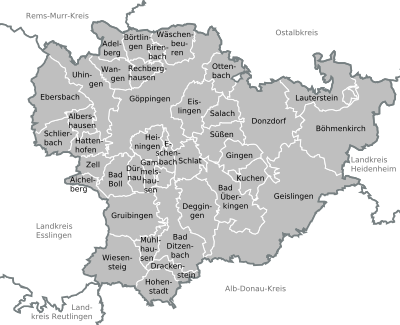  |
Municipalities before the district reform
Before the district reform in 1973 or before the community reform , the Göppingen district had a total of 65 communities since 1938 , including 5 towns . In 1939 Holzheim, 1956 Bartenbach and 1957 Bezgenriet were incorporated into the city of Göppingen and in 1966 Weiler ob Helfenstein was incorporated into the city of Geislingen an der Steige . So there were only 61 parishes left.
On March 7, 1968, the state parliament of Baden-Württemberg set the course for a community reform . With the law to strengthen the administrative power of smaller municipalities , it was possible for smaller municipalities to voluntarily unite to form larger municipalities. The beginning in the district of Göppingen was made on July 1, 1971 by the municipalities of Hausen an der Fils and Oberwälden, which were incorporated into the municipality of Bad Überkingen and the municipality of Wangen , respectively. In the period that followed, the number of communities steadily decreased. All remaining communities in the district of Göppingen were transferred to the new district of Göppingen on January 1, 1973 , but the number of communities continued to decrease in the period that followed.
The largest municipality in the district of Göppingen before the district reform was the district town of Göppingen , which has been a major district town since April 1, 1956 . The smallest community was Oberwälden. The district of Göppingen covered an area of 610 km² before the district reform and had a total of 225,987 inhabitants at the 1970 census . After the district reform in 1973, other communities were elevated to cities, namely Ebersbach an der Fils 1975, Donzdorf 1976, Süßen 1996 and Uhingen 1997.
The table shows the population development of the old district of Göppingen up to 1970. All population figures are census results.
|
|
In the table, the municipalities of the district of Göppingen are before the municipality or district reform without the municipalities of Holzheim, Bartenbach, Jebenhausen and Bezgenriet, which were incorporated into Göppingen before 1966. All communities still belong to the Göppingen district today.

License Plate
On July 1, 1956, the district was assigned the distinctive symbol GP when the vehicle license plates were introduced that are still valid today . It is still issued today.
literature
- The state of Baden-Wuerttemberg - official description according to districts and municipalities (in eight volumes); Edited by the Baden-Württemberg State Archives Department; Volume III: Region Stuttgart - Regionalverband Mittlerer Neckar, Stuttgart 1978, ISBN 3-17-004758-2 .
- Reinhard Wolf , Ulrike Kreh (Hrsg.): The nature reserves in the Stuttgart administrative region . Thorbecke, Ostfildern 2007, ISBN 978-3-7995-5176-2 .
- Göppingen and the district of Göppingen . Then & Now Chronik-Verlag, Pforzheim, 2009. ISBN 978-3-929462-81-4
Web links
- Official website of the district
- Literature from and about the district of Göppingen in the catalog of the German National Library
Individual evidence
- ↑ a b Statistisches Landesamt Baden-Württemberg - Population by nationality and gender on December 31, 2018 (CSV file) ( help on this ).
- ↑ Survey of land according to type of actual use in 2015
- ↑ LUBW protected area statistics ( Memento from January 20, 2015 in the Internet Archive )
- ↑ a b Federal Statistical Office (ed.): Historical municipality register for the Federal Republic of Germany. Name, border and key number changes in municipalities, counties and administrative districts from May 27, 1970 to December 31, 1982 . W. Kohlhammer, Stuttgart / Mainz 1983, ISBN 3-17-003263-1 , p. 448 f. and 461 f .
- ↑ Population by age (5 age groups) and religion Göppingen , 2011 census
- ↑ Church Statistics 2011 , accessed on July 21, 2020
- ↑ Church statistics of the dioceses in Germany 2019 annual survey Diocese Rottenburg-Stuttgart , accessed on July 21, 2020
- ↑ District elections 2019 , on statistik-bw.de
- ↑ Allocation of seats in the district election 2014 , on landkreis-goeppingen.de
- ↑ Distribution of seats in the district election 2009 , on landkreis-goeppingen.de
- ↑ Final result of the district council election according to parties on 07.06.2009 LRA Göppingen with comparison of the results of the district council election 2004, on landkreis-goeppingen.de
- ↑ District election, distribution of votes in the district of Göppingen ( memento from September 6, 2014 in the web archive archive.today ) 1989-2009, on statistik.baden-wuerttemberg.de
- ↑ District election seat allocation for the district of Göppingen ( memento from September 6, 2014 in the web archive archive.today ) 1989-2009, on statistik.baden-wuerttemberg.de
- ^ District council elects Edgar Wolff as the new district administrator of the district of Göppingen - decision in the third ballot , press release of April 3, 2009.
- ↑ Elections bring change ( Memento from January 13, 2016 in the Internet Archive )
- ↑ Future Atlas 2016. Archived from the original on October 2, 2017 ; accessed on March 23, 2018 . Info: The archive link was inserted automatically and has not yet been checked. Please check the original and archive link according to the instructions and then remove this notice.
- ↑ Future Atlas 2019 | Handelsblatt. Retrieved December 10, 2019 .
- ^ Article Kreis says yes to the feasibility study in the Göppinger Kreisnachrichten from January 10, 2007
- ↑ A new chance for the S-Bahn? ( Page no longer available , search in web archives ) Info: The link was automatically marked as defective. Please check the link according to the instructions and then remove this notice. , Esslinger Zeitung from October 20, 2007
- ↑ fairliner.de ( Memento from October 14, 2007 in the Internet Archive )
- ↑ Stuttgart Airport (STR) Public Transportation , on ifly.com, accessed on July 21, 2020
- ↑ Hardly any passengers: exhibition bus is discontinued , Göppinger Kreisnachrichten from October 9, 2008.
Alb-Danube District | Baden-Baden | Biberach | Lake Constance district | Boeblingen | Breisgau-Upper Black Forest | Calw | Emmendingen | Enzkreis | Esslingen | Freiburg im Breisgau | Freudenstadt | Göppingen | Heidelberg | Heidenheim | Heilbronn (Land) | Heilbronn (city) | Hohenlohekreis | Karlsruhe (State) | Karlsruhe (city) | Constance | Loerrach | Ludwigsburg | Main-Tauber district | Mannheim | Neckar-Odenwald district | Ortenaukreis | Ostalbkreis | Pforzheim | Rastatt | Ravensburg | Rems-Murr-Kreis | Reutlingen | Rhein-Neckar District | Rottweil | Schwäbisch Hall | Schwarzwald-Baar district | Sigmaringen | Stuttgart | Tübingen | Tuttlingen | Ulm | Waldshut | Zollernalb district
.svg)
Basking | Backnang | Baden-Baden | Balingen | Biberach | Boeblingen | Bruchsal | Book | Bühl | Calw | Crailsheim | Donaueschingen | Ehingen | Emmendingen | Esslingen | Freiburg (city) | Freiburg (State) | Freudenstadt | Friedrichshafen | Göppingen | Hechingen | Heidelberg (city) | Heidelberg (Country) | Heidenheim | Heilbronn (city) | Heilbronn (Land) | Black Forest | Horb | Karlsruhe (city) | Karlsruhe (State) | Throat | Constance (city) | Constance (Country) | Künzelsau | Lahr | Leonberg | Loerrach | Ludwigsburg | Mannheim (city) | Mannheim (State) | Mergentheim | Mosbach | Muellheim | Münsingen | Neustadt | Nürtingen | Offenburg | Öhringen | Pforzheim (city) | Pforzheim (Country) | Rastatt | Ravensburg | Reutlingen | Rottweil | Säckingen | Saulgau | Schwäbisch Gmünd | Schwäbisch Hall | Sigmaringen | Sinsheim | Stockach | Stuttgart | Tauberbischofsheim | Tettnang | Tübingen | Tuttlingen | Überlingen | Ulm (city) | Ulm (State) | Vaihingen | Villingen | Villingen-Schwenningen | Waiblingen | Waldshut | Cheeks | Wolfach